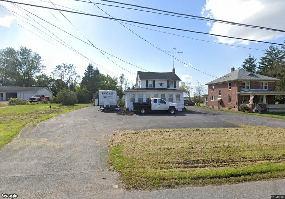
3531 Baltimore Pike Littlestown, PA 17340
Estimated Value: $153,000 - $382,000
3
Beds
3
Baths
1,134
Sq Ft
$230/Sq Ft
Est. Value
About This Home
This home is located at 3531 Baltimore Pike, Littlestown, PA 17340 and is currently estimated at $260,633, approximately $229 per square foot. 3531 Baltimore Pike is a home located in Adams County with nearby schools including Rolling Acres El School, Maple Avenue Middle School, and Littlestown Senior High School.
Ownership History
Date
Name
Owned For
Owner Type
Purchase Details
Closed on
Jan 28, 2020
Sold by
Shuler Pamela J
Bought by
Olinger Daniel D and Olinger Heather N
Current Estimated Value
Purchase Details
Closed on
Oct 15, 2009
Sold by
Straley Steven A and Straley Carol J
Bought by
Shuler Pamela J
Create a Home Valuation Report for This Property
The Home Valuation Report is an in-depth analysis detailing your home's value as well as a comparison with similar homes in the area
Home Values in the Area
Average Home Value in this Area
Purchase History
| Date | Buyer | Sale Price | Title Company |
|---|---|---|---|
| Olinger Daniel D | $50,000 | None Available | |
| Shuler Pamela J | $66,000 | -- |
Source: Public Records
Tax History Compared to Growth
Tax History
| Year | Tax Paid | Tax Assessment Tax Assessment Total Assessment is a certain percentage of the fair market value that is determined by local assessors to be the total taxable value of land and additions on the property. | Land | Improvement |
|---|---|---|---|---|
| 2025 | $2,577 | $156,100 | $47,900 | $108,200 |
| 2024 | $2,785 | $156,100 | $47,900 | $108,200 |
| 2023 | $2,729 | $156,100 | $47,900 | $108,200 |
| 2022 | $2,467 | $156,100 | $47,900 | $108,200 |
| 2021 | $2,635 | $156,100 | $47,900 | $108,200 |
| 2020 | $2,402 | $156,100 | $47,900 | $108,200 |
| 2019 | $2,385 | $156,400 | $48,200 | $108,200 |
| 2018 | $2,489 | $156,400 | $48,200 | $108,200 |
| 2017 | $2,412 | $156,400 | $48,200 | $108,200 |
| 2016 | -- | $156,400 | $48,200 | $108,200 |
| 2015 | -- | $156,400 | $48,200 | $108,200 |
| 2014 | -- | $156,400 | $48,200 | $108,200 |
Source: Public Records
Map
Nearby Homes
- 3801 Baltimore Pike
- 202 Plunkert Rd Unit 2
- 975 Hoffman Home Rd Unit 6
- 464 Locust Ln
- 48 Cannon Ln Unit 105
- 1125 White Church Rd
- 89 Maple St Unit 68
- 795 Burnside Dr Unit 795
- 650 Basehoar Roth Rd
- 824 Hancock Dr Unit 824
- 27 Maple St
- 67 Cedarfield Dr
- 25 Harvest Dr
- 871 Sherman Dr Unit 871
- 0 Hershey Rd Unit PALA2058618
- 230 W Crest View Ln
- 8 Maple St
- 138 Cedarfield Dr Unit 71
- 34 W Hanover St
- 1 Hickory Ave
- 3539 Baltimore Pike
- 3521 Baltimore Pike
- 3555 Baltimore Pike
- 3536 Baltimore Pike
- 3516 Baltimore Pike
- 3557 & 355 Baltimore Pike
- 3550 Baltimore Pike
- 3575 Baltimore Pike
- 3482 Baltimore Pike
- 3585 Baltimore Pike
- 3475 Baltimore Pike
- 12 Hickory Rd
- 10 Hickory Rd
- 9 Hickory Rd
- 120 Hickory Rd
- 3453 Baltimore Pike
- 3435 Baltimore Pike
- 175 Speelman Klinger Rd Unit 5
- 85 Hickory Rd
- 3635 Baltimore Pike