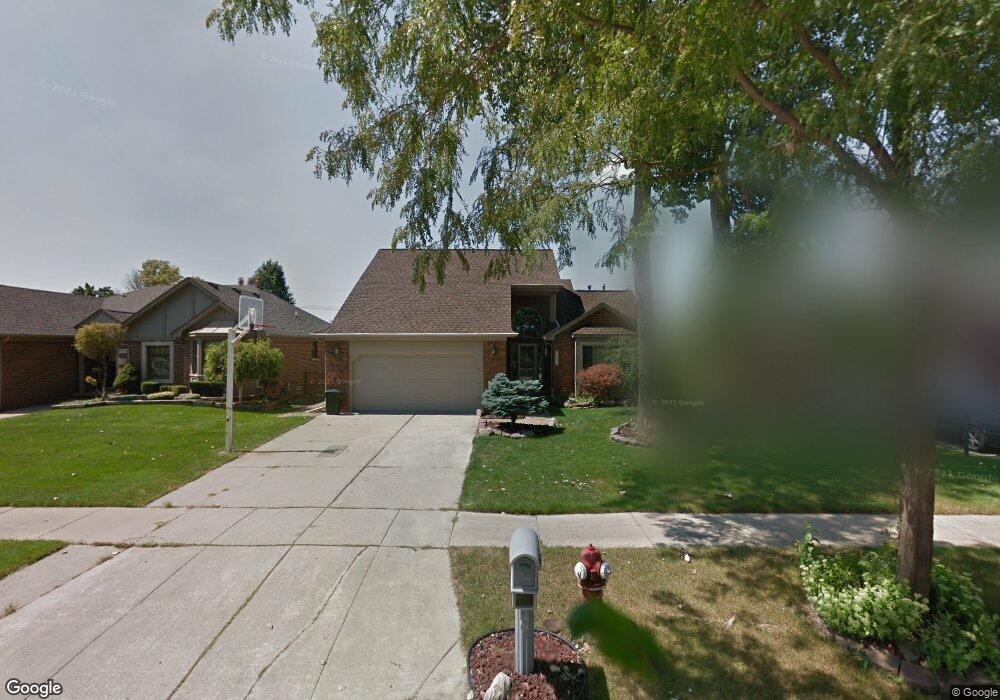
35327 Kensington Ave Sterling Heights, MI 48312
Estimated Value: $337,940 - $426,000
3
Beds
3
Baths
1,855
Sq Ft
$213/Sq Ft
Est. Value
About This Home
This home is located at 35327 Kensington Ave, Sterling Heights, MI 48312 and is currently estimated at $394,735, approximately $212 per square foot. 35327 Kensington Ave is a home located in Macomb County with nearby schools including Willow Woods Elementary School, Carleton Middle School, and Sterling Heights Senior H.S..
Ownership History
Date
Name
Owned For
Owner Type
Purchase Details
Closed on
Apr 28, 2011
Sold by
Stopczynski Lawrence and Stopczynski Mary Ann
Bought by
Dunn Matthew
Current Estimated Value
Home Financials for this Owner
Home Financials are based on the most recent Mortgage that was taken out on this home.
Original Mortgage
$105,000
Outstanding Balance
$72,734
Interest Rate
4.81%
Mortgage Type
New Conventional
Estimated Equity
$322,001
Purchase Details
Closed on
Oct 9, 1996
Sold by
Prainito J and Prainito T
Bought by
Stopczynski L
Create a Home Valuation Report for This Property
The Home Valuation Report is an in-depth analysis detailing your home's value as well as a comparison with similar homes in the area
Home Values in the Area
Average Home Value in this Area
Purchase History
| Date | Buyer | Sale Price | Title Company |
|---|---|---|---|
| Dunn Matthew | $150,000 | Liberty Title | |
| Stopczynski L | $170,000 | -- |
Source: Public Records
Mortgage History
| Date | Status | Borrower | Loan Amount |
|---|---|---|---|
| Open | Dunn Matthew | $105,000 |
Source: Public Records
Tax History Compared to Growth
Tax History
| Year | Tax Paid | Tax Assessment Tax Assessment Total Assessment is a certain percentage of the fair market value that is determined by local assessors to be the total taxable value of land and additions on the property. | Land | Improvement |
|---|---|---|---|---|
| 2025 | $4,464 | $156,300 | $0 | $0 |
| 2024 | $4,306 | $144,100 | $0 | $0 |
| 2023 | $4,088 | $129,100 | $0 | $0 |
| 2022 | $3,964 | $117,100 | $0 | $0 |
| 2021 | $4,097 | $112,600 | $0 | $0 |
| 2020 | $3,895 | $107,800 | $0 | $0 |
| 2019 | $3,574 | $106,700 | $0 | $0 |
| 2018 | $3,874 | $109,400 | $0 | $0 |
| 2017 | $3,735 | $100,600 | $15,000 | $85,600 |
| 2016 | $3,574 | $100,600 | $0 | $0 |
| 2015 | -- | $96,200 | $0 | $0 |
| 2014 | -- | $80,200 | $0 | $0 |
Source: Public Records
Map
Nearby Homes
- 35080 Wellston Ave
- 11437 Forrer Dr
- 7700 15 Mile Rd
- 35517 Turner Dr Unit 237
- 35122 Terrybrook Dr Unit 20
- 11200 Forrer Dr
- 11720 15 Mile Rd Unit A-13, 164
- 8852 Sunrise Dr Unit 4
- 11810 15 Mile Rd Unit 10
- 11740 Seaton Dr Unit 4
- 34821 Valleyview Dr
- 35695 Bonneville Dr
- 11919 Ina Dr
- 12029 Ina Dr Unit 100 Bld 3D
- 12227 Polara Dr
- 11053 Lorman Dr
- 8469 Heywood Cir Unit 58
- 34457 Maple Lane Dr
- 34574 Maple Lane Dr
- 12284 Polara Dr
- 35339 Kensington Ave
- 35315 Kensington Ave
- 35348 Ellsworth Dr
- 35351 Kensington Ave
- 35336 Ellsworth Dr
- 35303 Kensington Ave
- 35360 Ellsworth Dr
- 35324 Ellsworth Dr
- 35372 Ellsworth Dr
- 35363 Kensington Ave
- 35163 Kensington Ave
- 35328 Kensington Ave
- 35312 Kensington Ave
- 35312 Ellsworth Dr
- 35344 Kensington Ave
- 35384 Ellsworth Dr
- 35375 Kensington Ave Unit Bldg-Unit
- 35375 Kensington Ave
- 35151 Kensington Ave
- 35358 Kensington Ave