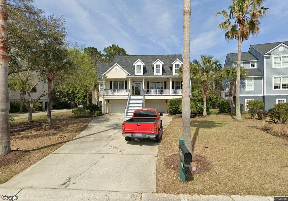
3539 Stockton Dr Mount Pleasant, SC 29466
Charleston National NeighborhoodEstimated Value: $1,116,000 - $1,273,000
5
Beds
4
Baths
3,220
Sq Ft
$374/Sq Ft
Est. Value
About This Home
This home is located at 3539 Stockton Dr, Mount Pleasant, SC 29466 and is currently estimated at $1,204,056, approximately $373 per square foot. 3539 Stockton Dr is a home located in Charleston County with nearby schools including Carolina Park Elementary, Thomas C. Cario Middle School, and Wando High School.
Ownership History
Date
Name
Owned For
Owner Type
Purchase Details
Closed on
Dec 22, 2011
Sold by
Ralston Matthew and Ralston Karen West
Bought by
Todd Caleb E and Todd Anna K
Current Estimated Value
Home Financials for this Owner
Home Financials are based on the most recent Mortgage that was taken out on this home.
Original Mortgage
$324,000
Outstanding Balance
$222,169
Interest Rate
4.06%
Mortgage Type
New Conventional
Estimated Equity
$981,887
Purchase Details
Closed on
Apr 27, 2001
Sold by
Centex Homes
Bought by
Ralston Matthew and Ralston Karen West
Create a Home Valuation Report for This Property
The Home Valuation Report is an in-depth analysis detailing your home's value as well as a comparison with similar homes in the area
Home Values in the Area
Average Home Value in this Area
Purchase History
| Date | Buyer | Sale Price | Title Company |
|---|---|---|---|
| Todd Caleb E | $360,000 | -- | |
| Ralston Matthew | $364,483 | -- |
Source: Public Records
Mortgage History
| Date | Status | Borrower | Loan Amount |
|---|---|---|---|
| Open | Todd Caleb E | $324,000 |
Source: Public Records
Tax History Compared to Growth
Tax History
| Year | Tax Paid | Tax Assessment Tax Assessment Total Assessment is a certain percentage of the fair market value that is determined by local assessors to be the total taxable value of land and additions on the property. | Land | Improvement |
|---|---|---|---|---|
| 2024 | $2,126 | $21,250 | $0 | $0 |
| 2023 | $2,126 | $21,250 | $0 | $0 |
| 2022 | $1,769 | $19,050 | $0 | $0 |
| 2021 | $1,944 | $19,050 | $0 | $0 |
| 2020 | $2,010 | $19,050 | $0 | $0 |
| 2019 | $1,754 | $16,560 | $0 | $0 |
| 2017 | $1,729 | $16,560 | $0 | $0 |
| 2016 | $1,646 | $16,560 | $0 | $0 |
| 2015 | $1,721 | $16,560 | $0 | $0 |
| 2014 | $1,457 | $0 | $0 | $0 |
| 2011 | -- | $0 | $0 | $0 |
Source: Public Records
Map
Nearby Homes
- 3571 Franklin Tower Dr
- 1192 Old Course Ln
- 1615 Macoma Rd
- 1350 Belhaven Dr
- 3638 Zacoma Dr
- 1199 Landau Ln
- 1317 Royal Links Dr
- 3429 Oxfordshire Ln
- 1167 Landau Ln
- 3658 Zacoma Dr
- 3651 Pandora Dr
- 0 Lieben Rd Unit 21005962
- 3635 Pandora Dr
- 0 Pandora Dr
- 1137 Happyland Blvd
- 1401 Lieben Rd
- 1340 Lucinda St
- 1543 Macoma Rd
- 1350 Lucinda St
- 3627 Marginal Rd
- 3543 Stockton Dr
- 3535 Stockton Dr
- 3531 Stockton Dr
- 3547 Stockton Dr
- 3538 Stockton Dr
- 3530 Stockton Dr
- 3527 Stockton Dr
- 3551 Stockton Dr
- 3600 Purple Martin Ct
- 3546 Stockton Dr
- 3597 Purple Martin Ct
- 3523 Stockton Dr
- 3522 Stockton Dr
- 1305 Divot Ct
- 3550 Stockton Dr
- 3604 Purple Martin Ct
- 3601 Purple Martin Ct
- 3519 Stockton Dr
- 3555 Stockton Dr
- 1309 Divot Ct