Estimated Value: $230,000 - $292,849
4
Beds
4
Baths
2,392
Sq Ft
$111/Sq Ft
Est. Value
About This Home
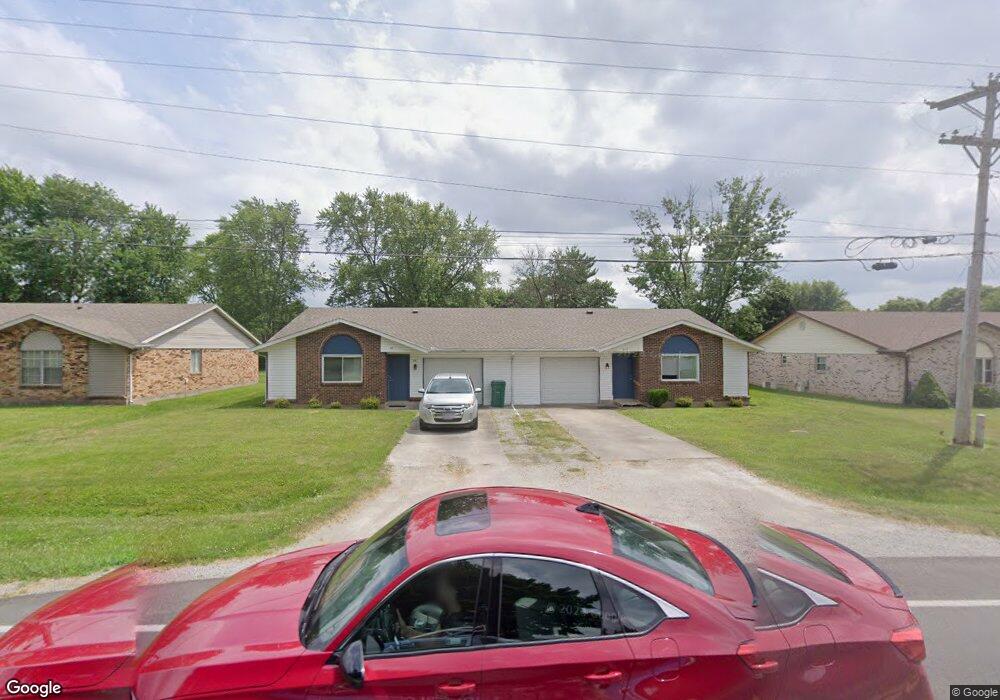
This home is located at 354 Monroe Concord Rd, Troy, OH 45373 and is currently estimated at $266,462, approximately $111 per square foot. 354 Monroe Concord Rd is a home located in Miami County with nearby schools including Concord Elementary School, Van Cleve Elementary School, and Troy Junior High School.
Ownership History
Date
Name
Owned For
Owner Type
Purchase Details
Closed on
Apr 25, 2016
Sold by
New Carlisle Federal Savings Bank
Bought by
Tradan Properties Llc
Current Estimated Value
Purchase Details
Closed on
May 27, 2015
Sold by
Heidenreich Robert L
Bought by
New Carlisle Federal Savings Bank
Purchase Details
Closed on
Dec 1, 1988
Bought by
Heidenreich Robert L
Create a Home Valuation Report for This Property
The Home Valuation Report is an in-depth analysis detailing your home's value as well as a comparison with similar homes in the area
Home Values in the Area
Average Home Value in this Area
Purchase History
| Date | Buyer | Sale Price | Title Company |
|---|---|---|---|
| Tradan Properties Llc | $67,500 | Attorney | |
| New Carlisle Federal Savings Bank | $80,000 | None Available | |
| Heidenreich Robert L | -- | -- |
Source: Public Records
Tax History
| Year | Tax Paid | Tax Assessment Tax Assessment Total Assessment is a certain percentage of the fair market value that is determined by local assessors to be the total taxable value of land and additions on the property. | Land | Improvement |
|---|---|---|---|---|
| 2025 | $3,416 | $88,870 | $12,810 | $76,060 |
| 2024 | $3,416 | $66,710 | $14,420 | $52,290 |
| 2023 | $2,818 | $66,710 | $14,420 | $52,290 |
| 2022 | $2,398 | $66,710 | $14,420 | $52,290 |
| 2021 | $1,816 | $49,430 | $10,680 | $38,750 |
| 2020 | $1,818 | $49,430 | $10,680 | $38,750 |
| 2019 | $1,833 | $49,430 | $10,680 | $38,750 |
| 2018 | $1,771 | $45,510 | $11,310 | $34,200 |
| 2017 | $1,787 | $45,510 | $11,310 | $34,200 |
| 2016 | $1,732 | $45,510 | $11,310 | $34,200 |
| 2015 | $1,763 | $42,950 | $10,680 | $32,270 |
| 2014 | $1,679 | $42,950 | $10,680 | $32,270 |
| 2013 | $1,690 | $42,950 | $10,680 | $32,270 |
Source: Public Records
Map
Nearby Homes
- 591 Countryside Dr S
- 974 Stony Brook Ln
- 2882 Red Oak Cir
- 173 Countryside Dr N
- 2685 Merrimont Dr
- 2550 Broken Woods Dr
- 999 Brookwood Dr
- 1245 Wind Rock Dr
- 1704 Chevington Chase
- 1704 Chevington Chase
- 20 Boone Dr
- 1234 Wind Rock Dr
- 2672 Pleasant View Dr
- 2650 Pleasant View Dr
- 120 Windmere Dr
- 1117 Honeydew Dr
- 807 Claymore Ct
- 1240 Wind Rock Dr
- 1231 Wind Rock Ct
- 0 Lincolnshire Unit 939331
- 338 Monroe Concord Rd
- 366 Monroe Concord Rd
- 3080 Honeysuckle Dr
- 3072 Honeysuckle Dr
- 378 Monroe Concord Rd
- 3100 Honeysuckle Dr
- 3018 Dogwood Dr
- 424 Brookwood Dr
- 3050 Honeysuckle Dr
- 388 Monroe Concord Rd
- 3112 Honeysuckle Dr
- 3085 Honeysuckle Dr
- 3070 Dogwood Dr
- 400 Brookwood Dr
- 3015 Dogwood Dr
- 410 Monroe Concord Rd
- 3033 Dogwood Dr
- 3128 Honeysuckle Dr
- 480 Brookwood Dr
- 3055 Dogwood Dr
Your Personal Tour Guide
Ask me questions while you tour the home.