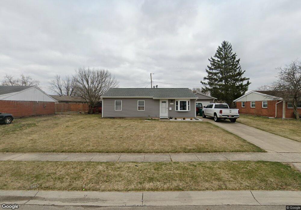
354 Weinland St New Carlisle, OH 45344
Estimated Value: $134,000 - $182,000
3
Beds
1
Bath
925
Sq Ft
$168/Sq Ft
Est. Value
About This Home
This home is located at 354 Weinland St, New Carlisle, OH 45344 and is currently estimated at $155,449, approximately $168 per square foot. 354 Weinland St is a home located in Clark County with nearby schools including Park Layne Elementary School, New Carlisle Elementary School, and Donnelsville Elementary School.
Ownership History
Date
Name
Owned For
Owner Type
Purchase Details
Closed on
Sep 18, 2020
Sold by
Parrish James F and Parrish Wanda L
Bought by
Childers Jacob
Current Estimated Value
Home Financials for this Owner
Home Financials are based on the most recent Mortgage that was taken out on this home.
Original Mortgage
$45,680
Outstanding Balance
$40,276
Interest Rate
2.8%
Mortgage Type
New Conventional
Estimated Equity
$115,173
Purchase Details
Closed on
May 1, 1985
Sold by
Hall Darryl and Hall Judith A
Bought by
Parrish James F and Parrish Wanda L
Create a Home Valuation Report for This Property
The Home Valuation Report is an in-depth analysis detailing your home's value as well as a comparison with similar homes in the area
Home Values in the Area
Average Home Value in this Area
Purchase History
| Date | Buyer | Sale Price | Title Company |
|---|---|---|---|
| Childers Jacob | $57,100 | Home Services Title | |
| Parrish James F | $26,500 | -- |
Source: Public Records
Mortgage History
| Date | Status | Borrower | Loan Amount |
|---|---|---|---|
| Open | Childers Jacob | $45,680 |
Source: Public Records
Tax History Compared to Growth
Tax History
| Year | Tax Paid | Tax Assessment Tax Assessment Total Assessment is a certain percentage of the fair market value that is determined by local assessors to be the total taxable value of land and additions on the property. | Land | Improvement |
|---|---|---|---|---|
| 2024 | $1,474 | $30,080 | $6,950 | $23,130 |
| 2023 | $1,474 | $30,080 | $6,950 | $23,130 |
| 2022 | $1,486 | $30,080 | $6,950 | $23,130 |
| 2021 | $939 | $25,920 | $5,300 | $20,620 |
| 2020 | $941 | $25,920 | $5,300 | $20,620 |
| 2019 | $909 | $25,920 | $5,300 | $20,620 |
| 2018 | $804 | $22,460 | $5,160 | $17,300 |
| 2017 | $799 | $22,845 | $5,159 | $17,686 |
| 2016 | $766 | $22,845 | $5,159 | $17,686 |
| 2015 | $321 | $22,509 | $4,823 | $17,686 |
| 2014 | $639 | $22,509 | $4,823 | $17,686 |
| 2013 | $320 | $22,509 | $4,823 | $17,686 |
Source: Public Records
Map
Nearby Homes
- 419 E Carpenter Dr
- 1037 Frayne Dr
- 819 Hedwick St
- 634 Bowser Dr
- 842 Edgewick Rd
- 16 Laurel Rd
- 1689 Dale Ridge Rd
- 212 Monroe Way
- 209 Monroe Way
- 0 Kennedy Rd
- 12165 Dille Rd
- 9892 S Palmer Rd
- 0 N Dayton-Lakeview Rd Unit 944532
- 0 N Dayton-Lakeview Rd Unit 1041631
- 232 E Main St
- 1292 Medway New Carlisle Rd
- 11315 W National Rd
- 738 S Medway Carlisle Rd
- 11501 Zeller Dr
- 9705 E Haskett Ln
- 354 Weinland Dr
- 348 Weinland Dr
- 364 Weinland Dr
- 1253 Campbell Ave
- 1247 Wendall Ave
- 357 Weinland Dr
- 342 Weinland Dr
- 1245 Campbell Ave
- 365 Weinland Dr
- 1241 Wendall Ave
- 343 Weinland Dr
- 334 Weinland Dr
- 371 Weinland Dr
- 1320 Cooper Ave
- 410 Weinland St
- 410 Weinland Dr
- 1258 Campbell Ave
- 1250 Campbell Ave
- 1235 Wendall Ave
- 335 Weinland Dr