


35400 County Road 59 Hayden, CO 81639
Estimated payment $1,110/month
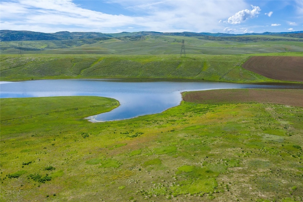
About This Lot
This is truly Big Sky Country! Johnson Ranch, a 35-acre subdivision, is located a short ten minutes south of US Highway 40 and the Town of Hayden, yet feels miles away from the hustle and bustle. Johnson Ranch is served by a shared well and this lot has already tapped in. The topography is gently rolling, covered with native grasses and a smattering of alfalfa. Buy now, build tomorrow and enjoy country living in the wide open spaces of West Routt!
Listing Agent
The Group Real Estate, LLC Brokerage Phone: (970) 870-8800 License #FA100007272 Listed on: 06/06/2025
Property Details
Property Type
- Land
Est. Annual Taxes
- $1,052
Lot Details
- 35.06 Acre Lot
- Zoning described as Agricultural
Schools
- Hayden Elementary And Middle School
- Hayden High School
Utilities
- Propane
- Shared Well
- Septic Tank
- Septic System
Community Details
- No Home Owners Association
- Johnson Ranch Subdivision
Listing and Financial Details
- Assessor Parcel Number R8169235
Map
Home Values in the Area
Average Home Value in this Area
Tax History
| Year | Tax Paid | Tax Assessment Tax Assessment Total Assessment is a certain percentage of the fair market value that is determined by local assessors to be the total taxable value of land and additions on the property. | Land | Improvement |
|---|---|---|---|---|
| 2024 | $3,808 | $52,730 | $52,730 | $0 |
| 2023 | $3,808 | $52,730 | $52,730 | $0 |
| 2022 | $1,052 | $13,630 | $13,630 | $0 |
| 2021 | $74 | $1,030 | $1,030 | $0 |
| 2020 | $90 | $1,250 | $1,250 | $0 |
| 2019 | $91 | $1,250 | $0 | $0 |
| 2018 | $369 | $5,080 | $0 | $0 |
| 2017 | $298 | $5,080 | $0 | $0 |
| 2016 | $253 | $4,440 | $4,440 | $0 |
| 2015 | $250 | $4,440 | $4,440 | $0 |
| 2014 | $1,558 | $27,550 | $27,550 | $0 |
| 2012 | -- | $30,450 | $30,450 | $0 |
Property History
| Date | Event | Price | Change | Sq Ft Price |
|---|---|---|---|---|
| 06/06/2025 06/06/25 | Price Changed | $185,000 | 0.0% | -- |
| 06/06/2025 06/06/25 | For Sale | $185,000 | 0.0% | -- |
| 06/06/2025 06/06/25 | For Sale | $185,000 | +12.1% | -- |
| 08/31/2024 08/31/24 | Off Market | $165,000 | -- | -- |
| 05/06/2024 05/06/24 | For Sale | $165,000 | +371.4% | -- |
| 02/12/2015 02/12/15 | Sold | $35,000 | 0.0% | -- |
| 01/13/2015 01/13/15 | Pending | -- | -- | -- |
| 12/22/2014 12/22/14 | For Sale | $35,000 | -- | -- |
Purchase History
| Date | Type | Sale Price | Title Company |
|---|---|---|---|
| Quit Claim Deed | -- | None Available |
Source: Summit MLS
MLS Number: S1059518
APN: R8169235
Disclaimer: Certain information contained herein is derived from information provided by parties other than Homes.com. All information provided is deemed reliable, but is not guaranteed to be accurate and should be independently verified.
![]() Copyright © 2025 SAR MLS. The information displayed herein was derived from sources believed to be accurate, but has not been verified by SAR MLS. Buyers are cautioned to verify all information to their own satisfaction. This information is exclusively for viewers’ personal, non-commercial use. Any republication or reproduction of the information herein without the express permission of the SAR MLS is strictly prohibited.
Copyright © 2025 SAR MLS. The information displayed herein was derived from sources believed to be accurate, but has not been verified by SAR MLS. Buyers are cautioned to verify all information to their own satisfaction. This information is exclusively for viewers’ personal, non-commercial use. Any republication or reproduction of the information herein without the express permission of the SAR MLS is strictly prohibited.
- 35300 County Road 59
- 6550 Stewart Ln
- 35000 County Road 59
- 35455 County Road 59
- 35755 County Road 59
- 35555 County Road 59
- 33500 County Road 59a
- 38300 Cattails Ct
- 38290 Hillcrest Ct
- 38620 Hidden Springs Dr
- 38750 Hidden Springs Dr
- 376 Lake View Rd
- 347 Mariposa Dr
- 371 Lake View Rd
- 357 Lake View Rd
- 000 Sunflower Dr
- 352 Lake View Rd
