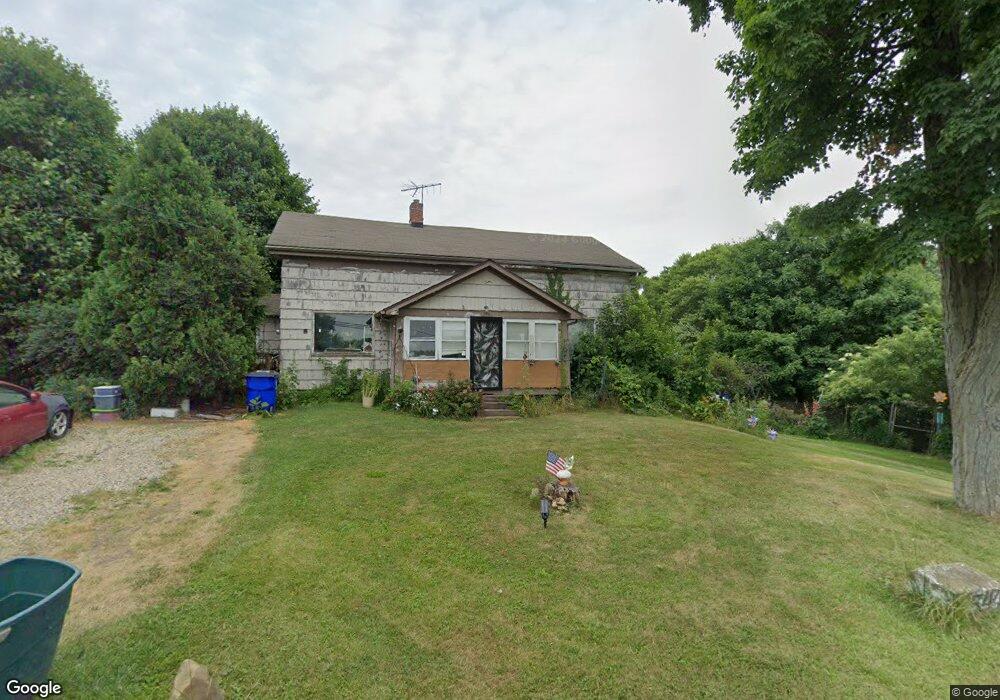
3544 Cook Rd Rootstown, OH 44272
Estimated Value: $133,864 - $352,000
4
Beds
1
Bath
1,426
Sq Ft
$158/Sq Ft
Est. Value
About This Home
This home is located at 3544 Cook Rd, Rootstown, OH 44272 and is currently estimated at $224,966, approximately $157 per square foot. 3544 Cook Rd is a home located in Portage County with nearby schools including Rootstown Middle School - Schnee Building and Rootstown High School.
Ownership History
Date
Name
Owned For
Owner Type
Purchase Details
Closed on
Jan 13, 2003
Sold by
Seni Robert J
Bought by
Seni Kendra S
Current Estimated Value
Purchase Details
Closed on
Jul 2, 1998
Sold by
Orlandi Stephen C
Bought by
Seni Robert J and Seni Kendra S
Home Financials for this Owner
Home Financials are based on the most recent Mortgage that was taken out on this home.
Original Mortgage
$82,000
Outstanding Balance
$17,044
Interest Rate
7.18%
Mortgage Type
New Conventional
Estimated Equity
$207,922
Create a Home Valuation Report for This Property
The Home Valuation Report is an in-depth analysis detailing your home's value as well as a comparison with similar homes in the area
Purchase History
| Date | Buyer | Sale Price | Title Company |
|---|---|---|---|
| Seni Kendra S | -- | Guardian Title | |
| Seni Robert J | $90,000 | -- |
Source: Public Records
Mortgage History
| Date | Status | Borrower | Loan Amount |
|---|---|---|---|
| Open | Seni Robert J | $82,000 |
Source: Public Records
Tax History
| Year | Tax Paid | Tax Assessment Tax Assessment Total Assessment is a certain percentage of the fair market value that is determined by local assessors to be the total taxable value of land and additions on the property. | Land | Improvement |
|---|---|---|---|---|
| 2024 | $1,011 | $23,210 | $10,470 | $12,740 |
| 2023 | $1,042 | $21,490 | $9,240 | $12,250 |
| 2022 | $1,019 | $21,490 | $9,240 | $12,250 |
| 2021 | $1,006 | $21,490 | $9,240 | $12,250 |
| 2020 | $935 | $19,190 | $8,790 | $10,400 |
| 2019 | $938 | $19,190 | $8,790 | $10,400 |
| 2017 | $1,026 | $19,960 | $9,350 | $10,610 |
| 2016 | $992 | $19,960 | $9,350 | $10,610 |
Source: Public Records
Map
Nearby Homes
- 4312 Apple Orchard
- 3689 Cherry Hill
- 3701 State Route 44
- 4225 Hattrick Rd
- 0 Tallmadge Rd Unit 5189301
- 0 Tallmadge Rd Unit 5189314
- 0 Lynn Rd Unit 5110102
- 3021 Hartville Rd
- 3637 Old Forge Rd
- V/L 2 Lynn Rd
- V/L Lynn Rd
- 4415 Farmette Dr
- 4691 Scenic Dr
- 4958 Bassett Rd
- 2547 Industry Rd
- sub lot Lane Ave
- 4087 Industry
- 3080 Saxe Rd
- 4140 Sandy Lake Rd
- 4324 Abbey Ln
Your Personal Tour Guide
Ask me questions while you tour the home.