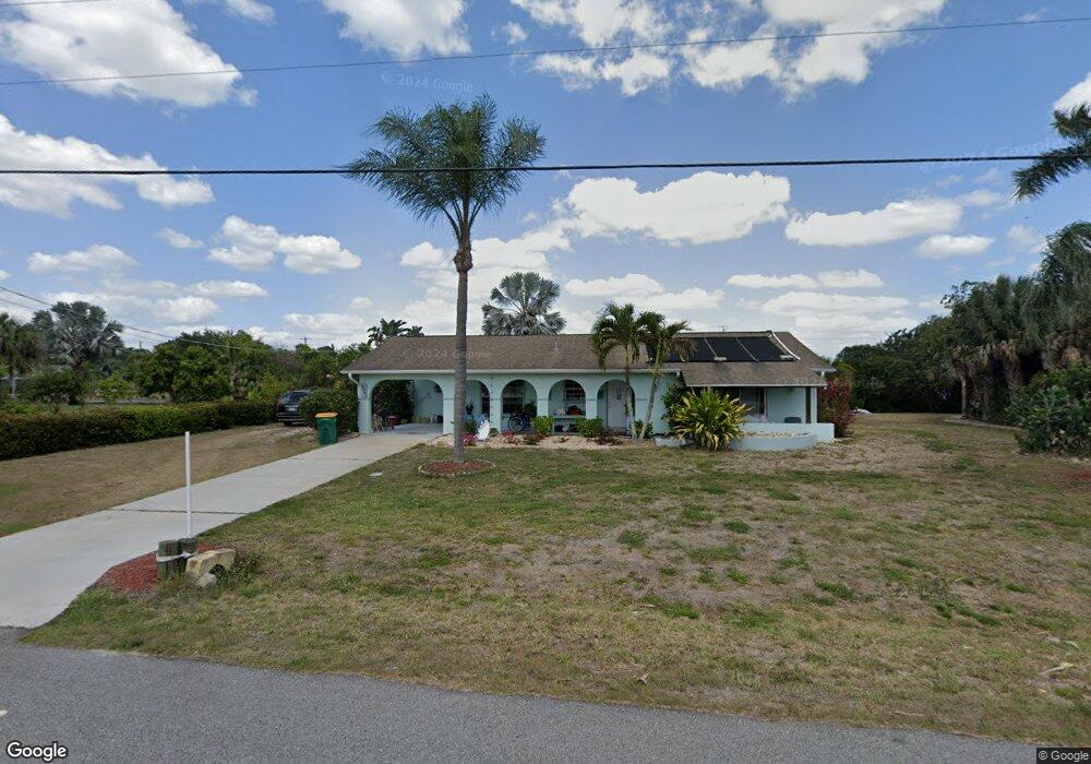
3544 Yukon Dr Port Charlotte, FL 33948
Estimated Value: $257,000 - $418,000
3
Beds
2
Baths
1,220
Sq Ft
$265/Sq Ft
Est. Value
About This Home
This home is located at 3544 Yukon Dr, Port Charlotte, FL 33948 and is currently estimated at $323,104, approximately $264 per square foot. 3544 Yukon Dr is a home located in Charlotte County with nearby schools including Meadow Park Elementary School, Murdock Middle School, and Port Charlotte High School.
Ownership History
Date
Name
Owned For
Owner Type
Purchase Details
Closed on
Feb 18, 2004
Sold by
Weidner Steven A and Weidner Susan A
Bought by
Weidner Steven A and Weidner Susan A
Current Estimated Value
Purchase Details
Closed on
Sep 27, 2002
Sold by
Erb Don and Erb Sally
Bought by
Weidner Steven A and Weidner Susan A
Home Financials for this Owner
Home Financials are based on the most recent Mortgage that was taken out on this home.
Original Mortgage
$140,000
Interest Rate
6.19%
Mortgage Type
Purchase Money Mortgage
Purchase Details
Closed on
Jan 26, 2000
Sold by
Coup Donald L and Coup Joanne M
Bought by
Erb Don and Erb Sally
Create a Home Valuation Report for This Property
The Home Valuation Report is an in-depth analysis detailing your home's value as well as a comparison with similar homes in the area
Home Values in the Area
Average Home Value in this Area
Purchase History
| Date | Buyer | Sale Price | Title Company |
|---|---|---|---|
| Weidner Steven A | -- | -- | |
| Weidner Steven A | $175,000 | -- | |
| Erb Don | $118,000 | -- |
Source: Public Records
Mortgage History
| Date | Status | Borrower | Loan Amount |
|---|---|---|---|
| Previous Owner | Weidner Steven A | $140,000 |
Source: Public Records
Tax History Compared to Growth
Tax History
| Year | Tax Paid | Tax Assessment Tax Assessment Total Assessment is a certain percentage of the fair market value that is determined by local assessors to be the total taxable value of land and additions on the property. | Land | Improvement |
|---|---|---|---|---|
| 2023 | $2,050 | $122,025 | $0 | $0 |
| 2022 | $1,961 | $118,471 | $0 | $0 |
| 2021 | $1,794 | $105,913 | $0 | $0 |
| 2020 | $1,729 | $103,332 | $0 | $0 |
| 2019 | $1,642 | $101,009 | $0 | $0 |
| 2018 | $1,502 | $99,126 | $0 | $0 |
| 2017 | $1,482 | $97,087 | $0 | $0 |
| 2016 | $1,467 | $95,090 | $0 | $0 |
| 2015 | $1,452 | $94,429 | $0 | $0 |
| 2014 | $1,427 | $93,680 | $0 | $0 |
Source: Public Records
Map
Nearby Homes
- 4010 Yucatan Cir
- 4009 Yucatan Cir
- 4026 Yucatan Cir
- 4041 and 4049 Yucatan Cir
- 18571 Edgewater Dr
- 18586 Mccoy Ave
- 3454 Yukon Dr
- 4050 Rock Creek Dr
- 4089 Yucatan Cir
- 4041 Michel Tree St
- 3429 Rock Creek Dr
- 18536 Jay Ave
- 18522 Robinson Ave
- 1157 Beaumont Ave
- 19241 Abhenry Cir
- 4194 Yucatan Cir
- 4107 Rock Creek Dr
- 4026 Mcintire St
- 1133 Ware Ave
- 19484 Midway Blvd
- 3526 Yukon Dr
- 3533 Rock Creek Dr
- 3525 Rock Creek Dr
- 3518 Yukon Dr
- 3517 Rock Creek Dr
- 3543 Rock Creek Dr
- 4289 Yucatan Cir
- 4017 Yucatan Cir
- 4018 Yucatan Cir
- 3510 Yukon Dr
- 3493 Rock Creek Dr
- 4025 Yucatan Cir
- 1125 Lodi Ave
- 4273 Yucatan Cir
- 3502 Yukon Dr
- 3534 Rock Creek Dr
- 4011 Rock Creek Dr
- 3542 Rock Creek Dr
- 4265 Yucatan Cir
- 4033 Yucatan Cir