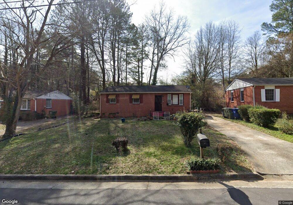
3548 Bolfair Dr NW Atlanta, GA 30331
Carroll Heights NeighborhoodEstimated Value: $167,623 - $202,000
3
Beds
1
Bath
1,000
Sq Ft
$183/Sq Ft
Est. Value
About This Home
This home is located at 3548 Bolfair Dr NW, Atlanta, GA 30331 and is currently estimated at $182,906, approximately $182 per square foot. 3548 Bolfair Dr NW is a home located in Fulton County with nearby schools including Harper-Archer Elementary School, John Lewis Invictus Academy, and Frederick Douglass High School.
Ownership History
Date
Name
Owned For
Owner Type
Purchase Details
Closed on
Sep 29, 1999
Sold by
Benson Bessie L
Bought by
Anderson Amatulmuid A
Current Estimated Value
Home Financials for this Owner
Home Financials are based on the most recent Mortgage that was taken out on this home.
Original Mortgage
$49,591
Outstanding Balance
$14,996
Interest Rate
7.85%
Mortgage Type
FHA
Estimated Equity
$167,910
Purchase Details
Closed on
Sep 24, 1999
Sold by
Anderson Amatulmuid A
Bought by
Anderson Amatulmuid A and Anderson Abubakar A
Home Financials for this Owner
Home Financials are based on the most recent Mortgage that was taken out on this home.
Original Mortgage
$49,591
Outstanding Balance
$14,996
Interest Rate
7.85%
Mortgage Type
FHA
Estimated Equity
$167,910
Purchase Details
Closed on
Aug 28, 1995
Sold by
Fleet Finance Inc
Bought by
Lindquist Co Inc The
Create a Home Valuation Report for This Property
The Home Valuation Report is an in-depth analysis detailing your home's value as well as a comparison with similar homes in the area
Home Values in the Area
Average Home Value in this Area
Purchase History
| Date | Buyer | Sale Price | Title Company |
|---|---|---|---|
| Anderson Amatulmuid A | $50,000 | -- | |
| Anderson Amatulmuid A | -- | -- | |
| Lindquist Co Inc The | $23,000 | -- |
Source: Public Records
Mortgage History
| Date | Status | Borrower | Loan Amount |
|---|---|---|---|
| Open | Anderson Amatulmuid A | $49,591 |
Source: Public Records
Tax History Compared to Growth
Tax History
| Year | Tax Paid | Tax Assessment Tax Assessment Total Assessment is a certain percentage of the fair market value that is determined by local assessors to be the total taxable value of land and additions on the property. | Land | Improvement |
|---|---|---|---|---|
| 2025 | $298 | $45,040 | $12,680 | $32,360 |
| 2023 | $2,140 | $51,680 | $23,440 | $28,240 |
| 2022 | $326 | $38,000 | $7,600 | $30,400 |
| 2021 | $247 | $18,720 | $1,720 | $17,000 |
| 2020 | $247 | $18,720 | $1,720 | $17,000 |
| 2019 | $488 | $18,720 | $1,720 | $17,000 |
| 2018 | $33 | $15,640 | $7,160 | $8,480 |
| 2017 | $19 | $11,000 | $4,720 | $6,280 |
| 2016 | $19 | $11,000 | $4,720 | $6,280 |
| 2015 | $501 | $11,000 | $4,720 | $6,280 |
| 2014 | $13 | $7,920 | $2,800 | $5,120 |
Source: Public Records
Map
Nearby Homes
- 805 Sandy Creek Dr NW
- 3590 Bolfair Dr NW
- 825 Bolton Place NW
- 836 Bolton Rd NW
- 980 Fairburn Rd NW
- 935 Fairburn Rd NW
- 3645 Croft Place NW
- 905 Fairburn Rd NW
- 3674 Saturn Dr NW
- 3650 Croft Place NW
- 731 Bolton Rd NW
- 3429 Adkins Rd NW
- 3436 Adkins Rd NW
- 831 Mercury Dr NW
- 881 Mercury Dr NW
- 3410 Adkins Rd NW
- 830 Mercury Dr NW
- 685 Bolton Rd NW
- 3552 Bolfair Dr NW
- 3554 Bolfair Dr NW
- 3542 Bolfair Dr NW
- 3560 Bolfair Dr NW
- 3536 Bolfair Dr NW
- 3566 Bolfair Dr NW
- 3551 Bolfair Dr NW
- 3530 Bolfair Dr NW
- 3557 NW Bolfair 0
- 3557 Bolfair Dr NW Unit 93
- 3557 Bolfair Dr NW
- 3543 Bolfair Dr NW
- 3533 Bolfair Dr NW
- 3572 Bolfair Dr NW
- 3563 Bolfair Dr NW
- 3563 Bolfair Dr NW Unit 3563
- 3524 Bolfair Dr NW
- 3527 Bolfair Dr NW
- 3578 Bolfair Dr NW
- 3518 Bolfair Dr NW