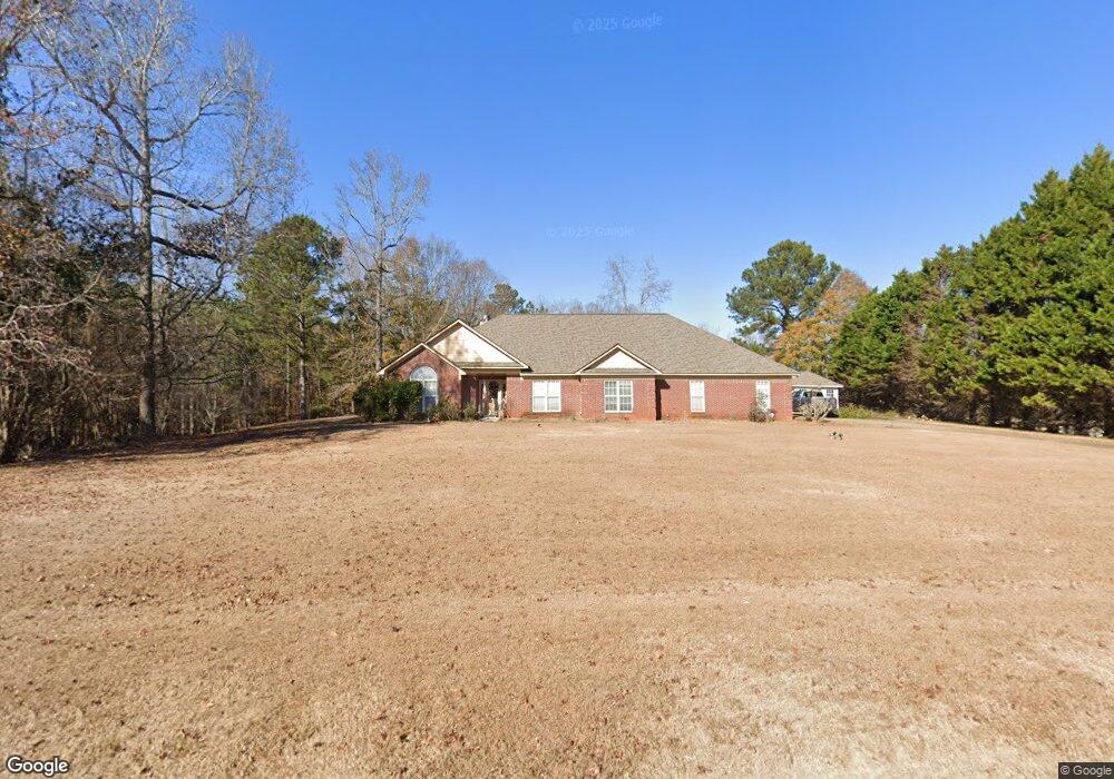
355 Boyd Branch Dr Upatoi, GA 31829
Estimated Value: $448,759 - $522,000
4
Beds
3
Baths
3,207
Sq Ft
$149/Sq Ft
Est. Value
About This Home
This home is located at 355 Boyd Branch Dr, Upatoi, GA 31829 and is currently estimated at $476,586, approximately $148 per square foot. 355 Boyd Branch Dr is a home located in Harris County with nearby schools including Pine Ridge Elementary School, Creekside School, and Harris County Carver Middle School.
Ownership History
Date
Name
Owned For
Owner Type
Purchase Details
Closed on
Aug 27, 2002
Sold by
Parkland Corporation
Bought by
Julien Junius H and Julien Ceolia T
Current Estimated Value
Purchase Details
Closed on
Jun 21, 2002
Sold by
Moon Mike L
Bought by
Parkland Corporation
Create a Home Valuation Report for This Property
The Home Valuation Report is an in-depth analysis detailing your home's value as well as a comparison with similar homes in the area
Purchase History
| Date | Buyer | Sale Price | Title Company |
|---|---|---|---|
| Julien Junius H | $294,700 | -- | |
| Parkland Corporation | $54,900 | -- |
Source: Public Records
Tax History
| Year | Tax Paid | Tax Assessment Tax Assessment Total Assessment is a certain percentage of the fair market value that is determined by local assessors to be the total taxable value of land and additions on the property. | Land | Improvement |
|---|---|---|---|---|
| 2025 | $1,099 | $159,997 | $16,000 | $143,997 |
| 2024 | $1,155 | $154,798 | $16,000 | $138,798 |
| 2023 | $164 | $125,098 | $14,000 | $111,098 |
| 2022 | $771 | $125,098 | $14,000 | $111,098 |
| 2021 | $290 | $106,009 | $14,000 | $92,009 |
| 2020 | $581 | $106,009 | $14,000 | $92,009 |
| 2019 | $665 | $105,026 | $14,000 | $91,026 |
| 2018 | $800 | $105,026 | $14,000 | $91,026 |
| 2017 | $903 | $105,026 | $14,000 | $91,026 |
| 2016 | $2,720 | $104,092 | $14,000 | $90,092 |
| 2015 | $2,725 | $104,092 | $14,000 | $90,092 |
| 2014 | $2,839 | $108,453 | $14,000 | $94,453 |
| 2013 | -- | $114,091 | $24,000 | $90,091 |
Source: Public Records
Map
Nearby Homes
- 0 Boyd Ct
- 3450 Mckee Rd
- 8585 Mckee Rd
- 3056 Bentley Dr
- 7798 Mckee Rd
- 7788 Mckee Rd
- 8705 Mckee Rd
- 7524 Hedgestone Dr
- 13965 Cross Creek Rd
- 14270 Cross Creek Rd
- 561 Abberly Ln
- 7232 Woodhaven Dr
- 13642 Macon Rd
- Tract 1 - 877 Mckee Rd
- Tract 2 - 877 Mckee Rd
- 877 Mckee Rd
- 208 Abberly Ln
- 67 W West Straight St
- 72 W Teddy Bear Ln
- 0 Ga-315
- 409 Boyd Branch Dr
- 319 Boyd Branch Dr
- 354 Boyd Branch Dr
- 473 Boyd Branch Dr
- 20 Boyd Ct
- 18 Hearld Ct
- 264 Boyd Branch Dr
- 72 Boyd Ct
- 437 Boyd Branch Dr
- 31 Hearld Ct
- 252 Boyd Branch Dr
- 124 Boyd Ct
- 56 Hearld Ct
- 485 Boyd Branch Dr
- 33 Boyd Ct
- 174 Boyd Ct
- 67 Branch Ct
- 32 Branch Ct
- 113 Hearld Ct
- 60 Branch Ct
Your Personal Tour Guide
Ask me questions while you tour the home.