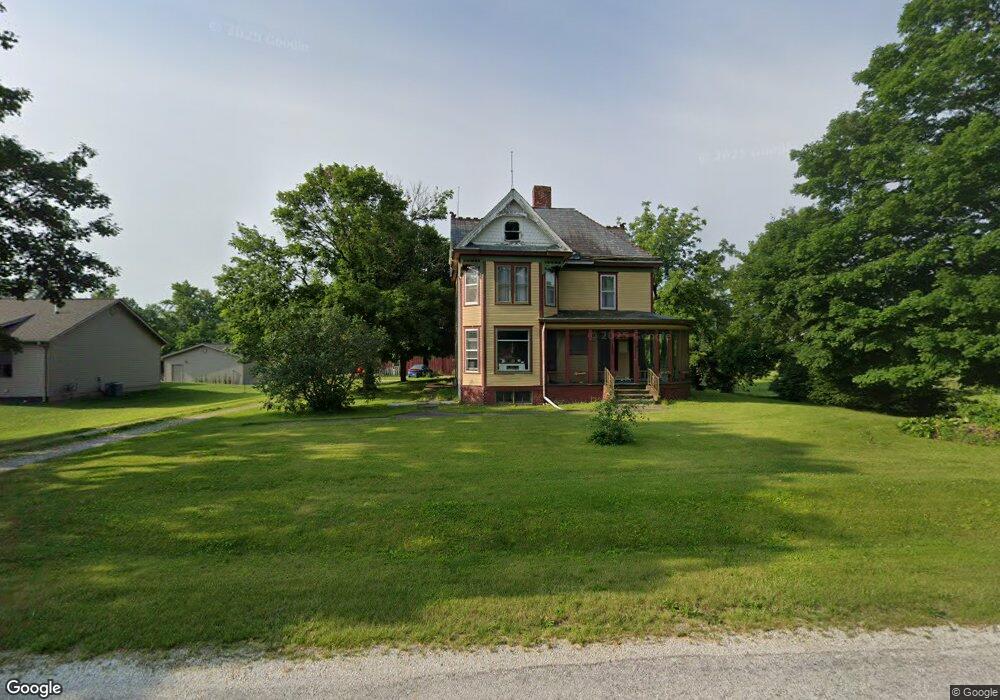
355 E Main St Good Hope, IL 61438
Estimated Value: $88,000 - $142,000
3
Beds
--
Bath
1,385
Sq Ft
$79/Sq Ft
Est. Value
About This Home
This home is located at 355 E Main St, Good Hope, IL 61438 and is currently estimated at $109,381, approximately $78 per square foot. 355 E Main St is a home located in McDonough County with nearby schools including West Prairie High School.
Ownership History
Date
Name
Owned For
Owner Type
Purchase Details
Closed on
Aug 31, 2011
Sold by
Dormire Richard C and Dormire Rhonda D
Bought by
Thompson Kirk A and Thompson Brenda J
Current Estimated Value
Home Financials for this Owner
Home Financials are based on the most recent Mortgage that was taken out on this home.
Original Mortgage
$26,000
Interest Rate
6%
Mortgage Type
Future Advance Clause Open End Mortgage
Purchase Details
Closed on
Mar 21, 2006
Sold by
Norton Timothy R and Norton Viola M
Bought by
Dormire Richard C and Dormire Rhonda D
Home Financials for this Owner
Home Financials are based on the most recent Mortgage that was taken out on this home.
Original Mortgage
$60,000
Interest Rate
6.72%
Mortgage Type
Purchase Money Mortgage
Create a Home Valuation Report for This Property
The Home Valuation Report is an in-depth analysis detailing your home's value as well as a comparison with similar homes in the area
Purchase History
| Date | Buyer | Sale Price | Title Company |
|---|---|---|---|
| Thompson Kirk A | $97,000 | None Available | |
| Cormire Richard C | -- | None Available | |
| Dormire Richard C | $80,000 | None Available |
Source: Public Records
Mortgage History
| Date | Status | Borrower | Loan Amount |
|---|---|---|---|
| Closed | Cormire Richard C | $26,000 | |
| Open | Thompson Kirk A | $73,500 | |
| Previous Owner | Dormire Richard C | $60,000 |
Source: Public Records
Tax History
| Year | Tax Paid | Tax Assessment Tax Assessment Total Assessment is a certain percentage of the fair market value that is determined by local assessors to be the total taxable value of land and additions on the property. | Land | Improvement |
|---|---|---|---|---|
| 2024 | $2,142 | $30,918 | $2,633 | $28,285 |
| 2023 | $2,006 | $29,190 | $2,486 | $26,704 |
| 2022 | $1,885 | $27,710 | $2,360 | $25,350 |
| 2021 | $1,835 | $27,130 | $2,311 | $24,819 |
| 2020 | $1,787 | $28,981 | $2,275 | $26,706 |
| 2019 | $1,838 | $27,262 | $2,322 | $24,940 |
| 2018 | $1,846 | $27,818 | $2,369 | $25,449 |
| 2017 | $1,876 | $27,818 | $2,369 | $25,449 |
| 2016 | $1,834 | $27,273 | $2,323 | $24,950 |
| 2015 | $1,816 | $26,857 | $2,288 | $24,569 |
| 2014 | $1,655 | $26,500 | $2,258 | $24,242 |
| 2013 | $1,528 | $25,000 | $2,130 | $22,870 |
Source: Public Records
Map
Nearby Homes
- 300 E Main St
- 215 N Monmouth St
- 240 S Monmouth St
- 345 S Monmouth St
- 201 N Pine St
- 15465 U S 67
- 17830 E 1600th St
- 105 E Fillmore St
- 19635 E 800th St
- 15315 N 2200th Rd
- 2001 Wigwam Hollow Rd
- 1343 Woodland Trail
- 13 Woodland Ln
- 4 Woodland Ln
- 292 Jana Rd
- 209 W Kurlene Dr
- 1001 Wigwam Hollow Rd
- 1103 Hawthorn Ridge
- 103 Penny Ln
- 1004 N Pearl St
- 405 E Main St
- 415 E Main St
- 400 E Main St
- 140 N Monmouth St
- 420 E Main St
- 445 E Main St
- 0 E Main St
- 440 E Main St
- 235 E Main St
- 240 E Main St
- Lots 1-5 U S Highway 67
- 301 E Main St
- 335 E Railroad St
- 209 S Washington St
- 470 E Main St
- 220 E Main St
- 305 E Railroad St
- 305 S Washington St
- 215 S Washington St
- 200 S Monmouth St
Your Personal Tour Guide
Ask me questions while you tour the home.