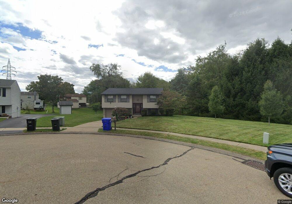
355 Meteor Cir W Freedom, PA 15042
Estimated Value: $258,000 - $272,000
3
Beds
2
Baths
1,860
Sq Ft
$143/Sq Ft
Est. Value
About This Home
This home is located at 355 Meteor Cir W, Freedom, PA 15042 and is currently estimated at $265,958, approximately $142 per square foot. 355 Meteor Cir W is a home located in Beaver County with nearby schools including Ambridge Area Middle School, Ambridge Area High School, and Baden Academy Charter School.
Ownership History
Date
Name
Owned For
Owner Type
Purchase Details
Closed on
Apr 19, 2001
Sold by
Martin Timothy F
Bought by
Saturley Herbert F
Current Estimated Value
Home Financials for this Owner
Home Financials are based on the most recent Mortgage that was taken out on this home.
Original Mortgage
$102,700
Outstanding Balance
$37,521
Interest Rate
6.9%
Estimated Equity
$228,437
Purchase Details
Closed on
Mar 20, 2000
Sold by
Misbrener David R
Bought by
Martin Timothy F
Home Financials for this Owner
Home Financials are based on the most recent Mortgage that was taken out on this home.
Original Mortgage
$75,600
Interest Rate
8.31%
Create a Home Valuation Report for This Property
The Home Valuation Report is an in-depth analysis detailing your home's value as well as a comparison with similar homes in the area
Home Values in the Area
Average Home Value in this Area
Purchase History
| Date | Buyer | Sale Price | Title Company |
|---|---|---|---|
| Saturley Herbert F | $100,000 | -- | |
| Martin Timothy F | $94,500 | -- |
Source: Public Records
Mortgage History
| Date | Status | Borrower | Loan Amount |
|---|---|---|---|
| Open | Saturley Herbert F | $102,700 | |
| Previous Owner | Martin Timothy F | $75,600 |
Source: Public Records
Tax History Compared to Growth
Tax History
| Year | Tax Paid | Tax Assessment Tax Assessment Total Assessment is a certain percentage of the fair market value that is determined by local assessors to be the total taxable value of land and additions on the property. | Land | Improvement |
|---|---|---|---|---|
| 2025 | $2,134 | $100,600 | $22,900 | $77,700 |
| 2024 | $3,597 | $100,600 | $22,900 | $77,700 |
| 2023 | $3,312 | $26,400 | $5,700 | $20,700 |
| 2022 | $3,246 | $26,400 | $5,700 | $20,700 |
| 2021 | $3,246 | $26,400 | $5,700 | $20,700 |
| 2020 | $3,193 | $26,400 | $5,700 | $20,700 |
| 2019 | $3,193 | $26,400 | $5,700 | $20,700 |
| 2018 | $3,136 | $26,400 | $5,700 | $20,700 |
| 2017 | $3,136 | $26,400 | $5,700 | $20,700 |
| 2016 | $2,945 | $26,400 | $5,700 | $20,700 |
| 2015 | $586 | $26,400 | $5,700 | $20,700 |
| 2014 | $586 | $26,400 | $5,700 | $20,700 |
Source: Public Records
Map
Nearby Homes
- 300 Moonridge Dr
- 250 Constellation Dr
- 325 Sunridge Dr
- 190 Orchard Ln
- 615 Nova Dr
- 221 Patriot Ln
- 235 Patriot Ln
- 331 Rolling Hills Rd
- 237 Patriot Ln
- 261 Patriot Ln
- 268 Patriot Ln Unit 148
- 613 Old Glory Ln
- 334 Patriot Ln
- 25 Holly Hill Dr
- 2400 Conway Wallrose Rd
- 155 Sproat Ave
- 140 Kruest Dr
- 198 Pinehurst Dr
- 135 Pinehurst Dr
- 500 Conway Wallrose Rd