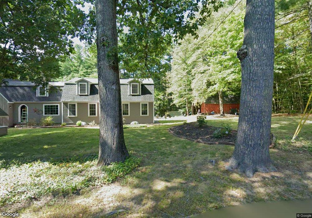
355 Pond St Dunstable, MA 01827
Estimated Value: $848,780 - $1,027,000
--
Bed
3
Baths
2,624
Sq Ft
$362/Sq Ft
Est. Value
About This Home
This home is located at 355 Pond St, Dunstable, MA 01827 and is currently estimated at $950,195, approximately $362 per square foot. 355 Pond St is a home located in Middlesex County with nearby schools including Groton Dunstable Regional High School and 2nd Nature Academy.
Ownership History
Date
Name
Owned For
Owner Type
Purchase Details
Closed on
May 24, 2000
Sold by
Sabo Patrick J and Scott-Sabo Sally
Bought by
Fotino Richard P and Fotino Renee M
Current Estimated Value
Home Financials for this Owner
Home Financials are based on the most recent Mortgage that was taken out on this home.
Original Mortgage
$303,900
Interest Rate
8.1%
Mortgage Type
Purchase Money Mortgage
Purchase Details
Closed on
Dec 21, 1998
Sold by
E & M Rt
Bought by
Sabo Patrick J and Sabo Sally Scott
Purchase Details
Closed on
Aug 15, 1996
Sold by
Kiersey Lt and Kiersey Donald
Bought by
E&M Rt and Sgrosso Elio
Create a Home Valuation Report for This Property
The Home Valuation Report is an in-depth analysis detailing your home's value as well as a comparison with similar homes in the area
Home Values in the Area
Average Home Value in this Area
Purchase History
| Date | Buyer | Sale Price | Title Company |
|---|---|---|---|
| Fotino Richard P | $379,900 | -- | |
| Sabo Patrick J | $355,900 | -- | |
| E&M Rt | $78,000 | -- |
Source: Public Records
Mortgage History
| Date | Status | Borrower | Loan Amount |
|---|---|---|---|
| Open | E&M Rt | $367,000 | |
| Closed | E&M Rt | $50,000 | |
| Closed | E&M Rt | $303,900 |
Source: Public Records
Tax History Compared to Growth
Tax History
| Year | Tax Paid | Tax Assessment Tax Assessment Total Assessment is a certain percentage of the fair market value that is determined by local assessors to be the total taxable value of land and additions on the property. | Land | Improvement |
|---|---|---|---|---|
| 2025 | $10,350 | $752,700 | $233,000 | $519,700 |
| 2024 | $9,839 | $704,800 | $212,000 | $492,800 |
| 2023 | $9,720 | $649,300 | $212,000 | $437,300 |
| 2022 | $8,973 | $588,400 | $212,000 | $376,400 |
| 2021 | $8,561 | $536,800 | $193,400 | $343,400 |
| 2020 | $10,307 | $522,400 | $193,400 | $329,000 |
| 2019 | $8,571 | $502,400 | $193,400 | $309,000 |
| 2018 | $8,360 | $476,600 | $191,100 | $285,500 |
| 2017 | $7,987 | $469,300 | $191,100 | $278,200 |
| 2016 | $7,639 | $461,600 | $182,900 | $278,700 |
| 2015 | $7,447 | $445,100 | $155,200 | $289,900 |
| 2014 | $7,019 | $445,100 | $155,200 | $289,900 |
Source: Public Records
Map
Nearby Homes
- 153 Off Pond St
- 446 Westford St
- 319 Pleasant St
- 660 Old Dunstable Rd
- 2 Wildflower Ln
- 0 Lowell St
- 8 Jamie Rd
- 18 Ingalls Rd
- 0 Old Dunstable Rd
- 6 Ingalls Rd
- 45 Red Gate Rd
- 11 Old Hickory Rd
- 19 Sandstone Rd
- 454 Dunstable Rd
- 15 Stone Ridge Rd
- 160 Westford Rd
- 20 Highland Rd
- 7 Axletree Rd
- 22 Highland Rd
- 1 Summer Village Rd