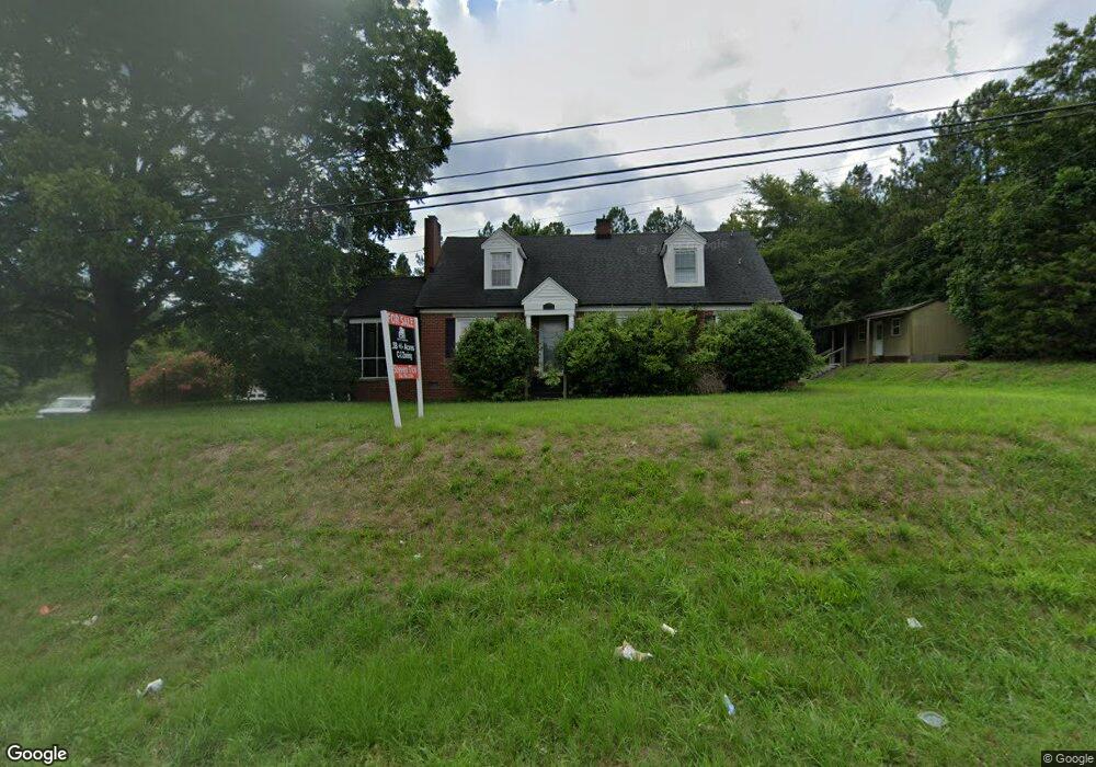
3550 Us Highway 601 S Concord, NC 28025
Estimated Value: $521,000 - $707,000
4
Beds
2
Baths
2,487
Sq Ft
$237/Sq Ft
Est. Value
About This Home
This home is located at 3550 Us Highway 601 S, Concord, NC 28025 and is currently estimated at $589,277, approximately $236 per square foot. 3550 Us Highway 601 S is a home located in Cabarrus County with nearby schools including A.T. Allen Elementary School, C.C. Griffin Middle School, and Central Cabarrus High School.
Ownership History
Date
Name
Owned For
Owner Type
Purchase Details
Closed on
Jun 8, 2023
Sold by
Parker Timothy David
Bought by
Parker Timothy David and Marie Parker Garrett Tara
Current Estimated Value
Purchase Details
Closed on
Feb 3, 2020
Sold by
Parker Timothy David and Parker Garrett Tara Marie
Bought by
Parker Timothy David and Parker Garrett Tara Marie
Create a Home Valuation Report for This Property
The Home Valuation Report is an in-depth analysis detailing your home's value as well as a comparison with similar homes in the area
Home Values in the Area
Average Home Value in this Area
Purchase History
| Date | Buyer | Sale Price | Title Company |
|---|---|---|---|
| Parker Timothy David | -- | None Listed On Document | |
| Parker Timothy David | -- | None Available |
Source: Public Records
Tax History Compared to Growth
Tax History
| Year | Tax Paid | Tax Assessment Tax Assessment Total Assessment is a certain percentage of the fair market value that is determined by local assessors to be the total taxable value of land and additions on the property. | Land | Improvement |
|---|---|---|---|---|
| 2025 | $5,633 | $565,570 | $373,220 | $192,350 |
| 2024 | $5,633 | $565,570 | $373,220 | $192,350 |
| 2023 | $5,174 | $424,080 | $319,910 | $104,170 |
| 2022 | $5,174 | $424,080 | $319,910 | $104,170 |
| 2021 | $5,174 | $424,080 | $319,910 | $104,170 |
| 2020 | $5,174 | $424,080 | $319,910 | $104,170 |
| 2019 | $2,941 | $241,050 | $177,730 | $63,320 |
| 2018 | $2,893 | $241,050 | $177,730 | $63,320 |
| 2017 | $2,844 | $241,050 | $177,730 | $63,320 |
| 2016 | $1,687 | $250,580 | $177,730 | $72,850 |
| 2015 | $1,867 | $250,580 | $177,730 | $72,850 |
| 2014 | $1,867 | $250,580 | $177,730 | $72,850 |
Source: Public Records
Map
Nearby Homes
- 6175 U S 601
- 3560 Us Highway 601 S
- 2752 State Highway 49
- 847 Kathryn Dr SE
- 148 Woodland Dr SW
- 79 Cumberland Ct SW
- 760 Bartram Ave Unit 114
- 668 Shellbark Dr
- 2628 State Highway 49
- 29 Plott Dr SW
- 142 Cottontail Ln SE
- 2905 Atando Rd
- 1051 Manston Place SW
- 4175 Broadstairs Dr
- 4183 Broadstairs Dr
- 3931 Kellybrook Dr
- 425 Krimminger Ave SE
- 4425 Norfleet St
- 4203 Long Arrow Dr
- 4285 Long Arrow Dr
- 1437 Zion Church Rd E
- 1401 Zion Church Rd E
- 1501 Zion Church Rd E Unit 423
- 1501 Zion Church Rd E Unit 421
- 3650 Us Highway 601 S
- 1461 Zion Church Rd E
- 3725 Us Highway 601 S
- 3725 Us Highway 601 S
- 3725 Us Highway 601 S
- 3725 Us Highway 601 S
- 1475 Zion Church Rd E
- 4361 U S 601
- 1457 Zion Church Rd E
- 1393 Zion Church Rd E
- 00 S Us Hwy 601 Hwy
- 3755 Us Highway 601 S
- 1375 Zion Church Rd E
- 3700 Us Highway 601 S
- 1450 Zion Church Rd E
- 1440 Zion Church Rd E