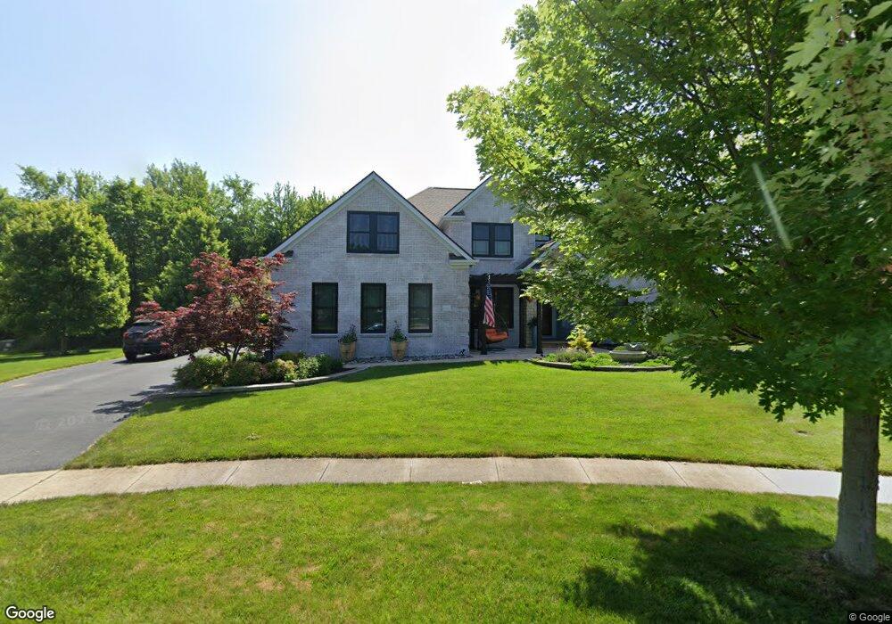
3565 Highground Ct Powell, OH 43065
Estimated Value: $659,000 - $900,000
4
Beds
4
Baths
3,542
Sq Ft
$222/Sq Ft
Est. Value
About This Home
This home is located at 3565 Highground Ct, Powell, OH 43065 and is currently estimated at $787,964, approximately $222 per square foot. 3565 Highground Ct is a home located in Delaware County with nearby schools including Scioto Ridge Elementary School, Olentangy Liberty Middle School, and Olentangy Liberty High School.
Ownership History
Date
Name
Owned For
Owner Type
Purchase Details
Closed on
Sep 27, 2004
Sold by
Centex Homes
Bought by
Decker Patrick J and Decker Debra A
Current Estimated Value
Home Financials for this Owner
Home Financials are based on the most recent Mortgage that was taken out on this home.
Original Mortgage
$350,189
Outstanding Balance
$161,470
Interest Rate
4.75%
Mortgage Type
Purchase Money Mortgage
Estimated Equity
$626,494
Create a Home Valuation Report for This Property
The Home Valuation Report is an in-depth analysis detailing your home's value as well as a comparison with similar homes in the area
Home Values in the Area
Average Home Value in this Area
Purchase History
| Date | Buyer | Sale Price | Title Company |
|---|---|---|---|
| Decker Patrick J | $437,800 | Commerce Title |
Source: Public Records
Mortgage History
| Date | Status | Borrower | Loan Amount |
|---|---|---|---|
| Open | Decker Patrick J | $350,189 |
Source: Public Records
Tax History
| Year | Tax Paid | Tax Assessment Tax Assessment Total Assessment is a certain percentage of the fair market value that is determined by local assessors to be the total taxable value of land and additions on the property. | Land | Improvement |
|---|---|---|---|---|
| 2024 | $17,323 | $276,500 | $50,330 | $226,170 |
| 2023 | $17,380 | $276,500 | $50,330 | $226,170 |
| 2022 | $16,269 | $212,380 | $34,370 | $178,010 |
| 2021 | $14,422 | $185,500 | $34,370 | $151,130 |
| 2020 | $14,467 | $185,500 | $34,370 | $151,130 |
| 2019 | $13,171 | $174,300 | $34,370 | $139,930 |
| 2018 | $12,255 | $160,580 | $34,370 | $126,210 |
| 2017 | $12,292 | $155,020 | $29,120 | $125,900 |
| 2016 | $12,576 | $155,020 | $29,120 | $125,900 |
| 2015 | $11,587 | $155,020 | $29,120 | $125,900 |
| 2014 | $10,661 | $141,020 | $29,090 | $111,930 |
| 2013 | $10,627 | $137,770 | $29,090 | $108,680 |
Source: Public Records
Map
Nearby Homes
- 8574 Trail Lake Dr
- 4816 Rutherford Rd
- 3154 Mapex Ct
- 0 Liberty Rd Unit Tract 3
- 0 Liberty Rd Unit Tract 4
- 0 Liberty Rd Unit Tract 10
- 0 Liberty Rd Unit Tract 2
- 0 Liberty Rd Unit Tract 1
- 0 Liberty Rd Unit Tract 11
- 8778 Linksway Dr
- 1063 Mendolin Ct
- 3443 Village Club Dr
- 8033 Hillingdon Dr Unit 8033
- 3623 Stoneway Point Unit 33623
- 3697 Stoneway Point Unit 83697
- 8989 Samari Place
- 9023 Samari Place
- 3638 Foresta Grand Dr
- 0 Liberty Rd N Unit Lot 4
- 0 Liberty Rd N Unit Lot 6
- 3577 Highground Ct
- 3564 Highground Ct
- 3597 Highground Ct Unit 4023
- 8499 Trail Lake Dr
- 8499 Trail Lake Dr Unit 3993
- 8485 Trail Lake Dr
- 8507 Trail Lake Dr
- 3574 Highground Ct
- 8467 Trail Lake Dr
- 3619 Highground Ct
- 8517 Trail Lake Dr
- 3590 Highground Ct
- 3616 Highground Ct
- 3445 Rutherford Rd
- 8510 Trail Lake Dr
- 8494 Trail Lake Dr
- 8527 Trail Lake Dr
- 8500 Northbluff Ln
- 8401 Trail Lake Dr
- 8326 Flagg View Dr
Your Personal Tour Guide
Ask me questions while you tour the home.