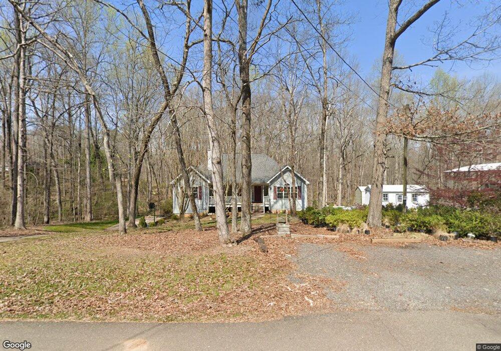
3565 Tallant Dr Cumming, GA 30028
Estimated Value: $397,000 - $429,000
3
Beds
2
Baths
1,721
Sq Ft
$240/Sq Ft
Est. Value
About This Home
This home is located at 3565 Tallant Dr, Cumming, GA 30028 and is currently estimated at $412,893, approximately $239 per square foot. 3565 Tallant Dr is a home located in Forsyth County with nearby schools including Poole's Mill Elementary School, Liberty Middle School, and North Forsyth High School.
Ownership History
Date
Name
Owned For
Owner Type
Purchase Details
Closed on
Mar 15, 1999
Sold by
Collins Amelia
Bought by
Collins Amelia D and Collins Joseph
Current Estimated Value
Home Financials for this Owner
Home Financials are based on the most recent Mortgage that was taken out on this home.
Original Mortgage
$107,900
Interest Rate
6.74%
Mortgage Type
Construction
Create a Home Valuation Report for This Property
The Home Valuation Report is an in-depth analysis detailing your home's value as well as a comparison with similar homes in the area
Home Values in the Area
Average Home Value in this Area
Purchase History
| Date | Buyer | Sale Price | Title Company |
|---|---|---|---|
| Collins Amelia D | -- | -- | |
| Collins A D A | -- | -- |
Source: Public Records
Mortgage History
| Date | Status | Borrower | Loan Amount |
|---|---|---|---|
| Closed | Collins A D A | $107,900 |
Source: Public Records
Tax History Compared to Growth
Tax History
| Year | Tax Paid | Tax Assessment Tax Assessment Total Assessment is a certain percentage of the fair market value that is determined by local assessors to be the total taxable value of land and additions on the property. | Land | Improvement |
|---|---|---|---|---|
| 2025 | $559 | $163,264 | $42,008 | $121,256 |
| 2024 | $559 | $148,148 | $31,504 | $116,644 |
| 2023 | $457 | $143,432 | $33,928 | $109,504 |
| 2022 | $563 | $98,544 | $20,488 | $78,056 |
| 2021 | $2,449 | $98,544 | $20,488 | $78,056 |
| 2020 | $2,379 | $95,168 | $20,488 | $74,680 |
| 2019 | $2,261 | $89,240 | $15,936 | $73,304 |
| 2018 | $2,044 | $78,544 | $15,936 | $62,608 |
| 2017 | $1,902 | $71,696 | $14,420 | $57,276 |
| 2016 | $1,818 | $68,660 | $11,384 | $57,276 |
| 2015 | $1,821 | $68,660 | $11,384 | $57,276 |
| 2014 | $1,542 | $61,532 | $0 | $0 |
Source: Public Records
Map
Nearby Homes
- 3310 Hillshire Dr
- 3330 Summerpoint Crossing
- 3335 Hillshire Dr
- Harvard II Plan at Hillshire
- Hampton Plan at Hillshire
- Wesley Plan at Hillshire
- Longwood Plan at Hillshire
- Vanderbilt Plan at Hillshire
- 3350 Hillshire Dr
- 3435 Summerdale Walk
- 3330 Hillshire Dr
- 2785 Marie Way
- 2775 Marie Way
- 3375 Hillshire Dr
- 2765 Marie Way
- 3390 Hillshire Dr
- 2755 Marie Way
- 3675 Summerpoint Crossing
- 2695 Marie Way
- 2725 Yellowstone Farm Dr
- 3565 Tallant Dr
- 3955 Raeburn Rd
- 3945 Raeburn Rd
- 3965 Raeburn Rd
- 3935 Raeburn Rd
- 3975 Raeburn Rd
- 3925 Raeburn Rd
- 3985 Raeburn Rd
- 4015 Raeburn Rd
- 3915 Raeburn Rd
- 3905 Raeburn Rd
- 3995 Raeburn Rd
- 3890 Raeburn Rd
- 2625 Joseph Dr
- 3930 Sugarloaf Dr
- 3895 Raeburn Rd
- 3935 Sugarloaf Dr
- 3990 Raeburn Rd
- 4065 Raeburn Rd
- 4010 Raeburn Rd