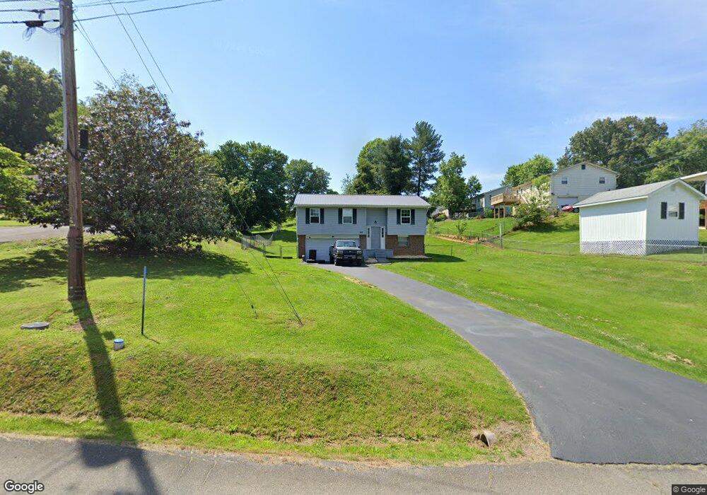
357 Rutledge St Bristol, TN 37620
Estimated Value: $227,000 - $266,286
4
Beds
2
Baths
1,545
Sq Ft
$159/Sq Ft
Est. Value
About This Home
This home is located at 357 Rutledge St, Bristol, TN 37620 and is currently estimated at $245,822, approximately $159 per square foot. 357 Rutledge St is a home located in Sullivan County with nearby schools including Bluff City Elementary School, Sullivan East Middle School, and Sullivan East High School.
Ownership History
Date
Name
Owned For
Owner Type
Purchase Details
Closed on
May 25, 2022
Sold by
Leonard Marshall S
Bought by
Hicks James C and Leonard Carrie L
Current Estimated Value
Home Financials for this Owner
Home Financials are based on the most recent Mortgage that was taken out on this home.
Original Mortgage
$86,000
Outstanding Balance
$81,225
Interest Rate
5.25%
Mortgage Type
New Conventional
Estimated Equity
$164,597
Purchase Details
Closed on
Jan 30, 2013
Sold by
Leonard Frances M
Bought by
Leonard Marshall S
Purchase Details
Closed on
Dec 5, 2002
Sold by
Seats Fleenor Betty Jo
Bought by
Leonard Frances M
Purchase Details
Closed on
Nov 6, 1989
Create a Home Valuation Report for This Property
The Home Valuation Report is an in-depth analysis detailing your home's value as well as a comparison with similar homes in the area
Purchase History
We collect this data history from publicly available records. To have your information removed, we recommend requesting removal directly through your county’s website.
| Date | Buyer | Sale Price | Title Company |
|---|---|---|---|
| Hicks James C | $64,154 | Evergreen Title | |
| Leonard Marshall S | -- | -- | |
| Leonard Frances M | $85,000 | -- | |
| -- | $42,000 | -- |
Source: Public Records
Mortgage History
We collect this data history from publicly available records. To have your information removed, we recommend requesting removal directly through your county’s website.
| Date | Status | Borrower | Loan Amount |
|---|---|---|---|
| Open | Hicks James C | $86,000 |
Source: Public Records
Tax History
| Year | Tax Paid | Tax Assessment Tax Assessment Total Assessment is a certain percentage of the fair market value that is determined by local assessors to be the total taxable value of land and additions on the property. | Land | Improvement |
|---|---|---|---|---|
| 2025 | $796 | $49,325 | $4,025 | $45,300 |
| 2024 | $640 | $25,650 | $3,300 | $22,350 |
| 2023 | $617 | $25,650 | $3,300 | $22,350 |
| 2022 | $617 | $25,650 | $3,300 | $22,350 |
| 2021 | $617 | $25,650 | $3,300 | $22,350 |
| 2020 | $623 | $25,650 | $3,300 | $22,350 |
| 2019 | $623 | $24,225 | $3,300 | $20,925 |
| 2018 | $618 | $24,225 | $3,300 | $20,925 |
| 2017 | $618 | $24,225 | $3,300 | $20,925 |
| 2016 | $653 | $25,350 | $3,300 | $22,050 |
| 2014 | $585 | $25,359 | $0 | $0 |
Source: Public Records
Map
Nearby Homes
- 1237 White Top Rd
- 465 Broyles Ln
- 305 Broyles Ln
- 1188 White Top Rd
- 464 Springfield Dr
- 361 Springfield Dr
- TBD Sweet Knobs Trail
- 257 Broyles Rd
- Tbd Sportsway Dr
- 228 Country Meadows Cir
- 229 Country Meadow Cir
- 717 White Top Rd
- 4118 Weaver Pike
- 4045 Weaver Pike
- 4463 Weaver Pike
- 413 Paddle Creek Rd
- 288 Brookside Ln
- 2315 Volunteer Pkwy
- 100 Richmond Heights Rd
- 1910 Riverside Rd
Your Personal Tour Guide
Ask me questions while you tour the home.