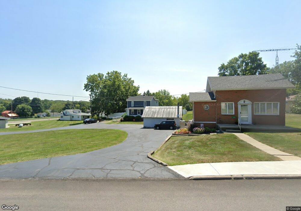
357 State Route 725 W Camden, OH 45311
Estimated Value: $199,000 - $257,000
3
Beds
2
Baths
1,792
Sq Ft
$124/Sq Ft
Est. Value
About This Home
This home is located at 357 State Route 725 W, Camden, OH 45311 and is currently estimated at $221,361, approximately $123 per square foot. 357 State Route 725 W is a home located in Preble County with nearby schools including Preble Shawnee Elementary School, West Elkton Intermediate School, and Preble Shawnee Junior/Senior High School.
Ownership History
Date
Name
Owned For
Owner Type
Purchase Details
Closed on
Sep 2, 1998
Sold by
Stubbs Robin G
Bought by
Brunner Trudy L
Current Estimated Value
Home Financials for this Owner
Home Financials are based on the most recent Mortgage that was taken out on this home.
Original Mortgage
$46,000
Outstanding Balance
$9,946
Interest Rate
7.04%
Mortgage Type
New Conventional
Estimated Equity
$211,415
Create a Home Valuation Report for This Property
The Home Valuation Report is an in-depth analysis detailing your home's value as well as a comparison with similar homes in the area
Home Values in the Area
Average Home Value in this Area
Purchase History
| Date | Buyer | Sale Price | Title Company |
|---|---|---|---|
| Brunner Trudy L | $96,000 | -- |
Source: Public Records
Mortgage History
| Date | Status | Borrower | Loan Amount |
|---|---|---|---|
| Open | Brunner Trudy L | $46,000 |
Source: Public Records
Tax History Compared to Growth
Tax History
| Year | Tax Paid | Tax Assessment Tax Assessment Total Assessment is a certain percentage of the fair market value that is determined by local assessors to be the total taxable value of land and additions on the property. | Land | Improvement |
|---|---|---|---|---|
| 2024 | $1,740 | $44,590 | $7,770 | $36,820 |
| 2023 | $1,740 | $44,590 | $7,770 | $36,820 |
| 2022 | $1,430 | $34,550 | $4,730 | $29,820 |
| 2021 | $1,587 | $34,550 | $4,730 | $29,820 |
| 2020 | $1,528 | $34,550 | $4,730 | $29,820 |
| 2019 | $1,202 | $25,660 | $4,730 | $20,930 |
| 2018 | $1,237 | $25,660 | $4,730 | $20,930 |
| 2017 | $1,137 | $25,660 | $4,730 | $20,930 |
| 2016 | $1,041 | $22,690 | $4,590 | $18,100 |
| 2014 | $1,081 | $22,690 | $4,590 | $18,100 |
| 2013 | $1,234 | $25,445 | $4,585 | $20,860 |
Source: Public Records
Map
Nearby Homes
- 388 W Hendricks St
- 407 W Central Ave
- 131 S Lafayette St
- 103 Katherine Ct
- 471 Camden West Elkton Rd
- 725 Sr
- 759 Barnetts Mill Rd
- 679 Oxford Germantown Rd
- 314 Lakengren Dr
- 1246 Oxford Germantown Rd
- 1222 Oxford Germantown Rd
- 0 Oxford Germantown Rd
- 820 Lars Cove
- 817 Old Norse Dr
- 0 Lars Cove Unit 1745954
- 805 Brande Dr
- 787 Baltic Dr
- 250 Lakengren Dr
- 0 Valhalla Cove Unit 941078
- 127 Voyage Dr
- 387 State Route 725 W
- 323 State Route 725 W
- 49 Douglas St
- 389 State Route 725 W
- 55 Douglas St
- 55 Douglas St
- 356 State Route 725 W
- 326 State Route 725 W
- 391 State Route 725 W
- 328 W Hendricks St
- 391 W Central Ave
- 318 State Route 725 W
- 407 E Central Ave
- 0 S 127 Us Route Unit 752046
- 0 N Us Rt 127 Unit 1402696
- 0 N Us Rt 127 Unit 1671945
- 0 U S 127
- 18 Acres U S 127
- 1 U S 127
- 393 State Route 725 W