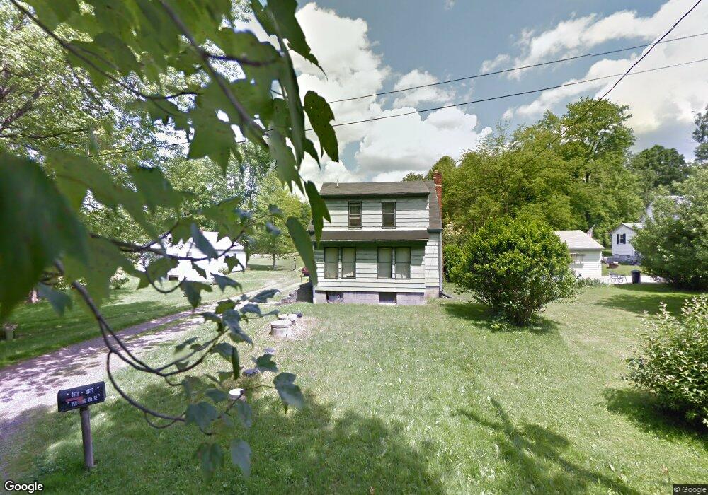
3573 Pershing Ave Hubbard, OH 44425
Estimated Value: $61,151 - $151,000
2
Beds
1
Bath
624
Sq Ft
$168/Sq Ft
Est. Value
About This Home
This home is located at 3573 Pershing Ave, Hubbard, OH 44425 and is currently estimated at $105,038, approximately $168 per square foot. 3573 Pershing Ave is a home located in Trumbull County with nearby schools including Hubbard Elementary School, Hubbard Middle School, and Hubbard High School.
Ownership History
Date
Name
Owned For
Owner Type
Purchase Details
Closed on
Jun 7, 2017
Sold by
Wright Paul Edward
Bought by
Brown David
Current Estimated Value
Purchase Details
Closed on
Jul 27, 2016
Sold by
Wright Anna Rebecca
Bought by
Paul Edward Wright
Home Financials for this Owner
Home Financials are based on the most recent Mortgage that was taken out on this home.
Interest Rate
3.45%
Purchase Details
Closed on
Jan 1, 1990
Bought by
Anna Rebecca Wright
Create a Home Valuation Report for This Property
The Home Valuation Report is an in-depth analysis detailing your home's value as well as a comparison with similar homes in the area
Home Values in the Area
Average Home Value in this Area
Purchase History
| Date | Buyer | Sale Price | Title Company |
|---|---|---|---|
| Brown David | $62,500 | None Available | |
| Paul Edward Wright | -- | -- | |
| Anna Rebecca Wright | -- | -- |
Source: Public Records
Mortgage History
| Date | Status | Borrower | Loan Amount |
|---|---|---|---|
| Previous Owner | Paul Edward Wright | -- |
Source: Public Records
Tax History Compared to Growth
Tax History
| Year | Tax Paid | Tax Assessment Tax Assessment Total Assessment is a certain percentage of the fair market value that is determined by local assessors to be the total taxable value of land and additions on the property. | Land | Improvement |
|---|---|---|---|---|
| 2024 | $898 | $15,480 | $2,210 | $13,270 |
| 2023 | $898 | $15,480 | $2,210 | $13,270 |
| 2022 | $885 | $13,590 | $2,210 | $11,380 |
| 2021 | $889 | $13,590 | $2,210 | $11,380 |
| 2020 | $893 | $13,590 | $2,210 | $11,380 |
| 2019 | $870 | $12,540 | $2,210 | $10,330 |
| 2018 | $844 | $12,540 | $2,210 | $10,330 |
| 2017 | $842 | $12,540 | $2,210 | $10,330 |
| 2016 | $475 | $14,710 | $2,000 | $12,710 |
| 2015 | $476 | $14,710 | $2,000 | $12,710 |
| 2014 | $916 | $14,710 | $2,000 | $12,710 |
| 2013 | $955 | $15,370 | $2,000 | $13,370 |
Source: Public Records
Map
Nearby Homes
- 3687 Franklin Ave
- 6287 Youngstown Hubbard Rd
- 366 Westview Ave
- 5843 Fairlawn Ave
- 3234 Bell Wick Rd
- V/L Jacobs Rd
- 652 Meadowland Dr
- 191 Maple Leaf Dr
- 124 Rebecca Ave
- 3943 Logangate Rd
- 2160 Lansdowne Blvd
- 323 W Liberty St
- 160 Hager St
- 203 Hager St
- 0 Homestead Rd
- 3244 Nelson Ave
- 185 Somerset Dr Unit 2
- 0 Powder Mill Run Unit 5127333
- 0 Powder Mill Run Unit 5127327
- 2824 Benford Ln
- 6143 Fairlawn Ave
- 3560 Woodbine Ave
- 3598 Woodbine Ave
- 6171 Fairlawn Ave
- 3565 Woodbine Ave
- 3536 Woodbine Ave
- 3608 Woodbine Ave
- 6181 Fairlawn Ave
- 3547 Woodbine Ave
- 6180 Highlawn Ave
- 3615 Woodbine Ave
- 6180 Fairlawn Ave
- 6199 Fairlawn Ave
- 3531 Woodbine Ave
- 6173 Ridge Ave
- 3524 Woodbine Ave
- 3524 Woodbine Ave
- 6192 Fairlawn Ave
- 3525 Woodbine Ave
- 3636 Woodbine Ave