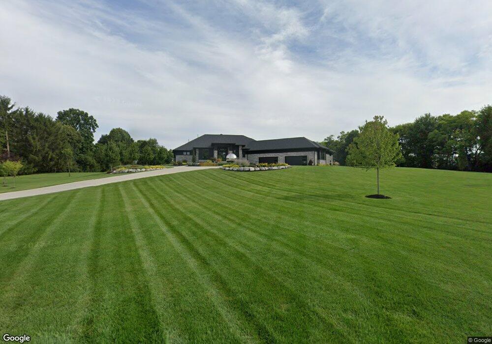
3584 Swigart Rd Dayton, OH 45440
Estimated Value: $606,000 - $1,813,651
4
Beds
6
Baths
4,121
Sq Ft
$246/Sq Ft
Est. Value
About This Home
This home is located at 3584 Swigart Rd, Dayton, OH 45440 and is currently estimated at $1,012,550, approximately $245 per square foot. 3584 Swigart Rd is a home with nearby schools including Fairbrook Elementary School, Herman K Ankeney Middle School, and Beavercreek High School.
Ownership History
Date
Name
Owned For
Owner Type
Purchase Details
Closed on
Jul 22, 2021
Sold by
Human Mark E and Human Kimberly D
Bought by
Human Mark E and Human Kimberly D
Current Estimated Value
Purchase Details
Closed on
Dec 2, 2020
Sold by
Chong David A and Chong Diane M
Bought by
Human Mark E and Human Kimberly D
Purchase Details
Closed on
Sep 16, 2002
Sold by
Bayman H Duane
Bought by
Chong David A and Chong Diane M
Purchase Details
Closed on
Nov 1, 1999
Sold by
Duane Bayman H
Bought by
Bayman H Duane and H Duane Bayman Revocable Living Trust
Create a Home Valuation Report for This Property
The Home Valuation Report is an in-depth analysis detailing your home's value as well as a comparison with similar homes in the area
Home Values in the Area
Average Home Value in this Area
Purchase History
| Date | Buyer | Sale Price | Title Company |
|---|---|---|---|
| Human Mark E | -- | None Available | |
| Human Mark E | $200,000 | Triad Title Agency Inc | |
| Chong David A | $125,000 | -- | |
| Bayman H Duane | -- | -- |
Source: Public Records
Tax History Compared to Growth
Tax History
| Year | Tax Paid | Tax Assessment Tax Assessment Total Assessment is a certain percentage of the fair market value that is determined by local assessors to be the total taxable value of land and additions on the property. | Land | Improvement |
|---|---|---|---|---|
| 2024 | $30,729 | $380,040 | $67,520 | $312,520 |
| 2023 | $30,729 | $380,040 | $67,520 | $312,520 |
| 2022 | $5,280 | $70,000 | $70,000 | $0 |
| 2021 | $5,176 | $70,000 | $70,000 | $0 |
| 2020 | $2,030 | $24,870 | $24,870 | $0 |
| 2019 | $2,030 | $24,870 | $24,870 | $0 |
| 2018 | $1,796 | $24,870 | $24,870 | $0 |
| 2017 | $1,854 | $24,870 | $24,870 | $0 |
| 2016 | $1,855 | $24,870 | $24,870 | $0 |
| 2015 | $922 | $24,870 | $24,870 | $0 |
| 2014 | $909 | $24,870 | $24,870 | $0 |
Source: Public Records
Map
Nearby Homes
- 149 Chartley Ct
- 70 Larchmere Dr
- 197 Bramblebush Trail
- 185 Bramblebush Trail
- 281 Locust Ct
- 332 Skyland Dr
- 91 Cherry Hill Dr
- 264 S Alpha Bellbrook Rd
- 454 Skyland Dr
- 3908 Barrymore Ln
- 3878 Pepperwell Cir
- 3899 Pepperwell Cir
- 679 S Alpha Bellbrook Rd
- 3597 Echo Hill Ln
- 3109 Indian Ripple Rd
- 3211 Tarleton Dr
- 717 S Alpha Bellbrook Rd
- 3978 Indian Ripple Rd
- 24 Rosell Dr
- 3682 Echo Hill Ln
- 3548 Swigart Rd
- 3558 Swigart Rd
- 3536 Swigart Rd
- 3568 Swigart Rd
- 3523 High Point Ct
- 3524 Swigart Rd
- 3535 High Point Ct
- 3515 High Point Ct
- 3535 Swigart Rd
- 3509 High Point Ct
- 3510 Swigart Rd
- 3543 High Point Ct
- 3557 Swigart Rd
- 3505 High Point Ct
- 3526 High Point Ct
- 3518 High Point Ct
- 3536 High Point Ct
- 3585 Swigart Rd
- 3511 Swigart Rd
- 3512 High Point Ct