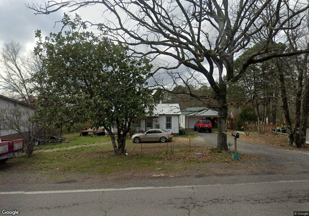
3586 Highway 330 S Shirley, AR 72153
Estimated Value: $63,000 - $181,000
--
Bed
1
Bath
1,008
Sq Ft
$113/Sq Ft
Est. Value
About This Home
This home is located at 3586 Highway 330 S, Shirley, AR 72153 and is currently estimated at $114,060, approximately $113 per square foot. 3586 Highway 330 S is a home located in Van Buren County with nearby schools including Shirley Elementary School and Shirley High School.
Ownership History
Date
Name
Owned For
Owner Type
Purchase Details
Closed on
Jun 20, 2018
Sold by
Hunt Ben G and Hunt Ben G
Bought by
Jones Bobby Lawson
Current Estimated Value
Home Financials for this Owner
Home Financials are based on the most recent Mortgage that was taken out on this home.
Original Mortgage
$25,500
Outstanding Balance
$22,053
Interest Rate
4.5%
Mortgage Type
New Conventional
Estimated Equity
$92,007
Purchase Details
Closed on
Aug 21, 2000
Sold by
Clutts Evlene
Bought by
Hunt Ben G and Hunt Veatrice
Purchase Details
Closed on
Oct 25, 1967
Bought by
Clutts Evlene
Create a Home Valuation Report for This Property
The Home Valuation Report is an in-depth analysis detailing your home's value as well as a comparison with similar homes in the area
Home Values in the Area
Average Home Value in this Area
Purchase History
| Date | Buyer | Sale Price | Title Company |
|---|---|---|---|
| Jones Bobby Lawson | $30,500 | Cannaday Abstract | |
| Hunt Ben G | -- | None Available | |
| Clutts Evlene | -- | -- |
Source: Public Records
Mortgage History
| Date | Status | Borrower | Loan Amount |
|---|---|---|---|
| Open | Jones Bobby Lawson | $25,500 |
Source: Public Records
Tax History Compared to Growth
Tax History
| Year | Tax Paid | Tax Assessment Tax Assessment Total Assessment is a certain percentage of the fair market value that is determined by local assessors to be the total taxable value of land and additions on the property. | Land | Improvement |
|---|---|---|---|---|
| 2024 | $277 | $6,480 | $600 | $5,880 |
| 2023 | $277 | $6,480 | $600 | $5,880 |
| 2022 | $245 | $6,480 | $600 | $5,880 |
| 2021 | $245 | $6,480 | $600 | $5,880 |
| 2020 | $245 | $6,480 | $600 | $5,880 |
| 2019 | $245 | $5,720 | $600 | $5,120 |
| 2018 | $245 | $5,720 | $600 | $5,120 |
| 2017 | $224 | $5,720 | $600 | $5,120 |
| 2015 | -- | $4,410 | $600 | $3,810 |
| 2014 | -- | $4,410 | $600 | $3,810 |
| 2013 | -- | $4,410 | $600 | $3,810 |
Source: Public Records
Map
Nearby Homes
- 27.46 Acres Highway 330 S
- 27.46 Highway 330 S
- Lot 55 White Oak Dr
- 224 Chalet Cir
- 0 Owen Circles
- 106 Rainbow Ct
- 00 Lakeside Dr
- Lot 29 Block 1 Highland Dr
- 112 Chalet Cir
- 0 Corner of Hwy 330 S and Garner Ln Unit 24045956
- Lot 40 Greenwood Dr
- 102 Fireside Ln
- 0 Corner of Hwy 330 & New Rd Unit 24045954
- Lot 53 Block 6 Cedar Valley Cir
- 00 W Cliff Dr
- Lot 61 W Cliff Dr
- Lot 143 Block 4 W Cliff Dr
- Lot 51 W Cliff Dr
- Lot 51 Block 1 W Cliff Dr
- 2525 Mountain Park Rd
- 3630 Highway 330 S
- 3619 Highway 330 S
- 3556 Highway 330 S
- 0 Hwy 330 Unit 20022080
- 3611 Highway 330 S
- 3687 Highway 330 S
- 3593 Highway 330 S
- 3455 Highway 330 S
- 3796 Highway 330 S
- 3587 Highway 330 S
- 3351 Highway 330 S
- 3351 Highway 330 S
- 3334 Highway 330 S
- 298 Eglantine Rd
- 274 Eglantine Rd
- 534 W Cliff Dr
- 606 W Cliff Dr
- 300 Eglantine Rd
- 155 White Oak Dr
- 3284 Highway 330 S