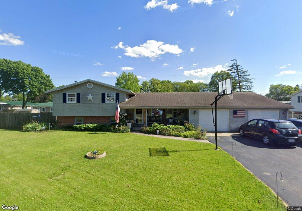
359 Arch Dr Bucyrus, OH 44820
Estimated Value: $189,257 - $248,000
3
Beds
1
Bath
1,806
Sq Ft
$123/Sq Ft
Est. Value
About This Home
This home is located at 359 Arch Dr, Bucyrus, OH 44820 and is currently estimated at $222,314, approximately $123 per square foot. 359 Arch Dr is a home located in Crawford County with nearby schools including Bucyrus Elementary School, Bucyrus Secondary School, and CENTER FOR AUTISM / DYSLEXIA - BUCYRUS.
Ownership History
Date
Name
Owned For
Owner Type
Purchase Details
Closed on
Feb 17, 2009
Sold by
Fannie Mae
Bought by
Wells Michael E
Current Estimated Value
Home Financials for this Owner
Home Financials are based on the most recent Mortgage that was taken out on this home.
Original Mortgage
$88,369
Outstanding Balance
$55,979
Interest Rate
5.14%
Mortgage Type
FHA
Estimated Equity
$166,335
Create a Home Valuation Report for This Property
The Home Valuation Report is an in-depth analysis detailing your home's value as well as a comparison with similar homes in the area
Home Values in the Area
Average Home Value in this Area
Purchase History
| Date | Buyer | Sale Price | Title Company |
|---|---|---|---|
| Wells Michael E | $90,000 | -- |
Source: Public Records
Mortgage History
| Date | Status | Borrower | Loan Amount |
|---|---|---|---|
| Open | Wells Michael E | $88,369 |
Source: Public Records
Tax History Compared to Growth
Tax History
| Year | Tax Paid | Tax Assessment Tax Assessment Total Assessment is a certain percentage of the fair market value that is determined by local assessors to be the total taxable value of land and additions on the property. | Land | Improvement |
|---|---|---|---|---|
| 2024 | $2,197 | $50,000 | $5,610 | $44,390 |
| 2023 | $2,197 | $38,460 | $4,350 | $34,110 |
| 2022 | $1,999 | $38,460 | $4,350 | $34,110 |
| 2021 | $1,995 | $38,460 | $4,350 | $34,110 |
| 2020 | $1,674 | $30,590 | $4,350 | $26,240 |
| 2019 | $1,711 | $30,590 | $4,350 | $26,240 |
| 2018 | $1,703 | $30,590 | $4,350 | $26,240 |
| 2017 | $1,692 | $29,330 | $4,350 | $24,980 |
| 2016 | $1,639 | $29,330 | $4,350 | $24,980 |
| 2015 | $1,615 | $29,330 | $4,350 | $24,980 |
| 2014 | $1,608 | $29,330 | $4,350 | $24,980 |
| 2013 | $1,608 | $29,330 | $4,350 | $24,980 |
Source: Public Records
Map
Nearby Homes
- 1258 S Sandusky Ave
- 1211 S Sandusky Ave
- 0 Lynne Ave
- 1021 S Sandusky Ave
- 1145 Lynne Ave
- 137 Wallace Ave
- 900 S Spring St
- 1112 Hillcrest Dr
- 1123 Hillcrest Dr
- 221 W Oakwood Ave
- 823 S Walnut St
- 703 S Poplar St
- 622 S Poplar St
- 427 E Southern Ave
- 325 W Liberty St
- 2440 Wyandot Rd
- 419 Short St
- 531 S Poplar St
- 275 Brentwood St
- 550 S Walnut St
- 369 Arch Dr
- 349 Arch Dr
- 32 Pinewood
- 354 Arch Dr
- 350 Arch Dr
- 0 Pinewood Apartments 32 Pinewood Ct Unit 7629220-11811952
- 0 Pinewood Apartments 32 Pinewood Ct Unit 7629220-11382647
- 370 Arch Dr
- 340 Arch Dr
- 321 Arch Dr
- 375 Arch Dr
- 1500 Marion Rd
- 330 Arch Dr
- 319 Arch Dr
- 1401 Marion Rd
- 1375 Marion Rd
- 1400 Marion Rd
- 700 Sunset Dr
- 320 Arch Dr
- 404 W Beal Ave