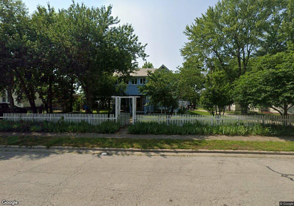
359 Bland Ave Lebanon, MO 65536
Estimated Value: $207,000 - $272,000
3
Beds
1
Bath
2,298
Sq Ft
$100/Sq Ft
Est. Value
About This Home
This home is located at 359 Bland Ave, Lebanon, MO 65536 and is currently estimated at $230,655, approximately $100 per square foot. 359 Bland Ave is a home located in Laclede County with nearby schools including Joe D. Esther Elementary School, Boswell Elementary School, and Maplecrest Elementary School.
Ownership History
Date
Name
Owned For
Owner Type
Purchase Details
Closed on
Jun 18, 2024
Sold by
Ise Investments Llc and Hogan Land Title
Bought by
Us Bank National Association
Current Estimated Value
Purchase Details
Closed on
Feb 24, 2021
Sold by
Miller Leana R
Bought by
Miller Robert L
Purchase Details
Closed on
Dec 21, 2011
Sold by
Ross Alan E
Bought by
Miller Robert and Miller Leana
Home Financials for this Owner
Home Financials are based on the most recent Mortgage that was taken out on this home.
Original Mortgage
$56,529
Interest Rate
4.03%
Mortgage Type
FHA
Create a Home Valuation Report for This Property
The Home Valuation Report is an in-depth analysis detailing your home's value as well as a comparison with similar homes in the area
Home Values in the Area
Average Home Value in this Area
Purchase History
| Date | Buyer | Sale Price | Title Company |
|---|---|---|---|
| Us Bank National Association | $91,960 | None Listed On Document | |
| Miller Robert L | -- | None Available | |
| Miller Robert | -- | None Available |
Source: Public Records
Mortgage History
| Date | Status | Borrower | Loan Amount |
|---|---|---|---|
| Previous Owner | Miller Robert | $56,529 |
Source: Public Records
Tax History Compared to Growth
Tax History
| Year | Tax Paid | Tax Assessment Tax Assessment Total Assessment is a certain percentage of the fair market value that is determined by local assessors to be the total taxable value of land and additions on the property. | Land | Improvement |
|---|---|---|---|---|
| 2025 | $1,215 | $24,050 | $0 | $0 |
| 2024 | $1,215 | $21,300 | $0 | $0 |
| 2023 | $1,252 | $21,320 | $0 | $0 |
| 2022 | $1,167 | $21,320 | $0 | $0 |
| 2021 | $1,286 | $21,318 | $1,672 | $19,646 |
| 2020 | $950 | $15,675 | $1,672 | $14,003 |
| 2019 | $782 | $13,470 | $1,670 | $11,800 |
| 2018 | $734 | $13,470 | $1,670 | $11,800 |
| 2017 | $545 | $13,470 | $0 | $0 |
| 2016 | $545 | $10,550 | $0 | $0 |
| 2015 | $545 | $10,550 | $0 | $0 |
| 2014 | $545 | $10,550 | $0 | $0 |
| 2013 | -- | $10,550 | $0 | $0 |
Source: Public Records
Map
Nearby Homes
- 0 County Rd 64-152 N A
- 169 Grand Ave
- 595 Chestnut St
- 371 N Washington Ave
- Lot 20 Missouri 64
- 1719 State Hwy 64
- 015 Missouri 64
- Lot 19 Missouri 64
- Lot 18 Missouri 64
- Lot 17 Missouri 64
- 014 Missouri 64
- 016 Missouri 64
- 540 Pearl St
- 377 Lincoln Ave
- 411 South St
- 440 Railroad Ave
- 480 Center Ave
- 757 S Adams Ave
- 406 Perry St
- 466 Lynn St