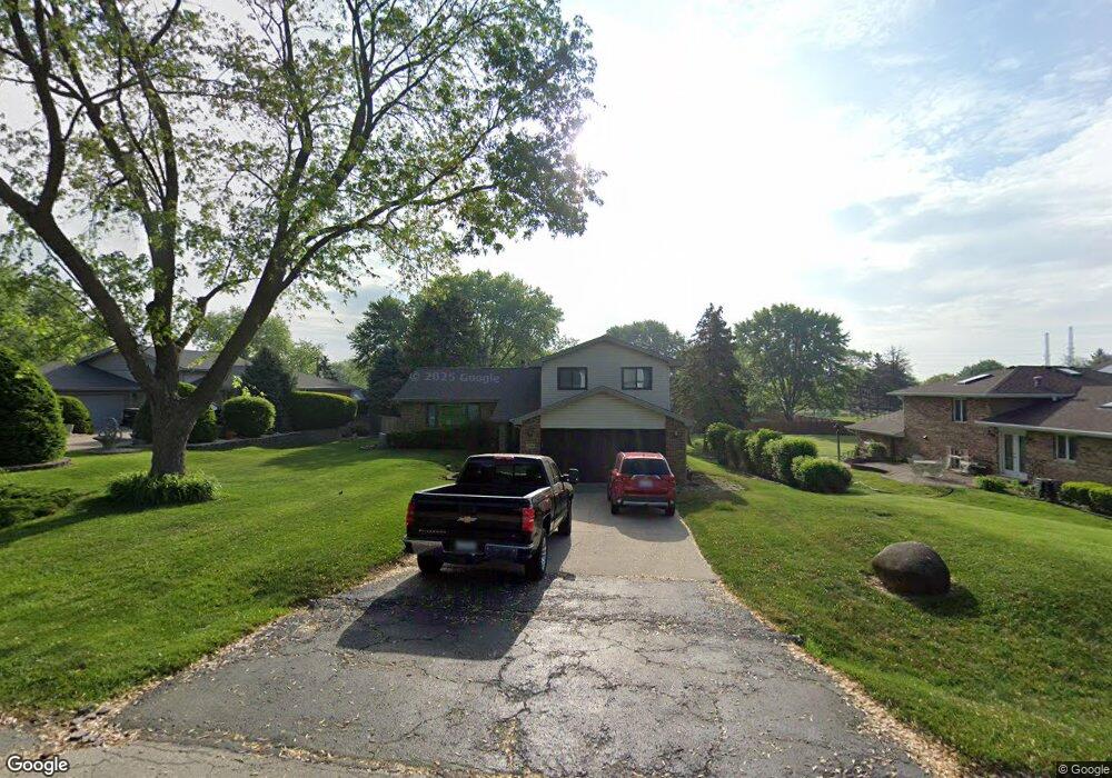
359 De Paul Ct Unit 2 Romeoville, IL 60446
Estimated Value: $317,000 - $338,000
--
Bed
--
Bath
1,853
Sq Ft
$177/Sq Ft
Est. Value
About This Home
This home is located at 359 De Paul Ct Unit 2, Romeoville, IL 60446 and is currently estimated at $327,500, approximately $176 per square foot. 359 De Paul Ct Unit 2 is a home located in Will County with nearby schools including Robert C. Hill Elementary School, A. Vito Martinez Middle School, and Romeoville High School.
Ownership History
Date
Name
Owned For
Owner Type
Purchase Details
Closed on
Dec 14, 1995
Sold by
Dzik Michael P and Dzik Paula
Bought by
Guilbo Michael J and Guilbo Sally J
Current Estimated Value
Home Financials for this Owner
Home Financials are based on the most recent Mortgage that was taken out on this home.
Original Mortgage
$132,000
Interest Rate
7.41%
Purchase Details
Closed on
Jul 27, 1995
Sold by
Oslakovic Gerald J and Oslakovic Robert F
Bought by
Dzik Michael P and Dzik Paula
Home Financials for this Owner
Home Financials are based on the most recent Mortgage that was taken out on this home.
Original Mortgage
$100,000
Interest Rate
7.51%
Create a Home Valuation Report for This Property
The Home Valuation Report is an in-depth analysis detailing your home's value as well as a comparison with similar homes in the area
Home Values in the Area
Average Home Value in this Area
Purchase History
| Date | Buyer | Sale Price | Title Company |
|---|---|---|---|
| Guilbo Michael J | $165,000 | -- | |
| Dzik Michael P | $75,000 | Chicago Title Insurance Co |
Source: Public Records
Mortgage History
| Date | Status | Borrower | Loan Amount |
|---|---|---|---|
| Closed | Guilbo Michael J | $132,000 | |
| Previous Owner | Dzik Michael P | $100,000 |
Source: Public Records
Tax History Compared to Growth
Tax History
| Year | Tax Paid | Tax Assessment Tax Assessment Total Assessment is a certain percentage of the fair market value that is determined by local assessors to be the total taxable value of land and additions on the property. | Land | Improvement |
|---|---|---|---|---|
| 2024 | $9,131 | $112,270 | $32,117 | $80,153 |
| 2023 | $9,131 | $101,017 | $28,898 | $72,119 |
| 2022 | $8,920 | $101,191 | $28,948 | $72,243 |
| 2021 | $8,478 | $94,615 | $27,067 | $67,548 |
| 2020 | $8,256 | $91,504 | $26,177 | $65,327 |
| 2019 | $7,858 | $87,146 | $24,930 | $62,216 |
| 2018 | $7,571 | $83,209 | $23,861 | $59,348 |
| 2017 | $7,834 | $85,721 | $24,582 | $61,139 |
| 2016 | $7,540 | $81,600 | $23,400 | $58,200 |
| 2015 | $6,527 | $78,200 | $22,400 | $55,800 |
| 2014 | $6,527 | $78,200 | $22,400 | $55,800 |
| 2013 | $6,527 | $71,100 | $20,400 | $50,700 |
Source: Public Records
Map
Nearby Homes
- 371 N Independence Blvd
- 228 Gordon Ave
- 216 Hayes Ave
- 221 Murphy Dr
- 204 Healy Ave
- 413 Glen Ave
- 426 Holden Ave
- 343 Hale Ave
- 310 Haller Ave
- 242 Tallman Ave
- 321 Haller Ave
- 408 Haller Ave
- 613 Jordan Ave
- 605 Montrose Dr
- 0 N Weber Rd Unit MRD12364369
- Lot 2 Governors Hwy
- 436 Clifton Ave
- 700 Normantown Rd
- 637 Kingston Dr
- 312 Fremont Ave