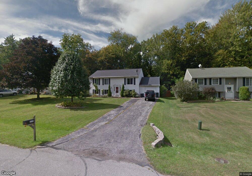
359 Manhattan Pkwy Painesville, OH 44077
Estimated Value: $251,615 - $306,000
4
Beds
2
Baths
2,080
Sq Ft
$134/Sq Ft
Est. Value
About This Home
This home is located at 359 Manhattan Pkwy, Painesville, OH 44077 and is currently estimated at $278,904, approximately $134 per square foot. 359 Manhattan Pkwy is a home located in Lake County with nearby schools including Henry F. Lamuth Middle School, Riverside Junior/Senior High School, and Summit Academy Community School - Painesville.
Ownership History
Date
Name
Owned For
Owner Type
Purchase Details
Closed on
Jun 25, 2018
Sold by
Guthrie Stephanie and Guthrie Michael David
Bought by
Guthrie Michael David
Current Estimated Value
Purchase Details
Closed on
Jun 29, 2010
Sold by
Morris Regina M and Morris Timothy S
Bought by
Guthrie Michael David
Home Financials for this Owner
Home Financials are based on the most recent Mortgage that was taken out on this home.
Original Mortgage
$162,679
Outstanding Balance
$108,910
Interest Rate
4.87%
Mortgage Type
FHA
Estimated Equity
$169,994
Purchase Details
Closed on
Oct 19, 2000
Sold by
Bidlack Thomas E and Bidlack Melinda R
Bought by
Morris Regina M
Home Financials for this Owner
Home Financials are based on the most recent Mortgage that was taken out on this home.
Original Mortgage
$117,540
Interest Rate
7.96%
Mortgage Type
FHA
Purchase Details
Closed on
Jul 12, 1985
Bought by
Bidlack Thomas E
Create a Home Valuation Report for This Property
The Home Valuation Report is an in-depth analysis detailing your home's value as well as a comparison with similar homes in the area
Home Values in the Area
Average Home Value in this Area
Purchase History
| Date | Buyer | Sale Price | Title Company |
|---|---|---|---|
| Guthrie Michael David | -- | None Available | |
| Guthrie Michael David | $164,900 | First Usa Title Agency Lp | |
| Morris Regina M | $117,600 | Chicago Title Insurance Comp | |
| Bidlack Thomas E | -- | -- |
Source: Public Records
Mortgage History
| Date | Status | Borrower | Loan Amount |
|---|---|---|---|
| Open | Guthrie Michael David | $162,679 | |
| Previous Owner | Morris Regina M | $117,540 |
Source: Public Records
Tax History Compared to Growth
Tax History
| Year | Tax Paid | Tax Assessment Tax Assessment Total Assessment is a certain percentage of the fair market value that is determined by local assessors to be the total taxable value of land and additions on the property. | Land | Improvement |
|---|---|---|---|---|
| 2024 | -- | $72,310 | $17,600 | $54,710 |
| 2023 | $6,050 | $55,520 | $14,150 | $41,370 |
| 2022 | $3,256 | $55,520 | $14,150 | $41,370 |
| 2021 | $3,268 | $55,520 | $14,150 | $41,370 |
| 2020 | $3,219 | $48,270 | $12,300 | $35,970 |
| 2019 | $3,243 | $48,270 | $12,300 | $35,970 |
| 2018 | $3,253 | $46,620 | $10,350 | $36,270 |
| 2017 | $3,236 | $46,620 | $10,350 | $36,270 |
| 2016 | $2,849 | $46,620 | $10,350 | $36,270 |
| 2015 | $2,669 | $46,620 | $10,350 | $36,270 |
| 2014 | $2,713 | $46,620 | $10,350 | $36,270 |
| 2013 | $2,651 | $46,620 | $10,350 | $36,270 |
Source: Public Records
Map
Nearby Homes
- 396 Park Rd
- 500 Park Rd
- V/L Morgan Dr
- 525 Morgan Dr
- 43 Bristol Ave
- 67 Tanners Farm Dr
- 65 Tanners Farm Dr
- 269 Hale Rd
- 1182 Dalton Dr
- 1172 Dalton Dr
- 108 Birch Dr
- 5406 Pebble Creek Ln
- 4505 Lane Rd
- 1787 Muirfield Ln
- 0 N Ridge Rd Unit 5110949
- 44 Grove Ave
- 30 Orton Rd
- 58 Deerfield Dr
- 389 Sand Trap Cir
- 1598 Bogie Ln
- 351 Manhattan Pkwy
- 365 Manhattan Pkwy
- 343 Manhattan Pkwy
- 373 Manhattan Pkwy
- 356 Manhattan Pkwy
- 381 Manhattan Pkwy
- 335 Manhattan Pkwy
- 370 Manhattan Pkwy
- 348 Manhattan Pkwy
- 391 Manhattan Pkwy
- 329 Manhattan Pkwy
- 380 Manhattan Pkwy
- 1581 Queens Ct
- 397 Manhattan Pkwy
- 388 Manhattan Pkwy
- 1586 Greenwich Ct
- 1595 Greenwich Ct
- 1596 Greenwich Ct
- 1589 Greenwich Ct
- 1589 Queens Ct