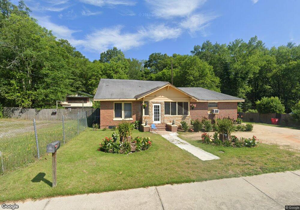
3591 Log Cabin Dr Macon, GA 31204
Estimated Value: $80,833 - $134,000
4
Beds
1
Bath
1,636
Sq Ft
$60/Sq Ft
Est. Value
About This Home
This home is located at 3591 Log Cabin Dr, Macon, GA 31204 and is currently estimated at $98,958, approximately $60 per square foot. 3591 Log Cabin Dr is a home located in Bibb County with nearby schools including Union Elementary School, Weaver Middle School, and Westside High School.
Ownership History
Date
Name
Owned For
Owner Type
Purchase Details
Closed on
Jun 10, 2025
Sold by
Mathis Carla and Causey Carla Renee
Bought by
Causey Carla Renee
Current Estimated Value
Purchase Details
Closed on
Jul 1, 2017
Sold by
Rowland Cort
Bought by
Mathis Carla
Purchase Details
Closed on
Apr 16, 2010
Sold by
Capital City Bank
Bought by
Rowland Cort
Purchase Details
Closed on
Nov 13, 2009
Sold by
Alliance Properties Georgia Llc
Bought by
Capital City Bank
Create a Home Valuation Report for This Property
The Home Valuation Report is an in-depth analysis detailing your home's value as well as a comparison with similar homes in the area
Purchase History
| Date | Buyer | Sale Price | Title Company |
|---|---|---|---|
| Causey Carla Renee | -- | None Listed On Document | |
| Causey Carla Renee | -- | None Listed On Document | |
| Mathis Carla | -- | None Available | |
| Rowland Cort | $10,475 | None Available | |
| Capital City Bank | $170,000 | None Available |
Source: Public Records
Tax History
| Year | Tax Paid | Tax Assessment Tax Assessment Total Assessment is a certain percentage of the fair market value that is determined by local assessors to be the total taxable value of land and additions on the property. | Land | Improvement |
|---|---|---|---|---|
| 2025 | $366 | $21,897 | $4,000 | $17,897 |
| 2024 | $378 | $21,897 | $4,000 | $17,897 |
| 2023 | $441 | $21,897 | $4,000 | $17,897 |
| 2022 | $117 | $10,382 | $3,684 | $6,698 |
| 2021 | $129 | $10,382 | $3,684 | $6,698 |
| 2020 | $131 | $10,382 | $3,684 | $6,698 |
| 2019 | $132 | $10,382 | $3,684 | $6,698 |
| 2018 | $383 | $10,382 | $3,684 | $6,698 |
| 2017 | $389 | $10,382 | $3,684 | $6,698 |
| 2016 | $359 | $10,382 | $3,684 | $6,698 |
| 2015 | $705 | $14,402 | $3,684 | $10,717 |
| 2014 | $802 | $14,402 | $3,684 | $10,717 |
Source: Public Records
Map
Nearby Homes
- 3890 Robinson Rd
- 3483 Napier Ave
- 3491 Bond St W
- 3778 Log Cabin Dr
- 3442 Walker St
- 3457 Shenandoah Dr
- 1184 Edna Place
- 3340 Napier Ave
- 1055 Lamont St
- 961 Log Cabin Way
- 3435 Hillcrest Rd
- 3454 Lawton Rd
- 1077 Pike St
- 3462 Lawton Rd
- 3483 Lawton Rd
- 3529 Thorpe St
- 3470 Lawton Rd
- 3765 Del Park
- 3816 Log Cabin Dr
- 4226 Robinson Cir
- 3611 Log Cabin Dr
- 3577 Log Cabin Dr
- 3619 Log Cabin Dr
- 3575 Log Cabin Dr
- 3588 Log Cabin Dr
- 3627 Log Cabin Dr
- 3603 Log Cabin Dr
- 3580 Log Cabin Dr
- 3571 Log Cabin Dr
- 3576 Log Cabin Dr
- 3643 Log Cabin Dr
- 3635 Log Cabin Dr
- 3568 Log Cabin Dr
- 3651 Log Cabin Dr
- 3557 Log Cabin Dr
- 3564 Log Cabin Dr
- 3659 Log Cabin Dr
- 1088 Scotland Ave
- 3560 Log Cabin Dr
- 3652 Log Cabin Dr
Your Personal Tour Guide
Ask me questions while you tour the home.