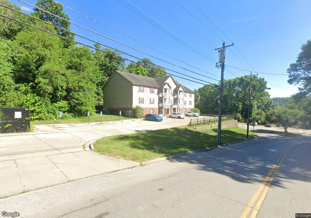
36 Anderson Ferry Rd Cincinnati, OH 45238
Riverside Sedamsville Neighborhood
3
Beds
1
Bath
13,824
Sq Ft
304,920
Sq Ft Lot
About This Home
This home is located at 36 Anderson Ferry Rd, Cincinnati, OH 45238. 36 Anderson Ferry Rd is a home located in Hamilton County with nearby schools including Sayler Park Elementary School, Gilbert A. Dater High School, and Western Hills High School.
Ownership History
Date
Name
Owned For
Owner Type
Purchase Details
Closed on
Sep 25, 2012
Sold by
Db Capers Llc
Bought by
Cincinnati Metropolitan Housing Authorit
Purchase Details
Closed on
May 4, 2010
Sold by
Roark Development Llc
Bought by
Db Capers Llc
Purchase Details
Closed on
Dec 13, 1999
Sold by
Wayne Randy M and Wayne Randy
Bought by
Roark Development Llc
Purchase Details
Closed on
Nov 29, 1999
Sold by
Benjey Anna M and Wayne Anna M
Bought by
Wayne Randy M
Create a Home Valuation Report for This Property
The Home Valuation Report is an in-depth analysis detailing your home's value as well as a comparison with similar homes in the area
Home Values in the Area
Average Home Value in this Area
Purchase History
| Date | Buyer | Sale Price | Title Company |
|---|---|---|---|
| Cincinnati Metropolitan Housing Authorit | -- | Attorney | |
| Db Capers Llc | -- | Attorney | |
| Roark Development Llc | $75,000 | -- | |
| Wayne Randy M | -- | -- |
Source: Public Records
Tax History
| Year | Tax Paid | Tax Assessment Tax Assessment Total Assessment is a certain percentage of the fair market value that is determined by local assessors to be the total taxable value of land and additions on the property. | Land | Improvement |
|---|---|---|---|---|
| 2025 | -- | $199,648 | $10,658 | $188,990 |
| 2023 | $0 | $199,648 | $10,658 | $188,990 |
| 2022 | $0 | $209,077 | $9,797 | $199,280 |
| 2021 | $74 | $209,077 | $9,797 | $199,280 |
| 2020 | $74 | $209,077 | $9,797 | $199,280 |
| 2019 | $74 | $209,077 | $9,797 | $199,280 |
| 2018 | $74 | $209,077 | $9,797 | $199,280 |
| 2017 | $67 | $209,077 | $9,797 | $199,280 |
| 2016 | $67 | $171,392 | $9,380 | $162,012 |
| 2015 | $67 | $171,392 | $9,380 | $162,012 |
| 2014 | $15,139 | $171,392 | $9,380 | $162,012 |
| 2013 | $17,239 | $194,762 | $10,658 | $184,104 |
Source: Public Records
Map
Nearby Homes
- 4904 Riverwatch Dr
- 298 Kinsman Ct
- 4186 River Rd
- 5062 Orangelawn Dr
- 4979 Bonaventure Ct
- 4231 River Rd Unit Parcel-A
- 4231 River Rd Unit Parcel-C
- 4231 River Rd Unit Parcel-B
- 4231 River Rd Unit Parcel-A-B-C
- 3938 Hillside Ave
- 3085 Point Pleasant Rd
- 3908 Pattison Ave
- 410 Morrvue Dr
- 4938 Mount Alverno Rd
- 337 Greenwell Ave
- 2752 River Birch Ln
- 481 Viscount Dr
- 2723 River Birch Dr
- 5210 Old Oak Trail
- 3744 Hillside Ave
- 39 Anderson Ferry Rd
- 37 Anderson Ferry Rd
- 41 Anderson Ferry Rd
- 43 Anderson Ferry Rd
- 4335 Hillside Ave
- 47 Anderson Ferry Rd
- 4315 Hillside Ave
- 4315 Hillside Ave Unit A
- 4290 Hillside Ave
- 4350 Hillside Ave
- 4350 Hillside Ave Unit A
- 4350 Hillside Ave Unit B
- 4350 Hillside Ave Unit C
- 4288 Hillside Ave
- 53 Anderson Ferry Rd
- 4316 River Rd
- 4355 Hillside Ave
- 4302 River Rd
- 4490 River Rd
- 4278 Hillside Ave
Your Personal Tour Guide
Ask me questions while you tour the home.