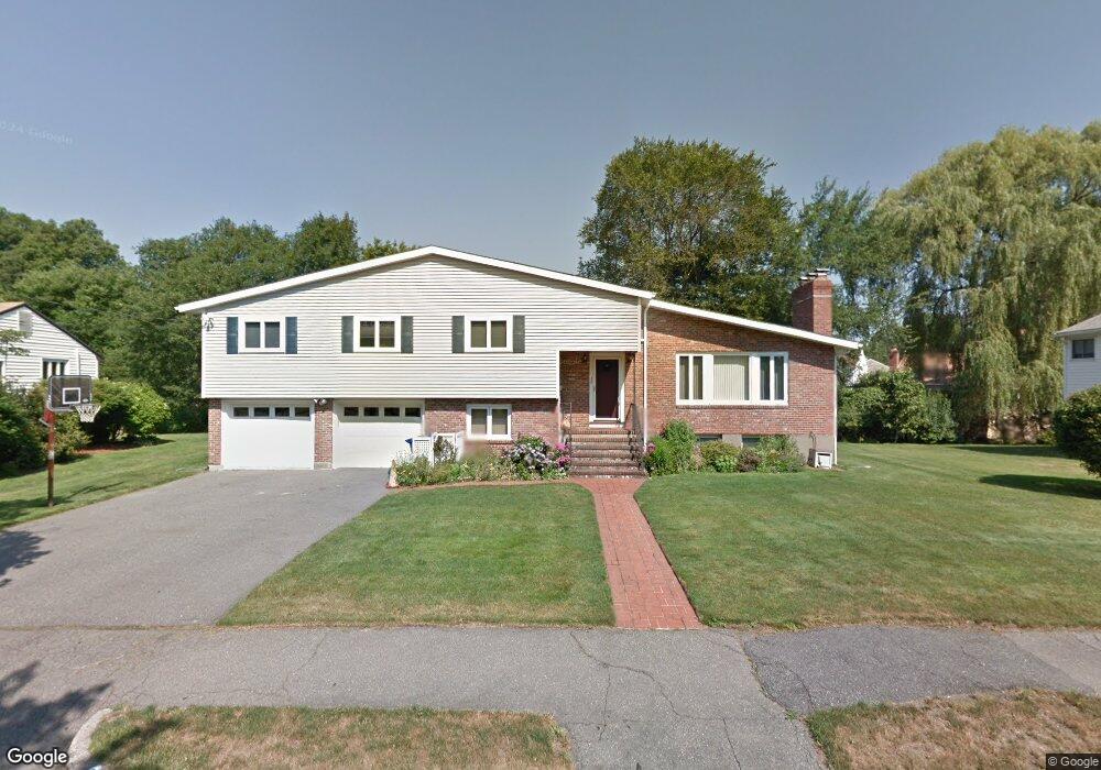
36 Brandeis Rd Newton Center, MA 02459
Oak Hill NeighborhoodEstimated Value: $1,494,000 - $1,801,000
5
Beds
3
Baths
2,017
Sq Ft
$823/Sq Ft
Est. Value
About This Home
This home is located at 36 Brandeis Rd, Newton Center, MA 02459 and is currently estimated at $1,659,841, approximately $822 per square foot. 36 Brandeis Rd is a home located in Middlesex County with nearby schools including Countryside Elementary School, Bowen School, and Charles E Brown Middle School.
Ownership History
Date
Name
Owned For
Owner Type
Purchase Details
Closed on
Sep 2, 1998
Sold by
Lyubashevsky Evgeny and Lyubashevsky Natalia
Bought by
Joe Douglas L and Joe Sue L
Current Estimated Value
Home Financials for this Owner
Home Financials are based on the most recent Mortgage that was taken out on this home.
Original Mortgage
$397,600
Outstanding Balance
$84,933
Interest Rate
6.9%
Mortgage Type
Purchase Money Mortgage
Estimated Equity
$1,574,908
Purchase Details
Closed on
Jun 25, 1992
Sold by
Sandler Eleanor R
Bought by
Mun Edward and Mun Seunghee L
Home Financials for this Owner
Home Financials are based on the most recent Mortgage that was taken out on this home.
Original Mortgage
$200,000
Interest Rate
8.57%
Mortgage Type
Purchase Money Mortgage
Create a Home Valuation Report for This Property
The Home Valuation Report is an in-depth analysis detailing your home's value as well as a comparison with similar homes in the area
Home Values in the Area
Average Home Value in this Area
Purchase History
| Date | Buyer | Sale Price | Title Company |
|---|---|---|---|
| Joe Douglas L | $497,000 | -- | |
| Mun Edward | $360,000 | -- |
Source: Public Records
Mortgage History
| Date | Status | Borrower | Loan Amount |
|---|---|---|---|
| Open | Joe Douglas L | $150,000 | |
| Open | Joe Douglas L | $397,600 | |
| Previous Owner | Joe Douglas L | $260,000 | |
| Previous Owner | Mun Edward | $200,000 |
Source: Public Records
Tax History Compared to Growth
Tax History
| Year | Tax Paid | Tax Assessment Tax Assessment Total Assessment is a certain percentage of the fair market value that is determined by local assessors to be the total taxable value of land and additions on the property. | Land | Improvement |
|---|---|---|---|---|
| 2025 | $13,944 | $1,422,900 | $1,034,000 | $388,900 |
| 2024 | $13,483 | $1,381,500 | $1,003,900 | $377,600 |
| 2023 | $12,840 | $1,261,300 | $781,400 | $479,900 |
| 2022 | $12,286 | $1,167,900 | $723,500 | $444,400 |
| 2021 | $11,855 | $1,101,800 | $682,500 | $419,300 |
| 2020 | $11,503 | $1,101,800 | $682,500 | $419,300 |
| 2019 | $11,178 | $1,069,700 | $662,600 | $407,100 |
| 2018 | $10,632 | $982,600 | $596,400 | $386,200 |
| 2017 | $10,308 | $927,000 | $562,600 | $364,400 |
| 2016 | $9,860 | $866,400 | $525,800 | $340,600 |
| 2015 | $9,401 | $809,700 | $491,400 | $318,300 |
Source: Public Records
Map
Nearby Homes
- 28 Brandeis Rd
- 44 Brandeis Rd
- 53 Roosevelt Rd
- 37 Roosevelt Rd
- 25 Brandeis Rd
- 25 Brandeis Rd Unit 4
- 67 Roosevelt Rd
- 20 Brandeis Rd
- 31 Roosevelt Rd
- 9 Jules Terrace
- 56 Roosevelt Rd
- 17 Jules Terrace
- 40 Roosevelt Rd
- 53 Brandeis Rd
- 25 Roosevelt Rd
- 66 Roosevelt Rd
- 17 Brandeis Rd
- 57 Theodore Rd
- 62 Theodore Rd
- 34 Roosevelt Rd