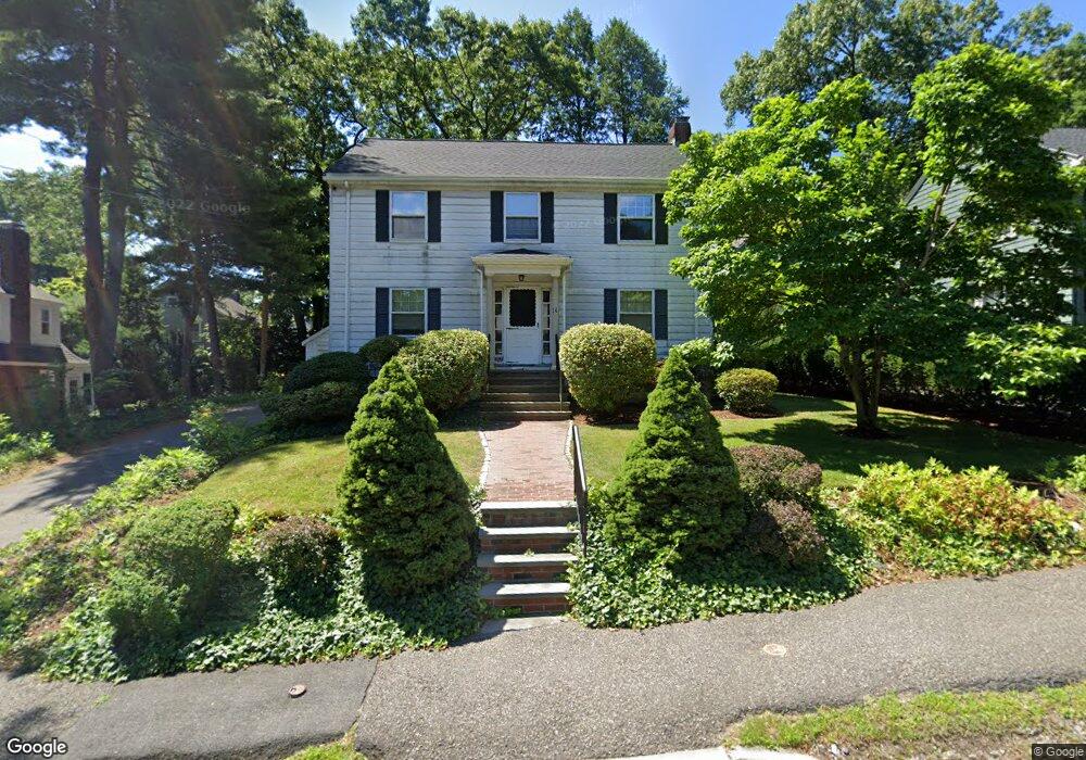
36 Calvin Rd Newtonville, MA 02460
Newtonville NeighborhoodEstimated Value: $1,416,000 - $1,565,000
4
Beds
2
Baths
1,936
Sq Ft
$762/Sq Ft
Est. Value
About This Home
This home is located at 36 Calvin Rd, Newtonville, MA 02460 and is currently estimated at $1,474,501, approximately $761 per square foot. 36 Calvin Rd is a home located in Middlesex County with nearby schools including Cabot Elementary School, F.A. Day Middle School, and Newton North High School.
Ownership History
Date
Name
Owned For
Owner Type
Purchase Details
Closed on
Apr 13, 1992
Sold by
Hayden Judith B
Bought by
Cohen Scott T and Cohen Joyce S
Current Estimated Value
Home Financials for this Owner
Home Financials are based on the most recent Mortgage that was taken out on this home.
Original Mortgage
$202,300
Interest Rate
8.73%
Mortgage Type
Purchase Money Mortgage
Purchase Details
Closed on
Aug 15, 1988
Sold by
Johnson Steven H
Bought by
Hayden Judith B
Home Financials for this Owner
Home Financials are based on the most recent Mortgage that was taken out on this home.
Original Mortgage
$250,000
Interest Rate
10.34%
Mortgage Type
Purchase Money Mortgage
Create a Home Valuation Report for This Property
The Home Valuation Report is an in-depth analysis detailing your home's value as well as a comparison with similar homes in the area
Home Values in the Area
Average Home Value in this Area
Purchase History
| Date | Buyer | Sale Price | Title Company |
|---|---|---|---|
| Cohen Scott T | $297,000 | -- | |
| Hayden Judith B | $331,000 | -- |
Source: Public Records
Mortgage History
| Date | Status | Borrower | Loan Amount |
|---|---|---|---|
| Closed | Hayden Judith B | $202,000 | |
| Closed | Hayden Judith B | $202,300 | |
| Previous Owner | Hayden Judith B | $250,000 |
Source: Public Records
Tax History Compared to Growth
Tax History
| Year | Tax Paid | Tax Assessment Tax Assessment Total Assessment is a certain percentage of the fair market value that is determined by local assessors to be the total taxable value of land and additions on the property. | Land | Improvement |
|---|---|---|---|---|
| 2025 | $11,910 | $1,215,300 | $1,047,100 | $168,200 |
| 2024 | $11,516 | $1,179,900 | $1,016,600 | $163,300 |
| 2023 | $10,873 | $1,068,100 | $780,000 | $288,100 |
| 2022 | $10,404 | $989,000 | $722,200 | $266,800 |
| 2021 | $10,039 | $933,000 | $681,300 | $251,700 |
| 2020 | $9,741 | $933,000 | $681,300 | $251,700 |
| 2019 | $9,466 | $905,800 | $661,500 | $244,300 |
| 2018 | $8,701 | $804,200 | $598,100 | $206,100 |
| 2017 | $8,437 | $758,700 | $564,200 | $194,500 |
| 2016 | $8,070 | $709,100 | $527,300 | $181,800 |
| 2015 | $7,694 | $662,700 | $492,800 | $169,900 |
Source: Public Records
Map
Nearby Homes
- 123-125 Mount Vernon St
- 123 Mount Vernon St Unit 2
- 22 Walnut Place Unit 1
- 957 Washington St Unit 1
- 935 Washington St Unit 8
- 911 Washington St
- 12 Wiswall St
- 4 Wiswall St
- 318 Austin St Unit A
- 27 Cross St Unit 27
- 43 Walker St
- 61 Lakeview Ave
- 300 Cabot St
- 11 Randlett Park
- 39 Valentine Park
- 10 Washington Park
- 10 Washington Park Unit 2
- 10 Washington Park Unit 1
- 32-34 Rossmere St
- 168 Walnut St