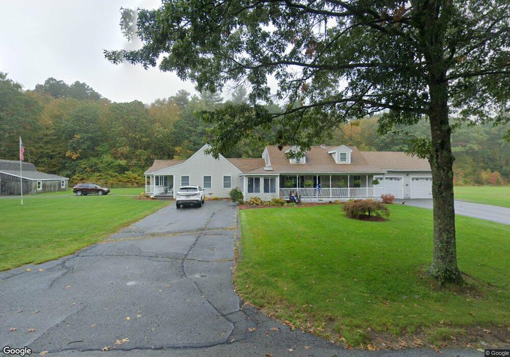
36 Esty Rd Princeton, MA 01541
Estimated Value: $577,000 - $845,000
4
Beds
2
Baths
2,812
Sq Ft
$245/Sq Ft
Est. Value
About This Home
This home is located at 36 Esty Rd, Princeton, MA 01541 and is currently estimated at $688,985, approximately $245 per square foot. 36 Esty Rd is a home located in Worcester County with nearby schools including Wachusett Regional High School.
Ownership History
Date
Name
Owned For
Owner Type
Purchase Details
Closed on
Apr 1, 2022
Sold by
Chiavaras Kristen
Bought by
Chiavaras Kristen and Chiavaras Thomas
Current Estimated Value
Home Financials for this Owner
Home Financials are based on the most recent Mortgage that was taken out on this home.
Original Mortgage
$390,000
Outstanding Balance
$363,606
Interest Rate
3.89%
Mortgage Type
New Conventional
Estimated Equity
$325,379
Purchase Details
Closed on
Aug 2, 2012
Sold by
Chiavaras Thomas
Bought by
Chiavaras Kristen
Purchase Details
Closed on
Jun 5, 2012
Sold by
Gates Barbara L
Bought by
Chiavaras Kristen and Chiavaras Thomas
Create a Home Valuation Report for This Property
The Home Valuation Report is an in-depth analysis detailing your home's value as well as a comparison with similar homes in the area
Home Values in the Area
Average Home Value in this Area
Purchase History
| Date | Buyer | Sale Price | Title Company |
|---|---|---|---|
| Chiavaras Kristen | -- | None Available | |
| Chiavaras Kristen | -- | None Available | |
| Chiavaras Kristen | -- | -- | |
| Chiavaras Kristen | -- | -- | |
| Chiavaras Kristen | -- | -- | |
| Chiavaras Kristen | -- | -- |
Source: Public Records
Mortgage History
| Date | Status | Borrower | Loan Amount |
|---|---|---|---|
| Open | Chiavaras Kristen | $390,000 | |
| Closed | Chiavaras Kristen | $390,000 | |
| Previous Owner | Chiavaras Kristen | $50,000 | |
| Previous Owner | Chiavaras Kristen | $50,000 |
Source: Public Records
Tax History Compared to Growth
Tax History
| Year | Tax Paid | Tax Assessment Tax Assessment Total Assessment is a certain percentage of the fair market value that is determined by local assessors to be the total taxable value of land and additions on the property. | Land | Improvement |
|---|---|---|---|---|
| 2025 | $7,771 | $534,800 | $135,100 | $399,700 |
| 2024 | $7,207 | $513,700 | $135,100 | $378,600 |
| 2023 | $6,730 | $444,500 | $107,800 | $336,700 |
| 2022 | $6,421 | $409,500 | $107,800 | $301,700 |
| 2021 | $6,334 | $392,900 | $107,800 | $285,100 |
| 2020 | $6,132 | $386,900 | $107,800 | $279,100 |
| 2019 | $6,052 | $377,800 | $105,200 | $272,600 |
| 2018 | $6,072 | $351,400 | $96,500 | $254,900 |
| 2017 | $5,025 | $282,600 | $140,800 | $141,800 |
| 2016 | $5,030 | $282,600 | $140,800 | $141,800 |
| 2015 | $4,652 | $268,900 | $138,400 | $130,500 |
Source: Public Records
Map
Nearby Homes
- 20 Town Farm Rd
- 17 Coal Kiln Rd
- 100 Houghton Rd
- 751 Mason Rd
- 14 Oak Cir
- 28 Merriam Rd
- 11 Mirick Rd
- 45 Neylon St
- 20 Mountain Rd
- 9 Stagecoach Rd
- 58 Merriam Rd
- 15 Stagecoach Rd
- 0 North St
- 61 Boutelle Rd
- 19 Hardscrabble Rd
- 4 Jewett Rd Unit B
- 4 Jewett Rd Unit A
- 193 Justice Hill Road Cutoff
- 223 Worcester Rd
- 133 Rowley Hill Rd