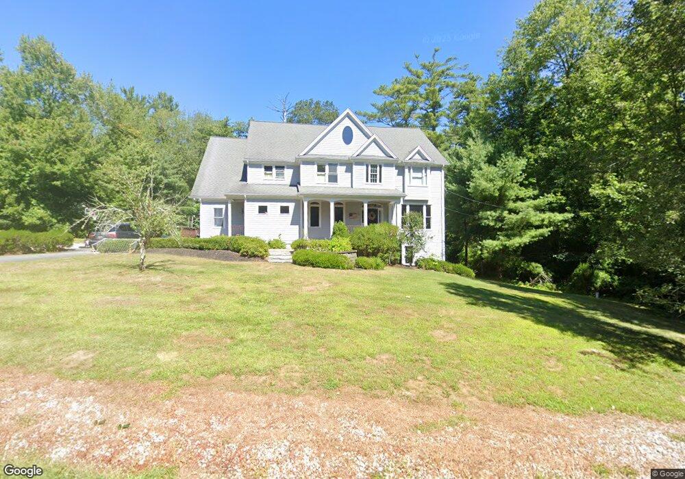
36 Green St Norwell, MA 02061
Estimated Value: $1,376,000 - $1,889,000
4
Beds
4
Baths
3,142
Sq Ft
$499/Sq Ft
Est. Value
About This Home
This home is located at 36 Green St, Norwell, MA 02061 and is currently estimated at $1,569,257, approximately $499 per square foot. 36 Green St is a home located in Plymouth County with nearby schools including Grace Farrar Cole Elementary School, Norwell Middle School, and Norwell High School.
Ownership History
Date
Name
Owned For
Owner Type
Purchase Details
Closed on
Sep 29, 2011
Sold by
Noyce Scott R and Noyce Kathryn L
Bought by
Griffin Timothy and Scofield Amy K
Current Estimated Value
Home Financials for this Owner
Home Financials are based on the most recent Mortgage that was taken out on this home.
Original Mortgage
$523,750
Outstanding Balance
$358,078
Interest Rate
4.15%
Mortgage Type
Purchase Money Mortgage
Estimated Equity
$1,211,179
Purchase Details
Closed on
Feb 3, 2004
Sold by
Shute Donald E
Bought by
Noyce Scott R and Noyce Kathryn L
Create a Home Valuation Report for This Property
The Home Valuation Report is an in-depth analysis detailing your home's value as well as a comparison with similar homes in the area
Home Values in the Area
Average Home Value in this Area
Purchase History
| Date | Buyer | Sale Price | Title Company |
|---|---|---|---|
| Griffin Timothy | $775,000 | -- | |
| Griffin Timothy | $775,000 | -- | |
| Noyce Scott R | $291,500 | -- | |
| Noyce Scott R | $291,500 | -- |
Source: Public Records
Mortgage History
| Date | Status | Borrower | Loan Amount |
|---|---|---|---|
| Open | Griffin Timothy | $523,750 | |
| Closed | Noyce Scott R | $76,250 | |
| Closed | Noyce Scott R | $523,750 |
Source: Public Records
Tax History Compared to Growth
Tax History
| Year | Tax Paid | Tax Assessment Tax Assessment Total Assessment is a certain percentage of the fair market value that is determined by local assessors to be the total taxable value of land and additions on the property. | Land | Improvement |
|---|---|---|---|---|
| 2025 | $15,285 | $1,169,500 | $395,800 | $773,700 |
| 2024 | $14,266 | $1,059,900 | $373,500 | $686,400 |
| 2023 | $14,186 | $927,800 | $287,200 | $640,600 |
| 2022 | $13,539 | $814,600 | $249,700 | $564,900 |
| 2021 | $59 | $757,400 | $262,800 | $494,600 |
| 2020 | $60 | $743,500 | $262,800 | $480,700 |
| 2019 | $7 | $712,600 | $262,800 | $449,800 |
| 2018 | $8,420 | $707,700 | $262,800 | $444,900 |
| 2017 | $7,978 | $707,700 | $262,800 | $444,900 |
| 2016 | $11,326 | $686,400 | $262,800 | $423,600 |
| 2015 | $11,015 | $667,600 | $262,800 | $404,800 |
| 2014 | $10,456 | $638,700 | $266,300 | $372,400 |
Source: Public Records
Map
Nearby Homes
- 260 River St
- 250 River St
- 37 Tara Dr
- 198 Pine St
- 28 Riverside Dr
- 2 Curtis Farm Rd
- 10 Shrine Rd
- 72 Chittenden Ln
- 0 Island View Cir
- 685 Highland St
- 451 Main St
- 908 Main St
- 20 Meadow Brook Rd
- 182 Oak St
- 34 Canonchet Trail
- 479 Clapp Brook Rd
- 133 Brigantine Cir
- 11 Silver Brook Ln Unit 11
- 91 Metacomet Way
- 28 Old Shipyard Ln