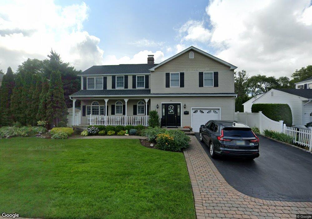
36 Magnolia St Westbury, NY 11590
Estimated Value: $1,057,429 - $1,142,000
--
Bed
3
Baths
2,685
Sq Ft
$410/Sq Ft
Est. Value
About This Home
This home is located at 36 Magnolia St, Westbury, NY 11590 and is currently estimated at $1,099,715, approximately $409 per square foot. 36 Magnolia St is a home located in Nassau County with nearby schools including Cherry Lane School, Rushmore Avenue School, and Carle Place High School.
Ownership History
Date
Name
Owned For
Owner Type
Purchase Details
Closed on
Jul 19, 2024
Sold by
Tirone Linda and Tirone Philip
Bought by
Selhorn Jennifer and Tirone Scott
Current Estimated Value
Purchase Details
Closed on
Sep 11, 2023
Sold by
Tirone Linda
Bought by
Tirone Linda and Tirone Philip
Purchase Details
Closed on
Oct 11, 2005
Sold by
Tirone Philip
Create a Home Valuation Report for This Property
The Home Valuation Report is an in-depth analysis detailing your home's value as well as a comparison with similar homes in the area
Home Values in the Area
Average Home Value in this Area
Purchase History
| Date | Buyer | Sale Price | Title Company |
|---|---|---|---|
| Selhorn Jennifer | -- | East Coast Abstract Inc | |
| Selhorn Jennifer | -- | East Coast Abstract Inc | |
| Tirone Linda | -- | East Coast Abstract Inc | |
| Tirone Linda | -- | East Coast Abstract Inc | |
| Tirone Linda | -- | East Coast Abstract Inc | |
| -- | -- | -- | |
| -- | -- | -- |
Source: Public Records
Tax History Compared to Growth
Tax History
| Year | Tax Paid | Tax Assessment Tax Assessment Total Assessment is a certain percentage of the fair market value that is determined by local assessors to be the total taxable value of land and additions on the property. | Land | Improvement |
|---|---|---|---|---|
| 2025 | $17,278 | $736 | $305 | $431 |
| 2024 | $4,276 | $736 | $305 | $431 |
| 2023 | $15,116 | $780 | $330 | $450 |
| 2022 | $15,116 | $736 | $305 | $431 |
| 2021 | $12,563 | $764 | $317 | $447 |
| 2020 | $11,909 | $721 | $527 | $194 |
| 2019 | $10,145 | $772 | $528 | $244 |
| 2018 | $10,224 | $824 | $0 | $0 |
| 2017 | $7,511 | $875 | $532 | $343 |
| 2016 | $10,153 | $927 | $508 | $419 |
| 2015 | $2,892 | $978 | $536 | $442 |
| 2014 | $2,892 | $978 | $536 | $442 |
| 2013 | $2,895 | $1,030 | $564 | $466 |
Source: Public Records
Map
Nearby Homes
- 45 Manchester St
- 330 Ellison Ave
- 85 Aspinwall St
- 24 Walnut St
- 333 Sylvan Ln
- 355 Sylvan Ln
- 51 Wickey Ave
- 68 Oriole Way
- 172 Harvard St
- 64 Wilson Ave
- 154 Elmwood St
- 175 Maple Ave Unit 5G
- 83 Renison Dr
- 198 Belmont Ave
- 187 Castle Ave
- 119 Broadmoor Ln
- 205 Schenck Ave
- 132 Gordon Ave
- 213 Belmont Ave
- 242 Maple Ave Unit 513