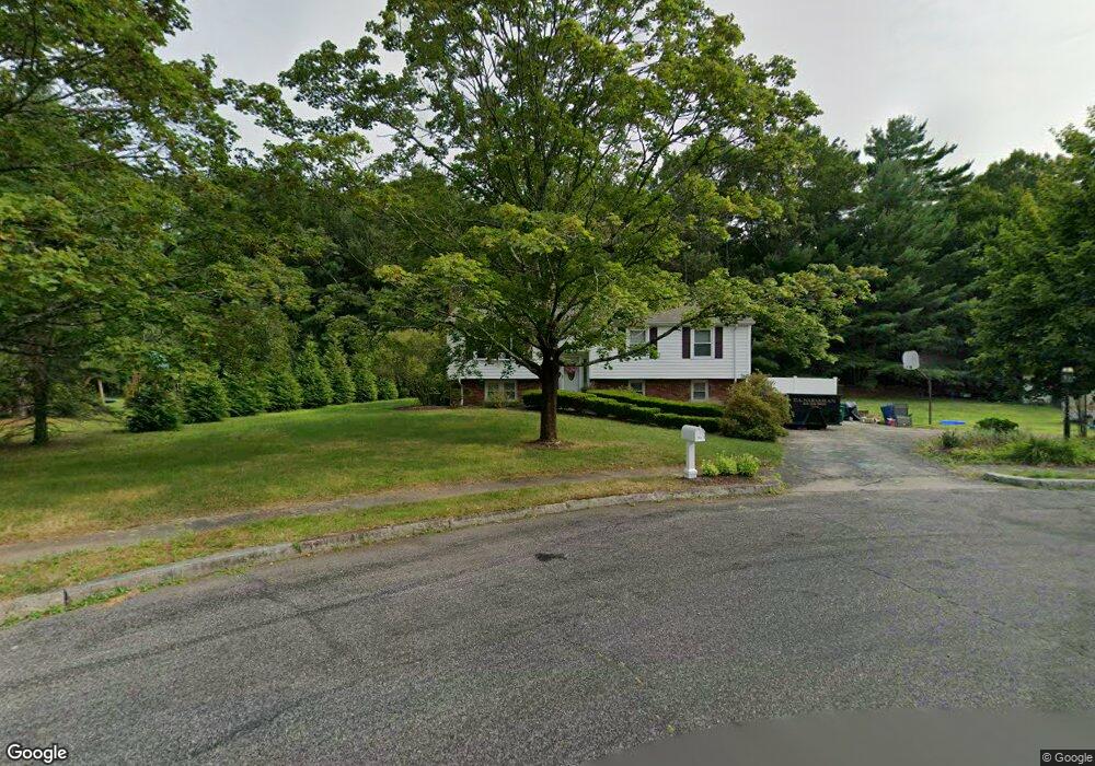
36 Maverick Dr Mansfield, MA 02048
Estimated Value: $589,000 - $755,000
3
Beds
2
Baths
1,509
Sq Ft
$455/Sq Ft
Est. Value
About This Home
This home is located at 36 Maverick Dr, Mansfield, MA 02048 and is currently estimated at $687,275, approximately $455 per square foot. 36 Maverick Dr is a home located in Bristol County with nearby schools including Everett W. Robinson Elementary School, Jordan/Jackson Elementary School, and Harold L. Qualters Middle School.
Ownership History
Date
Name
Owned For
Owner Type
Purchase Details
Closed on
Feb 10, 2006
Sold by
Calusdian Barbara J and Calusdian David C
Bought by
Hobbs Heidi L and Hobbs Richard C
Current Estimated Value
Home Financials for this Owner
Home Financials are based on the most recent Mortgage that was taken out on this home.
Original Mortgage
$173,000
Interest Rate
6.27%
Mortgage Type
Purchase Money Mortgage
Purchase Details
Closed on
Jul 30, 1998
Sold by
Alksninis Michael F and Alksninis Barbara L
Bought by
Calusdian David C and Calusdian Barbara J
Create a Home Valuation Report for This Property
The Home Valuation Report is an in-depth analysis detailing your home's value as well as a comparison with similar homes in the area
Home Values in the Area
Average Home Value in this Area
Purchase History
| Date | Buyer | Sale Price | Title Company |
|---|---|---|---|
| Hobbs Heidi L | $373,000 | -- | |
| Calusdian David C | $192,000 | -- |
Source: Public Records
Mortgage History
| Date | Status | Borrower | Loan Amount |
|---|---|---|---|
| Open | Calusdian David C | $216,700 | |
| Closed | Hobbs Heidi L | $173,000 |
Source: Public Records
Tax History Compared to Growth
Tax History
| Year | Tax Paid | Tax Assessment Tax Assessment Total Assessment is a certain percentage of the fair market value that is determined by local assessors to be the total taxable value of land and additions on the property. | Land | Improvement |
|---|---|---|---|---|
| 2025 | $8,001 | $607,500 | $289,900 | $317,600 |
| 2024 | $7,494 | $555,100 | $277,200 | $277,900 |
| 2023 | $7,327 | $520,000 | $277,200 | $242,800 |
| 2022 | $7,115 | $469,000 | $257,500 | $211,500 |
| 2021 | $6,950 | $452,500 | $243,700 | $208,800 |
| 2020 | $6,583 | $428,600 | $214,400 | $214,200 |
| 2019 | $6,373 | $418,700 | $204,500 | $214,200 |
| 2018 | $6,128 | $393,600 | $195,600 | $198,000 |
| 2017 | $5,888 | $392,000 | $190,400 | $201,600 |
| 2016 | $5,643 | $366,200 | $181,500 | $184,700 |
| 2015 | $5,281 | $340,700 | $181,500 | $159,200 |
Source: Public Records
Map
Nearby Homes
- 24 Maverick Dr
- 150 Gilbert St
- 116 George St
- 4 Buckskin Dr
- 11 Landry Ave
- 196 Donald Tennant Cir
- 16 Treasure Island Rd
- 5 Old Wood Rd
- 406 South St
- 15 Old Wood Rd
- 255 Mckeon Dr
- 28 Messenger St
- 57 Vine St
- 115 Westfield Dr
- 9 Oak Dr
- 9 Sunnyside Dr Unit 9
- Lot 5 Jeffrey Dr
- 11 Buckthorn Ln
- Lot 2 Jeffrey Dr
- 126 Washington St