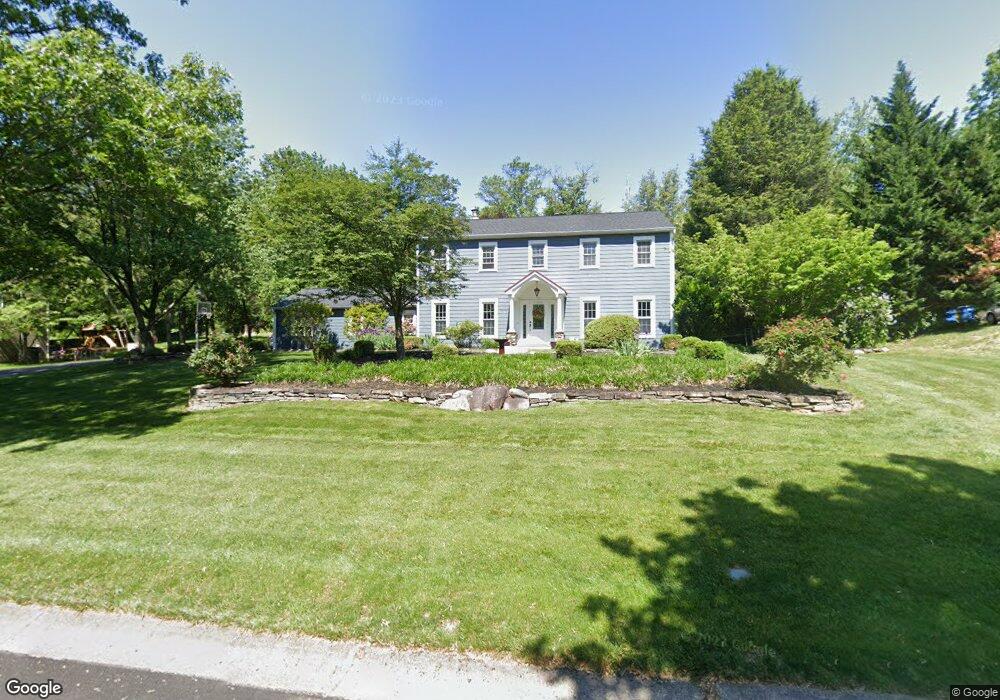
36 Pheasant Rd Doylestown, PA 18901
Estimated Value: $787,000 - $946,000
4
Beds
3
Baths
3,350
Sq Ft
$260/Sq Ft
Est. Value
About This Home
This home is located at 36 Pheasant Rd, Doylestown, PA 18901 and is currently estimated at $870,248, approximately $259 per square foot. 36 Pheasant Rd is a home located in Bucks County with nearby schools including Kutz Elementary School, Lenape Middle School, and Central Bucks High School-West.
Ownership History
Date
Name
Owned For
Owner Type
Purchase Details
Closed on
Oct 20, 2011
Sold by
Johnson Todd T and Johnson Laura K
Bought by
Johnson Todd T and Johnson Laura K
Current Estimated Value
Home Financials for this Owner
Home Financials are based on the most recent Mortgage that was taken out on this home.
Original Mortgage
$298,400
Outstanding Balance
$117,535
Interest Rate
4.08%
Mortgage Type
New Conventional
Estimated Equity
$752,713
Purchase Details
Closed on
Feb 15, 1999
Sold by
Smith David A and Mckernan Matthew
Bought by
Brennan Ryan R and Brennan Mary Beth
Home Financials for this Owner
Home Financials are based on the most recent Mortgage that was taken out on this home.
Original Mortgage
$150,000
Interest Rate
6.83%
Create a Home Valuation Report for This Property
The Home Valuation Report is an in-depth analysis detailing your home's value as well as a comparison with similar homes in the area
Home Values in the Area
Average Home Value in this Area
Purchase History
We collect this data history from publicly available records. To have your information removed, we recommend requesting removal directly through your county’s website.
| Date | Buyer | Sale Price | Title Company |
|---|---|---|---|
| Johnson Todd T | -- | None Available | |
| Brennan Ryan R | $200,000 | -- |
Source: Public Records
Mortgage History
We collect this data history from publicly available records. To have your information removed, we recommend requesting removal directly through your county’s website.
| Date | Status | Borrower | Loan Amount |
|---|---|---|---|
| Open | Johnson Todd T | $298,400 | |
| Previous Owner | Brennan Ryan R | $150,000 | |
| Closed | Brennan Ryan R | $30,000 |
Source: Public Records
Tax History
| Year | Tax Paid | Tax Assessment Tax Assessment Total Assessment is a certain percentage of the fair market value that is determined by local assessors to be the total taxable value of land and additions on the property. | Land | Improvement |
|---|---|---|---|---|
| 2025 | $7,719 | $43,620 | $8,600 | $35,020 |
| 2024 | $7,719 | $43,620 | $8,600 | $35,020 |
| 2023 | $7,360 | $43,620 | $8,600 | $35,020 |
| 2022 | $7,278 | $43,620 | $8,600 | $35,020 |
| 2021 | $6,406 | $39,200 | $8,600 | $30,600 |
| 2020 | $6,377 | $39,200 | $8,600 | $30,600 |
| 2019 | $6,308 | $39,200 | $8,600 | $30,600 |
| 2018 | $6,289 | $39,200 | $8,600 | $30,600 |
| 2017 | $6,240 | $39,200 | $8,600 | $30,600 |
| 2016 | $6,200 | $39,200 | $8,600 | $30,600 |
| 2015 | -- | $39,200 | $8,600 | $30,600 |
| 2014 | -- | $39,200 | $8,600 | $30,600 |
Source: Public Records
Map
Nearby Homes
- 19 Eljan Dr
- 1 Cedar Ln
- 000 Cherry Ln
- 3795 Route 202
- 3775 Buckingham Dr
- 95 Springs Dr
- 15 Dogwood Ln
- 150 Watercrest Dr
- 465 E State St
- 223 Cherry Ln
- 152 Watercrest Dr
- 113 Watercrest Dr
- 612 S Chubb Dr
- 563 Pebble Hill Rd
- 7 Mercer Gate Dr
- 94 East St
- 528 E Court St
- 4009 Smoke Rd
- 110 E Ashland St
- 92 Homestead Dr
Your Personal Tour Guide
Ask me questions while you tour the home.