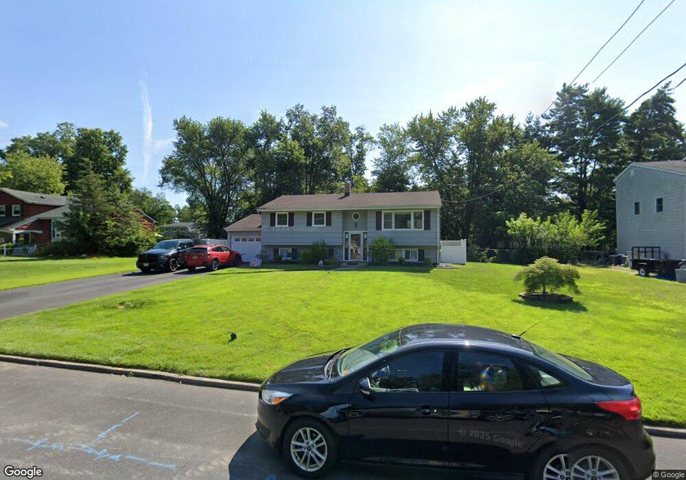
36 Shady Ln Bound Brook, NJ 08805
Estimated Value: $507,000 - $648,000
--
Bed
--
Bath
2,300
Sq Ft
$257/Sq Ft
Est. Value
About This Home
This home is located at 36 Shady Ln, Bound Brook, NJ 08805 and is currently estimated at $591,578, approximately $257 per square foot. 36 Shady Ln is a home located in Somerset County with nearby schools including Adamsville Primary School, Bridgewater-Raritan Middle School, and Hillside Intermediate School.
Ownership History
Date
Name
Owned For
Owner Type
Purchase Details
Closed on
Mar 20, 2017
Sold by
Heuner Robert C and Heuner Mary Ann
Bought by
Heuner Robert and Heuner Christine C
Current Estimated Value
Home Financials for this Owner
Home Financials are based on the most recent Mortgage that was taken out on this home.
Original Mortgage
$250,000
Outstanding Balance
$207,198
Interest Rate
4.15%
Mortgage Type
New Conventional
Estimated Equity
$384,380
Create a Home Valuation Report for This Property
The Home Valuation Report is an in-depth analysis detailing your home's value as well as a comparison with similar homes in the area
Home Values in the Area
Average Home Value in this Area
Purchase History
| Date | Buyer | Sale Price | Title Company |
|---|---|---|---|
| Heuner Robert | $312,500 | None Available |
Source: Public Records
Mortgage History
| Date | Status | Borrower | Loan Amount |
|---|---|---|---|
| Open | Heuner Robert | $250,000 |
Source: Public Records
Tax History Compared to Growth
Tax History
| Year | Tax Paid | Tax Assessment Tax Assessment Total Assessment is a certain percentage of the fair market value that is determined by local assessors to be the total taxable value of land and additions on the property. | Land | Improvement |
|---|---|---|---|---|
| 2025 | $7,450 | $381,700 | $222,200 | $159,500 |
| 2024 | $7,450 | $378,000 | $222,200 | $155,800 |
| 2023 | $7,157 | $356,600 | $222,200 | $134,400 |
| 2022 | $6,948 | $333,100 | $217,200 | $115,900 |
| 2021 | $6,961 | $326,500 | $217,200 | $109,300 |
| 2020 | $6,916 | $325,000 | $217,200 | $107,800 |
| 2019 | $6,823 | $317,500 | $217,200 | $100,300 |
| 2018 | $6,683 | $311,700 | $217,200 | $94,500 |
| 2017 | $6,541 | $304,800 | $217,200 | $87,600 |
| 2016 | $7,104 | $335,900 | $217,200 | $118,700 |
| 2015 | $7,108 | $336,400 | $217,200 | $119,200 |
| 2014 | $7,057 | $329,000 | $217,200 | $111,800 |
Source: Public Records
Map
Nearby Homes
- 143 Vosseller Ave
- 563 Winsor St
- 606 Vosseller Ave
- 745 Schoolhouse Ln
- 617 Vosseller Ave
- 1740 Middlebrook Rd
- 180 Farm Ln
- 650 Central Ave
- 520 Winsor St
- 307 W Union Ave
- 601 Thompson Ave
- 14 E Maple Ave
- 597 Mountain Ave
- 581 Mountain Ave
- 102 W Franklin St
- 641 Crescent Dr
- 320 Church St
- 1820 Woodland Terrace
- 130 W High St Unit 132
- 126 W High St