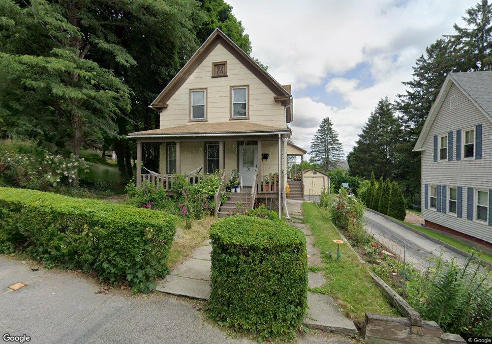
36 Tatman St Worcester, MA 01607
North Quinsigamond Village NeighborhoodEstimated Value: $392,972 - $455,000
3
Beds
2
Baths
1,539
Sq Ft
$272/Sq Ft
Est. Value
About This Home
This home is located at 36 Tatman St, Worcester, MA 01607 and is currently estimated at $418,743, approximately $272 per square foot. 36 Tatman St is a home located in Worcester County with nearby schools including Quinsigamond School, Jacob Hiatt Magnet School, and Chandler Magnet.
Ownership History
Date
Name
Owned For
Owner Type
Purchase Details
Closed on
Jan 23, 2001
Sold by
Raghavendra Amrigha R and Sudeheendra Anuradha
Bought by
Sudheendra Anuradha and Sudheendra Kudrethaya
Current Estimated Value
Home Financials for this Owner
Home Financials are based on the most recent Mortgage that was taken out on this home.
Original Mortgage
$112,500
Interest Rate
7.52%
Mortgage Type
Purchase Money Mortgage
Purchase Details
Closed on
Dec 4, 1997
Sold by
Gormley Patrick G and Gormley Margaaret J
Bought by
Raghavendra Amritha and Sudheendra Anuradha
Purchase Details
Closed on
Aug 28, 1987
Sold by
Beaudry Rudy L
Bought by
Gormley Margaret
Create a Home Valuation Report for This Property
The Home Valuation Report is an in-depth analysis detailing your home's value as well as a comparison with similar homes in the area
Home Values in the Area
Average Home Value in this Area
Purchase History
| Date | Buyer | Sale Price | Title Company |
|---|---|---|---|
| Sudheendra Anuradha | $20,000 | -- | |
| Raghavendra Amritha | $70,100 | -- | |
| Gormley Margaret | $98,000 | -- |
Source: Public Records
Mortgage History
| Date | Status | Borrower | Loan Amount |
|---|---|---|---|
| Open | Gormley Margaret | $144,000 | |
| Closed | Gormley Margaret | $123,200 | |
| Closed | Gormley Margaret | $112,500 |
Source: Public Records
Tax History
| Year | Tax Paid | Tax Assessment Tax Assessment Total Assessment is a certain percentage of the fair market value that is determined by local assessors to be the total taxable value of land and additions on the property. | Land | Improvement |
|---|---|---|---|---|
| 2025 | $4,382 | $332,200 | $118,300 | $213,900 |
| 2024 | $4,228 | $307,500 | $118,300 | $189,200 |
| 2023 | $4,042 | $281,900 | $102,800 | $179,100 |
| 2022 | $3,702 | $243,400 | $82,300 | $161,100 |
| 2021 | $3,585 | $220,200 | $65,800 | $154,400 |
| 2020 | $3,436 | $202,100 | $65,800 | $136,300 |
| 2019 | $3,303 | $183,500 | $59,300 | $124,200 |
| 2018 | $3,304 | $174,700 | $59,300 | $115,400 |
| 2017 | $3,179 | $165,400 | $59,300 | $106,100 |
| 2016 | $3,100 | $150,400 | $43,300 | $107,100 |
| 2015 | $3,019 | $150,400 | $43,300 | $107,100 |
| 2014 | $2,939 | $150,400 | $43,300 | $107,100 |
Source: Public Records
Map
Nearby Homes
Your Personal Tour Guide
Ask me questions while you tour the home.