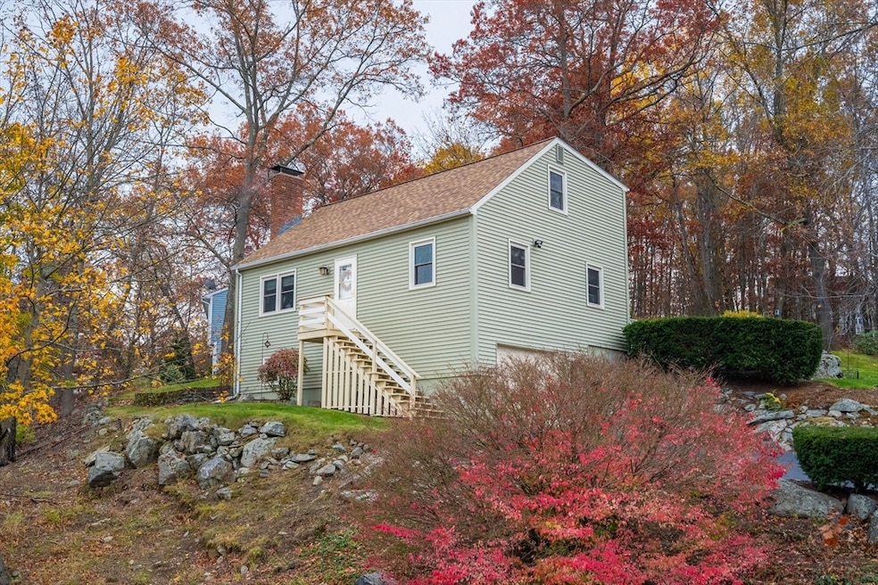
36 Westborough St Worcester, MA 01604
Broadmeadow Brook NeighborhoodEstimated payment $2,788/month
Highlights
- Medical Services
- Cape Cod Architecture
- Property is near public transit
- City View
- Wood Burning Stove
- Wood Flooring
About This Home
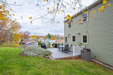
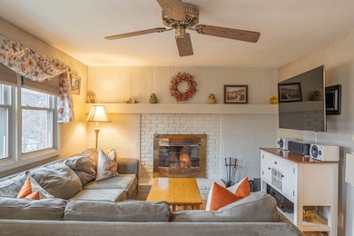
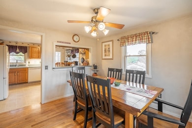
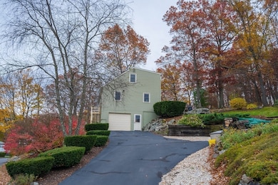
This well maintained three bedroom, two bath home in Worcester is listed well below market price & minutes to Mass Pike, I-290 and area amenities. Many upgrades including newer roof, maintenance free vinyl siding and energy star windows, ensuring years of low cost living. The home features an inviting fireplace in the living room, a good sized dining room, a functional kitchen and a bonus family room and office space in the finished basement. Plus a good sized laundry/utility room. The home also has a one car garage with automatic door opener. A nicely maintained yard features a new timber tech style deck, numerous seating areas to enjoy the tranquility and awesome views of sunsets. The homeowners understand that the driveway can be a challenge but with a few helpful tips, the concerns can be greatly reduced. And there are a number of benefits to living off of the street, including less street noise and more privacy. Schedule a showing to see all that this home has to offer!
Home Details
Home Type
- Single Family
Est. Annual Taxes
- $5,011
Year Built
- Built in 1986
Lot Details
- 0.42 Acre Lot
- Sloped Lot
- Cleared Lot
- Property is zoned RS-7
Parking
- 1 Car Attached Garage
- Tuck Under Parking
- Driveway
- Open Parking
- Off-Street Parking
Property Views
- City
- Scenic Vista
Home Design
- Cape Cod Architecture
- Frame Construction
- Shingle Roof
- Concrete Perimeter Foundation
Interior Spaces
- 1,344 Sq Ft Home
- Ceiling Fan
- Recessed Lighting
- Wood Burning Stove
- Window Screens
- Living Room with Fireplace
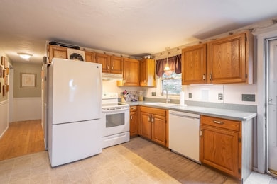
Kitchen
- Breakfast Bar
- Range
- Dishwasher
- Solid Surface Countertops
Flooring
- Wood
- Wall to Wall Carpet
- Vinyl
Bedrooms and Bathrooms
- 3 Bedrooms
- Primary bedroom located on second floor
- 2 Full Bathrooms
- Bathtub with Shower
- Separate Shower
Laundry
- Laundry Room
- Washer and Electric Dryer Hookup
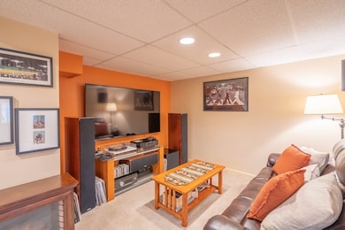
Finished Basement
- Walk-Out Basement
- Basement Fills Entire Space Under The House
- Interior Basement Entry
- Garage Access
- Laundry in Basement
Outdoor Features
- Patio
- Rain Gutters
Location
- Property is near public transit
- Property is near schools
Utilities
- Window Unit Cooling System
- 2 Heating Zones
- Heating System Uses Oil
- Baseboard Heating
- Tankless Water Heater
- High Speed Internet
- Internet Available
- Cable TV Available
Listing and Financial Details
- Assessor Parcel Number M:41 B:035 L:00005,1798941
Community Details
Overview
- No Home Owners Association
Amenities
- Medical Services
- Shops
Recreation
- Park
- Jogging Path
Map
Home Values in the Area
Average Home Value in this Area
Tax History
| Year | Tax Paid | Tax Assessment Tax Assessment Total Assessment is a certain percentage of the fair market value that is determined by local assessors to be the total taxable value of land and additions on the property. | Land | Improvement |
|---|---|---|---|---|
| 2025 | $5,011 | $379,900 | $119,300 | $260,600 |
| 2024 | $4,912 | $357,200 | $119,300 | $237,900 |
| 2023 | $4,708 | $328,300 | $103,700 | $224,600 |
| 2022 | $4,314 | $283,600 | $82,900 | $200,700 |
| 2021 | $4,161 | $255,600 | $66,300 | $189,300 |
| 2020 | $4,055 | $238,500 | $66,300 | $172,200 |
| 2019 | $3,859 | $214,400 | $59,900 | $154,500 |
| 2018 | $3,871 | $204,700 | $59,900 | $144,800 |
| 2017 | $3,706 | $192,800 | $59,900 | $132,900 |
| 2016 | $3,671 | $178,100 | $45,200 | $132,900 |
| 2015 | $3,574 | $178,100 | $45,200 | $132,900 |
| 2014 | $3,480 | $178,100 | $45,200 | $132,900 |
Property History
| Date | Event | Price | List to Sale | Price per Sq Ft |
|---|---|---|---|---|
| 11/23/2025 11/23/25 | Price Changed | $450,000 | -4.2% | $335 / Sq Ft |
| 11/17/2025 11/17/25 | Price Changed | $469,900 | -2.1% | $350 / Sq Ft |
| 11/06/2025 11/06/25 | For Sale | $479,900 | -- | $357 / Sq Ft |
Purchase History
| Date | Type | Sale Price | Title Company |
|---|---|---|---|
| Deed | $139,000 | -- | |
| Deed | $127,500 | -- | |
| Deed | $105,000 | -- | |
| Deed | $89,900 | -- |
Mortgage History
| Date | Status | Loan Amount | Loan Type |
|---|---|---|---|
| Open | $184,000 | No Value Available | |
| Closed | $166,000 | No Value Available | |
| Closed | $142,000 | No Value Available |
Source: MLS Property Information Network (MLS PIN)
MLS Number: 73452298
APN: WORC-000041-000035-000005
Disclaimer: Certain information contained herein is derived from information provided by parties other than Homes.com. All information provided is deemed reliable, but is not guaranteed to be accurate and should be independently verified.
![]() The property listing data and information, or the Images, set forth herein were provided to MLS Property Information Network, Inc. from third party sources, including sellers, lessors and public records, and were compiled by MLS Property Information Network, Inc. The property listing data and information, and the Images, are for the personal, non-commercial use of consumers having a good faith interest in purchasing or leasing listed properties of the type displayed to them and may not be used for any purpose other than to identify prospective properties which such consumers may have a good faith interest in purchasing or leasing. MLS Property Information Network, Inc. and its subscribers disclaim any and all representations and warranties as to the accuracy of the property listing data and information, or as to the accuracy of any of the Images, set forth herein.
The property listing data and information, or the Images, set forth herein were provided to MLS Property Information Network, Inc. from third party sources, including sellers, lessors and public records, and were compiled by MLS Property Information Network, Inc. The property listing data and information, and the Images, are for the personal, non-commercial use of consumers having a good faith interest in purchasing or leasing listed properties of the type displayed to them and may not be used for any purpose other than to identify prospective properties which such consumers may have a good faith interest in purchasing or leasing. MLS Property Information Network, Inc. and its subscribers disclaim any and all representations and warranties as to the accuracy of the property listing data and information, or as to the accuracy of any of the Images, set forth herein.
- 38 Etre Dr
- 589 Sunderland Rd
- 39 Pointe Rok Dr Unit 39
- 48 Pointe Rok Dr Unit 48G
- 15 Lakeside Dr
- 33 Lakeside Dr
- 31 Crane St
- 62 Edgemere Blvd
- 7 Atlas St
- 1201 Grafton St Unit 73
- 27 A-B Grafton St
- 11 Maplewood Rd
- 23 Canna Dr
- 151 Hartford Turnpike Unit 13
- 232 Weatherstone Dr
- 340 Sunderland Rd Unit 23
- 270 Sunderland Rd Unit 37
- 1 Canton Ct Unit 35
- 330 Sunderland Rd Unit 78
- 330 Sunderland Rd Unit 87
- 4 Westborough St
- 48 Pointe Rok Dr Unit 48G
- 15 Burghardt St Unit B
- 10 Beverly Cove
- 3 Flagg Rd
- 1168 Grafton St
- 442 Lake Ave
- 384 Sunderland Rd Unit 12
- 384 Sunderland Rd Unit 25
- 378 Sunderland Rd Unit 7
- 376 Sunderland Rd Unit 19
- 376 Sunderland Rd
- 100 Flint Pond Cir
- 29 Duncannon Ave
- 17 Hollywood Dr Unit 1
- 23 Prentice St Unit 2205
- 138 Orton Street Extension
- 23 Prentice St
- 15 Jay St
- 18 Hovey Pond Dr Unit 18
