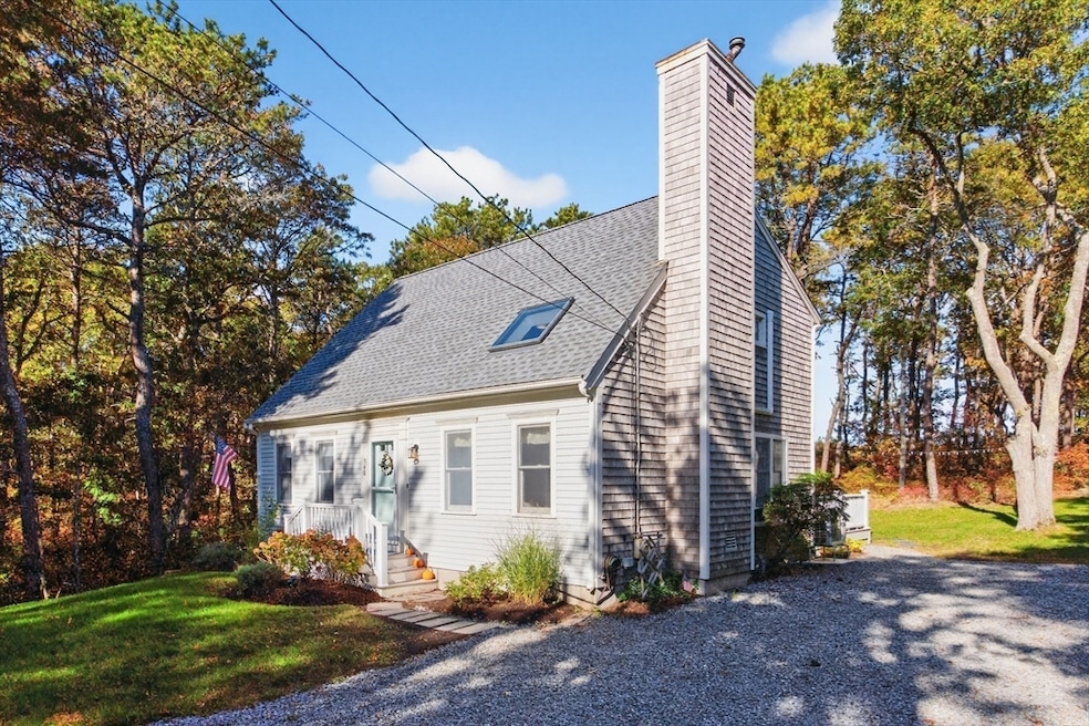

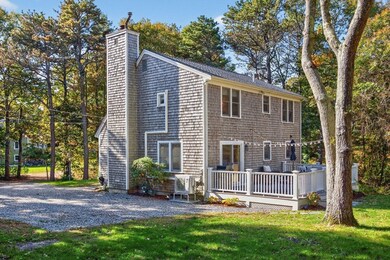
360 Center St Dennis Port, MA 02639
Dennis Port NeighborhoodEstimated payment $3,601/month
Highlights
- 0.63 Acre Lot
- Deck
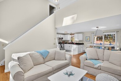
- Cathedral Ceiling
- Cape Cod Architecture
- Wooded Lot
- Wood Flooring
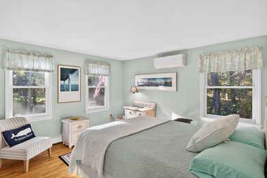
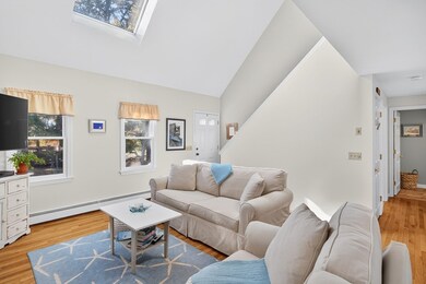
About This Home
Live the Cape Cod lifestyle year-round in this two bedroom, two bath home built in 1993 by Reef Builders. Perfect for entertaining, it features a large deck, refreshed landscaping with a new lawn and blue stone driveway, and a spacious yard ideal for summer BBQs, alfresco dining, and outdoor games. The surrounding landscape of native huckleberry, pine, and oak, interspersed with native grasses, creates a bird lover's paradise—bringing color, song, and life right to your doorstep. Designed with a 3-bedroom septic and potential to expand—including space for a garage—plus a very dry walk-out basement, this home offers flexibility for the future.

Home Details
Home Type
- Single Family
Est. Annual Taxes
- $2,239
Year Built
- Built in 1993
Lot Details
- 0.63 Acre Lot
- Gentle Sloping Lot
- Wooded Lot
Home Design
- Cape Cod Architecture
- Contemporary Architecture
- Shingle Roof
- Concrete Perimeter Foundation
Interior Spaces
- 1,199 Sq Ft Home
- Cathedral Ceiling
- 1 Fireplace
- Den
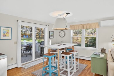
Kitchen
- Range
- Microwave
- Dishwasher
- Solid Surface Countertops
Flooring
- Wood
- Ceramic Tile
Bedrooms and Bathrooms
- 2 Bedrooms
- Primary Bedroom on Main
- 2 Full Bathrooms
Laundry
- Dryer
- Washer
Basement
- Walk-Out Basement
- Basement Fills Entire Space Under The House
- Laundry in Basement
Parking
- 4 Car Parking Spaces
- Unpaved Parking
- Open Parking
Outdoor Features
- Deck
Utilities
- Cooling Available
- Heat Pump System
- Baseboard Heating
- Gas Water Heater
- Private Sewer
Listing and Financial Details
- Assessor Parcel Number 2275322
Community Details
Overview
- No Home Owners Association
- Near Conservation Area
Recreation
- Bike Trail
Map
Home Values in the Area
Average Home Value in this Area
Tax History
| Year | Tax Paid | Tax Assessment Tax Assessment Total Assessment is a certain percentage of the fair market value that is determined by local assessors to be the total taxable value of land and additions on the property. | Land | Improvement |
|---|---|---|---|---|
| 2025 | $2,239 | $517,000 | $171,300 | $345,700 |
| 2024 | $2,226 | $507,100 | $174,400 | $332,700 |
| 2023 | $2,171 | $464,800 | $158,500 | $306,300 |
| 2022 | $2,163 | $386,300 | $158,700 | $227,600 |
| 2021 | $4,199 | $322,600 | $140,000 | $182,600 |
| 2020 | $1,904 | $312,100 | $140,000 | $172,100 |
| 2019 | $1,804 | $292,400 | $137,300 | $155,100 |
| 2018 | $1,750 | $276,000 | $130,700 | $145,300 |
| 2017 | $1,697 | $276,000 | $130,700 | $145,300 |
| 2016 | $1,753 | $268,400 | $145,200 | $123,200 |
| 2015 | $1,549 | $242,100 | $145,200 | $96,900 |
| 2014 | $1,438 | $226,500 | $116,200 | $110,300 |
Property History
| Date | Event | Price | List to Sale | Price per Sq Ft |
|---|---|---|---|---|
| 11/17/2025 11/17/25 | Pending | -- | -- | -- |
| 11/07/2025 11/07/25 | For Sale | $649,000 | 0.0% | $541 / Sq Ft |
| 11/03/2025 11/03/25 | Pending | -- | -- | -- |
| 10/26/2025 10/26/25 | For Sale | $649,000 | -- | $541 / Sq Ft |
Purchase History
| Date | Type | Sale Price | Title Company |
|---|---|---|---|
| Deed | $114,500 | -- |
Mortgage History
| Date | Status | Loan Amount | Loan Type |
|---|---|---|---|
| Open | $196,000 | No Value Available | |
| Closed | $189,375 | No Value Available | |
| Closed | $150,000 | No Value Available |
Source: MLS Property Information Network (MLS PIN)
MLS Number: 73447665
APN: DENN-000122-000000-000076
Disclaimer: Certain information contained herein is derived from information provided by parties other than Homes.com. All information provided is deemed reliable, but is not guaranteed to be accurate and should be independently verified.
![]() The property listing data and information, or the Images, set forth herein were provided to MLS Property Information Network, Inc. from third party sources, including sellers, lessors and public records, and were compiled by MLS Property Information Network, Inc. The property listing data and information, and the Images, are for the personal, non-commercial use of consumers having a good faith interest in purchasing or leasing listed properties of the type displayed to them and may not be used for any purpose other than to identify prospective properties which such consumers may have a good faith interest in purchasing or leasing. MLS Property Information Network, Inc. and its subscribers disclaim any and all representations and warranties as to the accuracy of the property listing data and information, or as to the accuracy of any of the Images, set forth herein.
The property listing data and information, or the Images, set forth herein were provided to MLS Property Information Network, Inc. from third party sources, including sellers, lessors and public records, and were compiled by MLS Property Information Network, Inc. The property listing data and information, and the Images, are for the personal, non-commercial use of consumers having a good faith interest in purchasing or leasing listed properties of the type displayed to them and may not be used for any purpose other than to identify prospective properties which such consumers may have a good faith interest in purchasing or leasing. MLS Property Information Network, Inc. and its subscribers disclaim any and all representations and warranties as to the accuracy of the property listing data and information, or as to the accuracy of any of the Images, set forth herein.
- 116 Searsville Rd
- 171 Searsville Rd
- 29 Highland St
- 20 Aunt Debbys Rd
- 3 Jennifer Ln
- 31 Duck Pond Rd
- 24 Indian Trail
- 78 Upper County Rd Unit A&B
- 78 Upper County Rd
- 11 Lane Rd
- 401 Main St Unit 201
- 401 Main St Unit 101
- 95 Center St
- 293 Main St
- 293 Main St
- 15 Yenom Rd
- 295 Main St
- 9 Country Ln
- 91 Depot Rd W
- 268 Main St