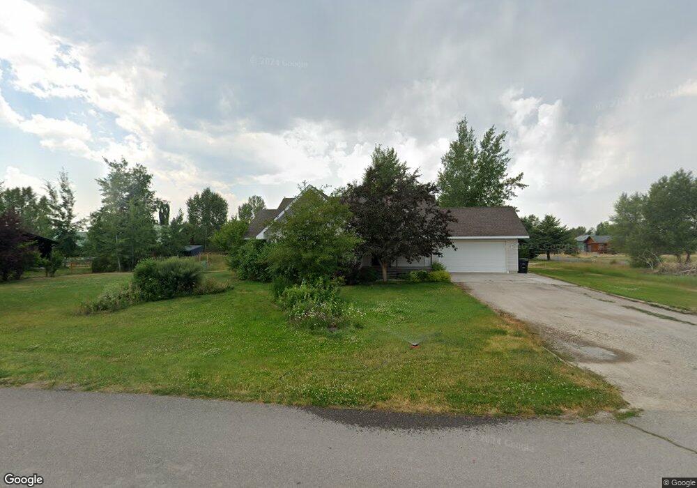
360 Chris Ln Unit WALLACE WAY LOT 9 BL Driggs, ID 83422
Estimated Value: $704,000 - $974,000
3
Beds
2
Baths
2,348
Sq Ft
$360/Sq Ft
Est. Value
About This Home
This home is located at 360 Chris Ln Unit WALLACE WAY LOT 9 BL, Driggs, ID 83422 and is currently estimated at $844,757, approximately $359 per square foot. 360 Chris Ln Unit WALLACE WAY LOT 9 BL is a home located in Teton County with nearby schools including Driggs Elementary School, Teton High School, and The Learning Academy of Teton Valley.
Ownership History
Date
Name
Owned For
Owner Type
Purchase Details
Closed on
Oct 17, 2006
Sold by
Irene M Bueler Revocable Trust
Bought by
Peterson Ryan and Peterson Daniela
Current Estimated Value
Home Financials for this Owner
Home Financials are based on the most recent Mortgage that was taken out on this home.
Original Mortgage
$210,400
Outstanding Balance
$125,550
Interest Rate
6.46%
Mortgage Type
New Conventional
Estimated Equity
$719,207
Create a Home Valuation Report for This Property
The Home Valuation Report is an in-depth analysis detailing your home's value as well as a comparison with similar homes in the area
Home Values in the Area
Average Home Value in this Area
Purchase History
| Date | Buyer | Sale Price | Title Company |
|---|---|---|---|
| Peterson Ryan | -- | -- |
Source: Public Records
Mortgage History
| Date | Status | Borrower | Loan Amount |
|---|---|---|---|
| Open | Peterson Ryan | $210,400 |
Source: Public Records
Tax History Compared to Growth
Tax History
| Year | Tax Paid | Tax Assessment Tax Assessment Total Assessment is a certain percentage of the fair market value that is determined by local assessors to be the total taxable value of land and additions on the property. | Land | Improvement |
|---|---|---|---|---|
| 2025 | $2,229 | $694,362 | $140,000 | $554,362 |
| 2024 | $2,057 | $654,163 | $125,000 | $529,163 |
| 2023 | $2,057 | $644,163 | $115,000 | $529,163 |
| 2022 | $2,211 | $542,388 | $100,000 | $442,388 |
| 2021 | $1,941 | $349,126 | $40,000 | $309,126 |
| 2020 | $1,862 | $275,628 | $35,000 | $240,628 |
| 2019 | $1,722 | $264,170 | $35,000 | $229,170 |
| 2018 | $1,554 | $236,295 | $30,000 | $206,295 |
| 2017 | $1,406 | $234,295 | $28,000 | $206,295 |
| 2016 | $1,235 | $202,498 | $25,000 | $177,498 |
| 2015 | $1,127 | $176,410 | $22,000 | $154,410 |
| 2011 | -- | $161,770 | $20,000 | $141,770 |
Source: Public Records
Map
Nearby Homes
- 624 Easy St
- 8720 Appaloosa Trail
- 570 Easy St
- 560 Appaloosa Trail
- 135 Sagewood Dr
- 135 Baywood Dr
- 110 Sagewood Dr
- 1021 Farmers Trail
- 430 N 5th E
- 398 Palisade Trail
- 70 Baywood Dr
- 525 Booshway
- 535 Palisade Trail
- 551 Palisade Trail
- 112 Aspen Meadows Rd Unit U36
- 652 Palisade Trail
- 668 Palisade Trail
- 101 Cobble Creek Ln
- 201 E Ross Ave Unit B103
- 201 E Ross Ave Unit D102