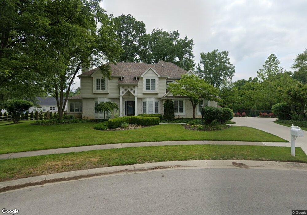
3608 Swallow Tail Ln Sylvania, OH 43560
Estimated Value: $438,000 - $502,000
4
Beds
3
Baths
3,304
Sq Ft
$142/Sq Ft
Est. Value
About This Home
This home is located at 3608 Swallow Tail Ln, Sylvania, OH 43560 and is currently estimated at $470,627, approximately $142 per square foot. 3608 Swallow Tail Ln is a home located in Lucas County with nearby schools including Stranahan Elementary School, Sylvania Timberstone Junior High School, and Sylvania Southview High School.
Ownership History
Date
Name
Owned For
Owner Type
Purchase Details
Closed on
Apr 26, 2011
Sold by
Cox Phillip F and Cox Vikki A
Bought by
Walerius Dennis E
Current Estimated Value
Home Financials for this Owner
Home Financials are based on the most recent Mortgage that was taken out on this home.
Original Mortgage
$266,000
Outstanding Balance
$184,858
Interest Rate
4.88%
Mortgage Type
New Conventional
Estimated Equity
$285,769
Purchase Details
Closed on
Mar 24, 1994
Sold by
Cox Ii Phillip F
Create a Home Valuation Report for This Property
The Home Valuation Report is an in-depth analysis detailing your home's value as well as a comparison with similar homes in the area
Home Values in the Area
Average Home Value in this Area
Purchase History
| Date | Buyer | Sale Price | Title Company |
|---|---|---|---|
| Walerius Dennis E | $280,000 | Louisville Title Agency For | |
| -- | -- | -- |
Source: Public Records
Mortgage History
| Date | Status | Borrower | Loan Amount |
|---|---|---|---|
| Open | Walerius Dennis E | $266,000 |
Source: Public Records
Tax History Compared to Growth
Tax History
| Year | Tax Paid | Tax Assessment Tax Assessment Total Assessment is a certain percentage of the fair market value that is determined by local assessors to be the total taxable value of land and additions on the property. | Land | Improvement |
|---|---|---|---|---|
| 2024 | $5,312 | $164,710 | $26,075 | $138,635 |
| 2023 | $11,929 | $159,215 | $25,095 | $134,120 |
| 2022 | $11,939 | $159,215 | $25,095 | $134,120 |
| 2021 | $12,229 | $159,215 | $25,095 | $134,120 |
| 2020 | $12,002 | $138,390 | $22,050 | $116,340 |
| 2019 | $11,444 | $136,990 | $22,050 | $114,940 |
| 2018 | $10,274 | $136,990 | $22,050 | $114,940 |
| 2017 | $9,864 | $107,345 | $27,405 | $79,940 |
| 2016 | $9,676 | $306,700 | $78,300 | $228,400 |
| 2015 | $9,125 | $306,700 | $78,300 | $228,400 |
| 2014 | $13,042 | $103,220 | $26,360 | $76,860 |
| 2013 | $8,695 | $103,220 | $26,360 | $76,860 |
Source: Public Records
Map
Nearby Homes
- 6606 Blossman Rd
- 3757 N Mccord Rd
- 3507 Indian Oaks Ln
- 3655 Woodspring Rd
- 3302 Zone Ave
- 3800 Harrowsfield Rd
- 3330 Wilford Dr
- 6537 Woodhall Dr Unit 8
- 4022 Stonehenge Dr Unit 4022
- 21 Shenandoah Cir
- 6657 Margate Blvd Unit 3
- 22 Shenandoah Cir
- 6243 Bonsels Pkwy
- 6537 Abbey Run Unit D5
- 6554 Abbey Run Unit 5
- 6718 5th Ave Unit F
- 6636 Kingsbridge Dr Unit 4
- 6626 Kingsbridge Dr Unit 4
- 4301 Appomattox Dr
- 2822 Page Lindsay Ln
- 3611 Swallow Tail Ln
- 3614 Swallow Tail Ln
- 3621 N Mccord Rd
- 3617 Swallow Tail Ln
- 3620 Swallow Tail Ln
- 3623 Swallow Tail Ln
- 6729 Sweet Bush Ct
- 3631 N Mccord Rd
- 6737 Sweet Bush Ct
- 6721 Sweet Bush Ct
- 3629 Swallow Tail Ln
- 6745 Sweet Bush Ct
- 3641 N Mccord Rd
- 3635 Swallow Tail Ln
- 3618 Wild Pheasant Ln
- 6715 Sweet Bush Ct
- 3641 Swallow Tail Ln
- 3626 Wild Pheasant Ln
- 3612 Wild Pheasant Ln
- 3540 N Mccord Rd