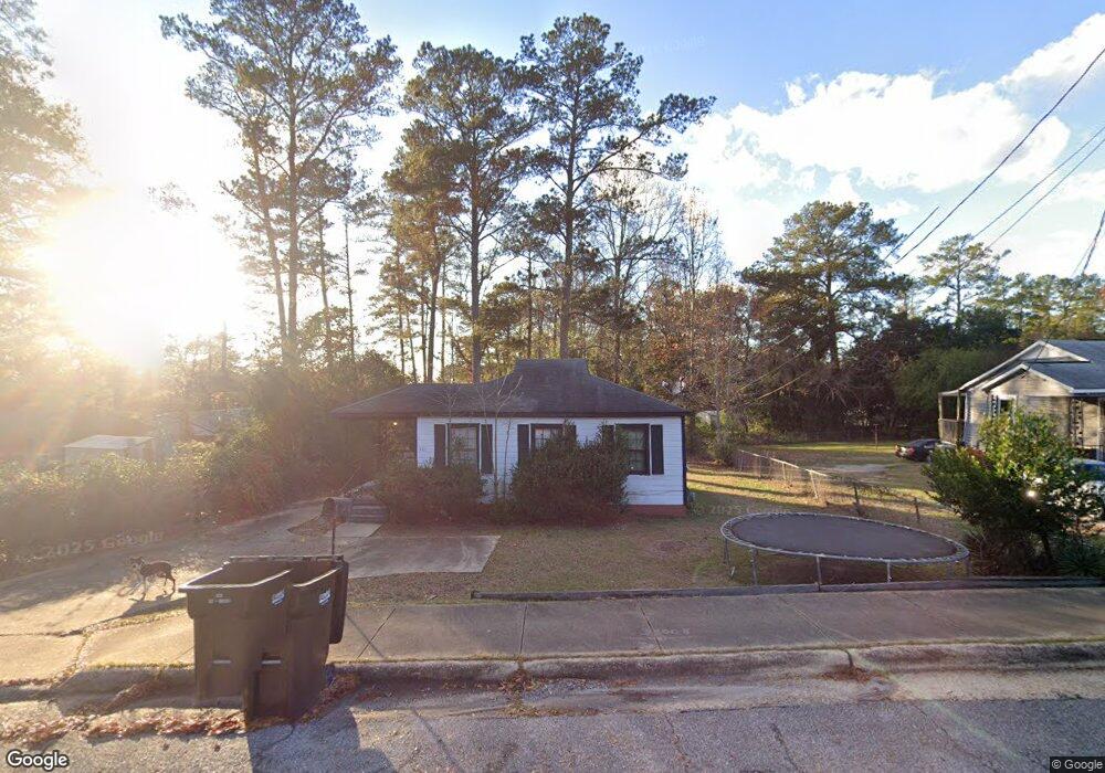
361 Northstar Dr Columbus, GA 31907
Eastern Columbus NeighborhoodEstimated Value: $83,000 - $104,000
2
Beds
2
Baths
729
Sq Ft
$126/Sq Ft
Est. Value
About This Home
This home is located at 361 Northstar Dr, Columbus, GA 31907 and is currently estimated at $91,649, approximately $125 per square foot. 361 Northstar Dr is a home located in Muscogee County with nearby schools including Dawson Elementary School, East Columbus Magnet Academy, and Kendrick High School.
Ownership History
Date
Name
Owned For
Owner Type
Purchase Details
Closed on
Mar 22, 2023
Sold by
Columbus 26 Partners Llc
Bought by
Macon Jh Sapir Llc
Current Estimated Value
Home Financials for this Owner
Home Financials are based on the most recent Mortgage that was taken out on this home.
Original Mortgage
$2,900,000
Outstanding Balance
$100,862
Interest Rate
6.12%
Mortgage Type
New Conventional
Estimated Equity
-$9,213
Purchase Details
Closed on
Dec 21, 2021
Sold by
Cf Properties Llc
Bought by
Columbus 26 Partners Llc
Purchase Details
Closed on
Jan 3, 2019
Sold by
Lr Partners Llc
Bought by
Cf Properties Llc
Purchase Details
Closed on
Jan 30, 2015
Sold by
Federal National Mortgage Association
Bought by
Lr Partners Llc
Purchase Details
Closed on
Dec 2, 2014
Sold by
Jpmorgan Chase Bank National A
Bought by
Federal National Mtg Associati
Create a Home Valuation Report for This Property
The Home Valuation Report is an in-depth analysis detailing your home's value as well as a comparison with similar homes in the area
Home Values in the Area
Average Home Value in this Area
Purchase History
| Date | Buyer | Sale Price | Title Company |
|---|---|---|---|
| Macon Jh Sapir Llc | $4,075,000 | -- | |
| Columbus 26 Partners Llc | $5,349,254 | -- | |
| Cf Properties Llc | $492,463 | -- | |
| Lr Partners Llc | $12,200 | -- | |
| Federal National Mtg Associati | $41,812 | -- | |
| Jpmorgan Chase Bank National A | $41,812 | -- | |
| Federal National Mtg Associati | $41,812 | -- |
Source: Public Records
Mortgage History
| Date | Status | Borrower | Loan Amount |
|---|---|---|---|
| Open | Macon Jh Sapir Llc | $2,900,000 |
Source: Public Records
Tax History Compared to Growth
Tax History
| Year | Tax Paid | Tax Assessment Tax Assessment Total Assessment is a certain percentage of the fair market value that is determined by local assessors to be the total taxable value of land and additions on the property. | Land | Improvement |
|---|---|---|---|---|
| 2025 | $1,130 | $28,864 | $6,268 | $22,596 |
| 2024 | $1,130 | $28,864 | $6,268 | $22,596 |
| 2023 | $1,080 | $27,408 | $6,268 | $21,140 |
| 2022 | $923 | $22,604 | $6,268 | $16,336 |
| 2021 | $402 | $9,840 | $6,268 | $3,572 |
| 2020 | $402 | $9,840 | $6,268 | $3,572 |
| 2019 | $403 | $9,840 | $6,268 | $3,572 |
| 2018 | $470 | $13,492 | $6,268 | $7,224 |
| 2017 | $525 | $12,776 | $6,268 | $6,508 |
| 2016 | $200 | $4,840 | $2,211 | $2,629 |
| 2015 | $303 | $8,000 | $2,211 | $5,789 |
| 2014 | $343 | $21,545 | $2,211 | $19,334 |
| 2013 | -- | $21,545 | $2,211 | $19,334 |
Source: Public Records
Map
Nearby Homes
- 5021 Shirley Ann Dr
- 5003 Shirley Ann Dr
- 100 R C Allen Dr
- 4846 Maplewood Dr
- 4801 Allen St
- 5235 Vincent Dr
- 418 Henson Ave
- 31 R C Allen Dr
- 391 & 401 Victoria Dr
- 4930 Capricorn Ct
- 702 Corley Dr
- 59 Apollo Dr
- 300 Jefferson Dr
- 644 Georgia Dr
- 533 Englewood Dr
- 4534 Sentry St
- 4516 Sims St
- 4414 Curry St
- 4917 Brightstar Ln
- 410 McCartha Dr
- 365 Northstar Dr
- 5033 Allen St
- 5027 Allen St
- 373 Northstar Dr
- 5021 Allen St
- 364 Northstar Dr
- 358 Northstar Dr
- 379 Northstar Dr
- 384 Mount Pleasant Ct
- 5015 Allen St
- 352 Northstar Dr
- 5034 Allen St
- 382 Mount Pleasant Ct
- 385 Northstar Dr
- 362 Mount Pleasant Dr
- 5022 Allen St
- 368 Mount Pleasant Dr
- 348 Northstar Dr
- 386 Mount Pleasant Ct
- 5005 Allen St