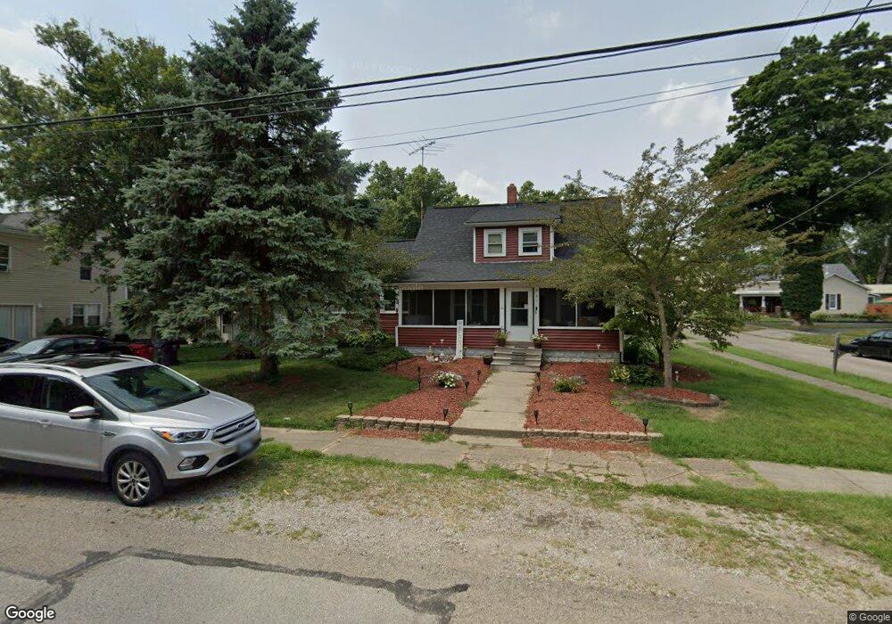
361 S High St Pataskala, OH 43062
Estimated Value: $236,792 - $312,000
3
Beds
1
Bath
1,224
Sq Ft
$217/Sq Ft
Est. Value
About This Home
This home is located at 361 S High St, Pataskala, OH 43062 and is currently estimated at $265,698, approximately $217 per square foot. 361 S High St is a home located in Licking County with nearby schools including Pataskala Elementary School, Etna Elementary School, and Watkins Middle School.
Ownership History
Date
Name
Owned For
Owner Type
Purchase Details
Closed on
Nov 10, 2004
Sold by
Cost Karen and Cost William L
Bought by
Smith Ronnie S
Current Estimated Value
Home Financials for this Owner
Home Financials are based on the most recent Mortgage that was taken out on this home.
Original Mortgage
$142,500
Interest Rate
8%
Mortgage Type
Unknown
Purchase Details
Closed on
Oct 2, 2000
Sold by
Hecker Ralph E
Bought by
Hicks Eleanor M
Create a Home Valuation Report for This Property
The Home Valuation Report is an in-depth analysis detailing your home's value as well as a comparison with similar homes in the area
Home Values in the Area
Average Home Value in this Area
Purchase History
| Date | Buyer | Sale Price | Title Company |
|---|---|---|---|
| Smith Ronnie S | $27,600 | Real Living Title | |
| Smith Ronnie S | $27,600 | Real Living Title | |
| Smith Ronnie S | $27,600 | Real Living Title | |
| Smith Ronnie S | $27,600 | Real Living Title | |
| Smith Ronnie S | $27,600 | Real Living Title | |
| Hicks Eleanor M | $119,000 | -- |
Source: Public Records
Mortgage History
| Date | Status | Borrower | Loan Amount |
|---|---|---|---|
| Previous Owner | Smith Ronnie S | $142,500 |
Source: Public Records
Tax History Compared to Growth
Tax History
| Year | Tax Paid | Tax Assessment Tax Assessment Total Assessment is a certain percentage of the fair market value that is determined by local assessors to be the total taxable value of land and additions on the property. | Land | Improvement |
|---|---|---|---|---|
| 2024 | $3,201 | $76,900 | $16,770 | $60,130 |
| 2023 | $3,198 | $76,900 | $16,770 | $60,130 |
| 2022 | $2,342 | $48,170 | $9,420 | $38,750 |
| 2021 | $2,412 | $48,170 | $9,420 | $38,750 |
| 2020 | $2,450 | $48,170 | $9,420 | $38,750 |
| 2019 | $2,012 | $36,540 | $7,840 | $28,700 |
| 2018 | $2,020 | $0 | $0 | $0 |
| 2017 | $2,147 | $0 | $0 | $0 |
| 2016 | $2,378 | $0 | $0 | $0 |
| 2015 | $2,292 | $0 | $0 | $0 |
| 2014 | $2,909 | $0 | $0 | $0 |
| 2013 | $2,476 | $0 | $0 | $0 |
Source: Public Records
Map
Nearby Homes
- 121 Granville St
- 475 Washington St
- 238 S Vine St
- 388 S Township Rd
- 164 W Mill St
- 81 Town St
- 204 S Fork Cir
- 303 Levi Dr Unit Lot 7
- 186 Markway Dr Unit Lot 12
- 305 Levi Dr Unit Lot 6
- 188 Markway Dr Unit Lot 13
- 601 Hannahs SW
- 0 Blacks Rd Unit 215031989
- 218 Blacks Rd
- 280 Blacks Rd
- 426 Waterlily Ln
- 282 River Forest Rd
- 360 Isaac Tharp St
- 364 Isaac Tharp St
- 2045 E Gardenia Dr
- 85 Granville St
- 371 S High St
- 63 Granville St
- 379 S High St
- 344 S High St
- 374 S High St
- 78 Granville St
- 91 Granville St
- 84 Granville St
- 55 Granville St
- 382 S High St
- 100 Granville St
- 56 Granville St
- 105 Granville St
- 47 Granville St
- 106 Granville St
- 394 S High St
- 50 Granville St
- 381 Wood St
- 44 Granville St Unit C