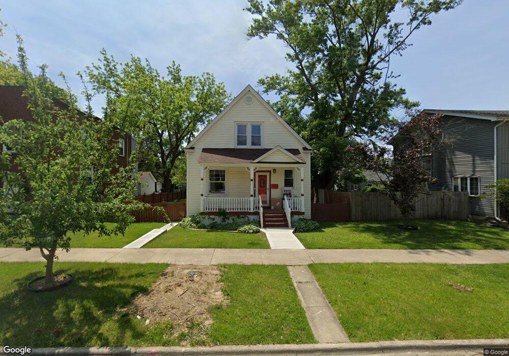
3615 213th Place Matteson, IL 60443
Old Matteson NeighborhoodEstimated Value: $150,000 - $187,000
3
Beds
2
Baths
888
Sq Ft
$193/Sq Ft
Est. Value
About This Home
This home is located at 3615 213th Place, Matteson, IL 60443 and is currently estimated at $171,706, approximately $193 per square foot. 3615 213th Place is a home located in Cook County with nearby schools including Illinois School, Matteson Elementary School, and Sauk Elementary School.
Ownership History
Date
Name
Owned For
Owner Type
Purchase Details
Closed on
Sep 25, 2025
Sold by
Postiglione Randall and Postiglione Scherrie
Bought by
Karaus Bruce and Pait Renee
Current Estimated Value
Home Financials for this Owner
Home Financials are based on the most recent Mortgage that was taken out on this home.
Original Mortgage
$167,200
Outstanding Balance
$167,200
Interest Rate
6.38%
Mortgage Type
New Conventional
Estimated Equity
$4,506
Purchase Details
Closed on
Jul 24, 2020
Sold by
Postiglione Randall
Bought by
Postiglione Randall and Postiglione Scherrie
Purchase Details
Closed on
Jul 26, 2005
Sold by
Martinez Emogene P
Bought by
Postiglione Randall
Home Financials for this Owner
Home Financials are based on the most recent Mortgage that was taken out on this home.
Original Mortgage
$143,000
Interest Rate
5.66%
Mortgage Type
Fannie Mae Freddie Mac
Create a Home Valuation Report for This Property
The Home Valuation Report is an in-depth analysis detailing your home's value as well as a comparison with similar homes in the area
Home Values in the Area
Average Home Value in this Area
Purchase History
| Date | Buyer | Sale Price | Title Company |
|---|---|---|---|
| Karaus Bruce | $176,000 | Acuity Title | |
| Postiglione Randall | -- | None Available | |
| Postiglione Randall | $143,000 | Stewart Title Of Illinois |
Source: Public Records
Mortgage History
| Date | Status | Borrower | Loan Amount |
|---|---|---|---|
| Open | Karaus Bruce | $167,200 | |
| Previous Owner | Postiglione Randall | $143,000 |
Source: Public Records
Tax History Compared to Growth
Tax History
| Year | Tax Paid | Tax Assessment Tax Assessment Total Assessment is a certain percentage of the fair market value that is determined by local assessors to be the total taxable value of land and additions on the property. | Land | Improvement |
|---|---|---|---|---|
| 2024 | $2,633 | $13,000 | $2,640 | $10,360 |
| 2023 | -- | $13,000 | $2,640 | $10,360 |
| 2022 | $0 | $6,400 | $2,310 | $4,090 |
| 2021 | $415 | $6,399 | $2,310 | $4,089 |
| 2020 | $415 | $6,399 | $2,310 | $4,089 |
| 2019 | $875 | $7,864 | $2,145 | $5,719 |
| 2018 | $869 | $7,864 | $2,145 | $5,719 |
| 2017 | $2,230 | $7,864 | $2,145 | $5,719 |
| 2016 | $2,707 | $8,003 | $1,980 | $6,023 |
| 2015 | $2,622 | $8,003 | $1,980 | $6,023 |
| 2014 | $2,566 | $8,003 | $1,980 | $6,023 |
| 2013 | $2,482 | $8,379 | $1,980 | $6,399 |
Source: Public Records
Map
Nearby Homes
- 3712 214th St
- 3727 214th Place Unit 2
- 3704 215th St Unit 205
- 21209 Oak St
- 21142 Locust St
- 21607 Main St
- 3809 215th St
- 549 Homan Ave
- 3718 211th Place
- 3919 214th St
- 3817 216th Place
- 508 Davis St
- 3865 216th St
- 21612 Wildflower Rd Unit 113-4
- 307 Gettysburg St
- 21635 Dogwood Rd Unit 1165
- 410 Gettysburg St
- 500 Antietam St
- 120 Indiana St
- 338 Waldmann Dr
- 3619 213th Place
- 21342 Main St
- 3603 213th Place
- 3627 213th Place
- 3612 214th St
- 3608 214th St
- 3602 Main St
- 3622 214th St
- 3631 213th Place
- 21322 Main St
- 3620 213th Place
- 3602 214th St
- 3624 213th Place
- 3630 213th Place
- 3551 213th Place
- 21349 Locust St
- 21349 Locust St
- 21325 Main St
- 3605 214th St
- 3605 214th St