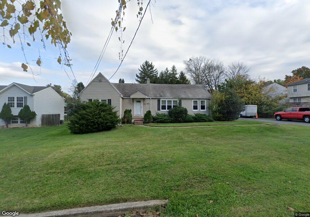
3619 Chapman Rd Randallstown, MD 21133
Estimated Value: $312,000 - $437,000
--
Bed
2
Baths
1,426
Sq Ft
$249/Sq Ft
Est. Value
About This Home
This home is located at 3619 Chapman Rd, Randallstown, MD 21133 and is currently estimated at $354,634, approximately $248 per square foot. 3619 Chapman Rd is a home located in Baltimore County with nearby schools including Randallstown Elementary School, Deer Park Middle Magnet School, and Randallstown High School.
Ownership History
Date
Name
Owned For
Owner Type
Purchase Details
Closed on
Jun 8, 1999
Sold by
Covington Kathy E
Bought by
Brown Lee T and Brown Hester L
Current Estimated Value
Purchase Details
Closed on
Jun 29, 1998
Sold by
Covington Kathy
Bought by
Covington Kathy E
Purchase Details
Closed on
Sep 16, 1996
Sold by
Covington Kathy
Bought by
Covington Kathy
Purchase Details
Closed on
Apr 10, 1996
Sold by
Harvey Ethel L Harvey Emor
Bought by
Covington Kathy
Create a Home Valuation Report for This Property
The Home Valuation Report is an in-depth analysis detailing your home's value as well as a comparison with similar homes in the area
Home Values in the Area
Average Home Value in this Area
Purchase History
| Date | Buyer | Sale Price | Title Company |
|---|---|---|---|
| Brown Lee T | $95,500 | -- | |
| Covington Kathy E | -- | -- | |
| Covington Kathy | $60,000 | -- | |
| Covington Kathy | -- | -- |
Source: Public Records
Tax History Compared to Growth
Tax History
| Year | Tax Paid | Tax Assessment Tax Assessment Total Assessment is a certain percentage of the fair market value that is determined by local assessors to be the total taxable value of land and additions on the property. | Land | Improvement |
|---|---|---|---|---|
| 2025 | $2,881 | $204,467 | -- | -- |
| 2024 | $2,881 | $172,200 | $65,000 | $107,200 |
| 2023 | $1,000 | $169,233 | $0 | $0 |
| 2022 | $1,277 | $166,267 | $0 | $0 |
| 2021 | $1,182 | $163,300 | $65,000 | $98,300 |
| 2020 | $1,182 | $157,733 | $0 | $0 |
| 2019 | $635 | $152,167 | $0 | $0 |
| 2018 | $558 | $146,600 | $65,000 | $81,600 |
| 2017 | $1,083 | $144,233 | $0 | $0 |
| 2016 | $1,084 | $141,867 | $0 | $0 |
| 2015 | $1,084 | $139,500 | $0 | $0 |
| 2014 | $1,084 | $139,500 | $0 | $0 |
Source: Public Records
Map
Nearby Homes
- 9208A Liberty Rd
- 9202 Samoset Rd
- 9210 Liberty Rd
- 9406 Painted Tree Dr
- 9401 Summer Squal Dr
- 9302 Silver Charm Dr
- 3816 Cassandra Rd
- 3805 Terka Cir
- 3506 Bayer Ave
- 3854 Terka Cir
- 3705 Allenswood Ct
- 3402 Offutt Rd
- 9012 Allenswood Rd
- 9044 Allenswood Rd
- 3332 Offutt Rd
- 3418 Carroll Ave
- 9112 Meadow Heights Rd
- 3320 Offutt Rd
- 4108 Brown Bark Cir
- 9311 Colorado Ave
- 3621 Chapman Rd
- 4 Chapmanview Ct
- 2 Chapmanview Ct
- 9221 Samoset Rd
- 6 Chapmanview Ct
- 9219 Samoset Rd
- 8 Chapmanview Ct
- 9217 Samoset Rd
- 3618 Chapman Rd
- 9300 Samoset Rd
- 9220 Samoset Rd
- 3616 Chapman Rd
- 3613 Chapman Rd
- 9215 Samoset Rd
- 9218 Samoset Rd
- 3614 Chapman Rd
- 9302 Samoset Rd
- 3703 Collier Rd
- 3702 Collier Rd
- 9307 Samoset Rd