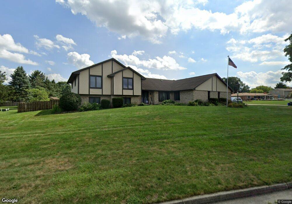
362 Bronston Trail Beavercreek, OH 45430
Estimated Value: $430,000 - $554,000
4
Beds
4
Baths
2,900
Sq Ft
$164/Sq Ft
Est. Value
About This Home
This home is located at 362 Bronston Trail, Beavercreek, OH 45430 and is currently estimated at $474,938, approximately $163 per square foot. 362 Bronston Trail is a home located in Greene County with nearby schools including Fairbrook Elementary School, Herman K Ankeney Middle School, and Beavercreek High School.
Ownership History
Date
Name
Owned For
Owner Type
Purchase Details
Closed on
Sep 30, 2019
Sold by
Bechtold Ronald K and Baker Julia Anne
Bought by
Lee Mun K and Lee Julia D
Current Estimated Value
Home Financials for this Owner
Home Financials are based on the most recent Mortgage that was taken out on this home.
Original Mortgage
$210,000
Outstanding Balance
$139,647
Interest Rate
3.4%
Mortgage Type
New Conventional
Estimated Equity
$335,291
Purchase Details
Closed on
Sep 28, 2017
Sold by
Bechtold Trust
Bought by
Bechtold Trust
Purchase Details
Closed on
Sep 30, 2008
Sold by
Bechtold Ronald K and Bechtold Irene L
Bought by
Bechtold Irene L and Bechtold Ronald K
Purchase Details
Closed on
Oct 29, 1999
Sold by
Pansza Anthony J and Pansza Brenda R
Bought by
Bechtold Ronald K and Bechtold Irene L
Home Financials for this Owner
Home Financials are based on the most recent Mortgage that was taken out on this home.
Original Mortgage
$213,750
Interest Rate
7.78%
Create a Home Valuation Report for This Property
The Home Valuation Report is an in-depth analysis detailing your home's value as well as a comparison with similar homes in the area
Home Values in the Area
Average Home Value in this Area
Purchase History
| Date | Buyer | Sale Price | Title Company |
|---|---|---|---|
| Lee Mun K | $315,000 | Landmark Title Agency Inc | |
| Bechtold Trust | -- | -- | |
| Bechtold Irene L | -- | Attorney | |
| Bechtold Ronald K | $237,500 | -- |
Source: Public Records
Mortgage History
| Date | Status | Borrower | Loan Amount |
|---|---|---|---|
| Open | Lee Mun K | $210,000 | |
| Previous Owner | Bechtold Ronald K | $213,750 |
Source: Public Records
Tax History Compared to Growth
Tax History
| Year | Tax Paid | Tax Assessment Tax Assessment Total Assessment is a certain percentage of the fair market value that is determined by local assessors to be the total taxable value of land and additions on the property. | Land | Improvement |
|---|---|---|---|---|
| 2024 | $7,860 | $120,390 | $28,210 | $92,180 |
| 2023 | $7,860 | $120,390 | $28,210 | $92,180 |
| 2022 | $7,419 | $100,320 | $21,700 | $78,620 |
| 2021 | $7,269 | $100,320 | $21,700 | $78,620 |
| 2020 | $5,901 | $100,320 | $21,700 | $78,620 |
| 2019 | $5,901 | $82,540 | $17,930 | $64,610 |
| 2018 | $5,208 | $82,540 | $17,930 | $64,610 |
| 2017 | $5,120 | $82,540 | $17,930 | $64,610 |
| 2016 | $5,392 | $82,760 | $17,930 | $64,830 |
| 2015 | $5,360 | $82,760 | $17,930 | $64,830 |
| 2014 | $5,279 | $82,760 | $17,930 | $64,830 |
Source: Public Records
Map
Nearby Homes
- 170 Saundra Ct
- 97 Apple Blossom Place
- 3961 Ephrata Ct
- 2658 Tompkins Dr
- 185 Rosillo Dr
- 65 Aberdeen Village Dr Unit 65
- 4174 White Hawk Ct
- 4134 Cambridge Trail
- 24 Rosell Dr
- 3978 Indian Ripple Rd
- 564 Plattner Trail
- 4310 Straight Arrow Rd Unit 4310
- 4324 Straight Arrow Rd Unit 4324
- 611 Cape Cod Ct
- 4011 Willow Run Dr
- 615 Bendwood Way
- 520 Vineland Trail
- 641 Angler Ct
- 3917 E Summit Ridge Dr
- 4485 Longmeadow Ln
- 352 Bronston Trail
- 390 Bronston Trail
- 4079 W Kenderton Trail
- 4088 W Kenderton Trail
- 342 Bronston Trail
- 349 Kenderton Trail
- 4102 Pennywood Dr
- 369 Bronston Trail
- 4078 W Kenderton Trail
- 339 Kenderton Trail
- 389 Bronston Trail
- 332 Bronston Trail
- 4112 Pennywood Dr
- 460 Ramsgate Dr
- 4017 S Emerald Ct
- 454 Ramsgate Dr
- 446 Ramsgate Dr
- 4105 Pennywood Dr
- 322 Bronston Trail
- 4023 S Emerald Ct