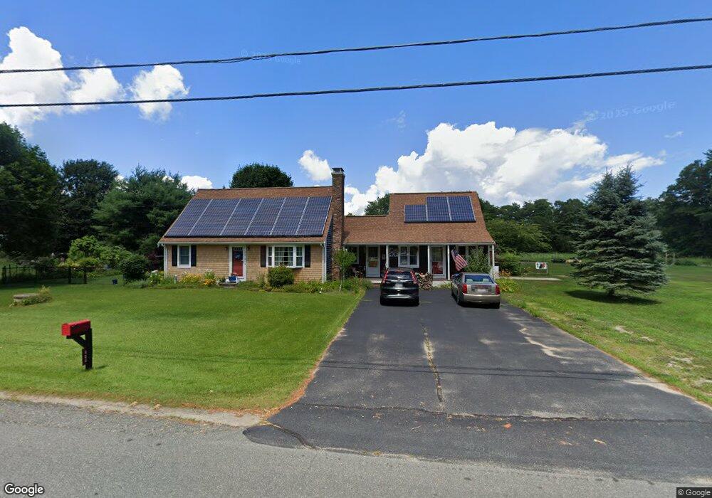
362 Mendell Rd Rochester, MA 02770
Estimated Value: $567,000 - $654,000
4
Beds
2
Baths
1,870
Sq Ft
$336/Sq Ft
Est. Value
About This Home
This home is located at 362 Mendell Rd, Rochester, MA 02770 and is currently estimated at $629,181, approximately $336 per square foot. 362 Mendell Rd is a home located in Plymouth County with nearby schools including Rochester Memorial School and Old Rochester Regional High School.
Ownership History
Date
Name
Owned For
Owner Type
Purchase Details
Closed on
May 8, 2002
Sold by
Ferro Jacinto A and Ferro Louise R
Bought by
Zantrofski David A and Zantrofski Tina M
Current Estimated Value
Purchase Details
Closed on
Aug 28, 1995
Sold by
Martin Brenda J
Bought by
Ferro Jacinto A and Ferro Louise R
Create a Home Valuation Report for This Property
The Home Valuation Report is an in-depth analysis detailing your home's value as well as a comparison with similar homes in the area
Home Values in the Area
Average Home Value in this Area
Purchase History
| Date | Buyer | Sale Price | Title Company |
|---|---|---|---|
| Zantrofski David A | $217,000 | -- | |
| Ferro Jacinto A | $126,500 | -- | |
| Martin Brenda J | $13,428 | -- |
Source: Public Records
Mortgage History
| Date | Status | Borrower | Loan Amount |
|---|---|---|---|
| Open | Martin Brenda J | $30,000 | |
| Open | Martin Brenda J | $119,000 | |
| Closed | Martin Brenda J | $15,500 |
Source: Public Records
Tax History Compared to Growth
Tax History
| Year | Tax Paid | Tax Assessment Tax Assessment Total Assessment is a certain percentage of the fair market value that is determined by local assessors to be the total taxable value of land and additions on the property. | Land | Improvement |
|---|---|---|---|---|
| 2025 | $5,524 | $510,500 | $165,600 | $344,900 |
| 2024 | $5,426 | $490,600 | $157,800 | $332,800 |
| 2023 | $5,236 | $441,100 | $157,800 | $283,300 |
| 2022 | $5,211 | $409,000 | $192,300 | $216,700 |
| 2021 | $5,094 | $381,000 | $181,400 | $199,600 |
| 2020 | $4,992 | $370,300 | $176,000 | $194,300 |
| 2019 | $4,571 | $326,500 | $165,100 | $161,400 |
| 2018 | $4,491 | $318,300 | $148,700 | $169,600 |
| 2017 | $4,049 | $281,400 | $122,600 | $158,800 |
| 2016 | $3,885 | $277,300 | $124,100 | $153,200 |
| 2015 | $3,783 | $268,900 | $124,100 | $144,800 |
| 2014 | $3,789 | $273,600 | $120,800 | $152,800 |
Source: Public Records
Map
Nearby Homes
- 1-3 Doctor Hickey Ln
- 4 Sarahbeth Ln Unit 1
- 1 Rounseville Rd
- 709 Walnut Plain Rd
- 0 Rounseville Rd
- 4 Hayley Cir
- 2 Hayley Cir
- 21 Robinson Rd
- 0-A3 Marys Pond Rd
- 0-A4 Marys Pond Rd
- 150 Ryder Rd
- 9 Hathaway Pond Cir
- 57 Hathaway Pond Cir Unit 57
- 714 Snipatuit Rd
- 170 Dexter Ln
- 562 North Ave
- 82 Pierce St
- 1 Clems Way
- 21 Bennett Rd
- 15 Cross Rd