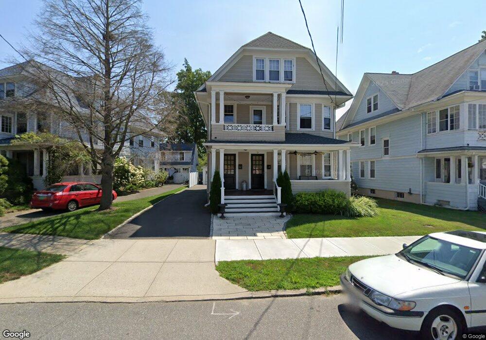
362 Midland St Unit 366 Bridgeport, CT 06605
Black Rock NeighborhoodEstimated Value: $604,832 - $912,000
5
Beds
3
Baths
3,352
Sq Ft
$230/Sq Ft
Est. Value
About This Home
This home is located at 362 Midland St Unit 366, Bridgeport, CT 06605 and is currently estimated at $769,458, approximately $229 per square foot. 362 Midland St Unit 366 is a home located in Fairfield County with nearby schools including Black Rock School, Bassick High School, and Great Oaks Charter School Bridgeport.
Ownership History
Date
Name
Owned For
Owner Type
Purchase Details
Closed on
Jul 26, 2016
Sold by
Dierna Marcus
Bought by
Dias Carlos and Dias Luisa
Current Estimated Value
Home Financials for this Owner
Home Financials are based on the most recent Mortgage that was taken out on this home.
Original Mortgage
$242,900
Outstanding Balance
$194,553
Interest Rate
3.6%
Mortgage Type
Unknown
Estimated Equity
$574,905
Purchase Details
Closed on
Oct 3, 2007
Sold by
Valko Elizabeth
Bought by
Dierna Marcus
Create a Home Valuation Report for This Property
The Home Valuation Report is an in-depth analysis detailing your home's value as well as a comparison with similar homes in the area
Home Values in the Area
Average Home Value in this Area
Purchase History
| Date | Buyer | Sale Price | Title Company |
|---|---|---|---|
| Dias Carlos | $347,000 | -- | |
| Dias Carlos | $347,000 | -- | |
| Dierna Marcus | $330,900 | -- | |
| Dierna Marcus | $330,900 | -- |
Source: Public Records
Mortgage History
| Date | Status | Borrower | Loan Amount |
|---|---|---|---|
| Open | Dierna Marcus | $242,900 | |
| Closed | Dierna Marcus | $242,900 | |
| Previous Owner | Dierna Marcus | $250,970 |
Source: Public Records
Tax History Compared to Growth
Tax History
| Year | Tax Paid | Tax Assessment Tax Assessment Total Assessment is a certain percentage of the fair market value that is determined by local assessors to be the total taxable value of land and additions on the property. | Land | Improvement |
|---|---|---|---|---|
| 2025 | $13,139 | $302,400 | $157,310 | $145,090 |
| 2024 | $13,139 | $302,400 | $157,310 | $145,090 |
| 2023 | $13,139 | $302,400 | $157,310 | $145,090 |
| 2022 | $13,139 | $302,400 | $157,310 | $145,090 |
| 2021 | $13,139 | $302,400 | $157,310 | $145,090 |
| 2020 | $12,751 | $236,180 | $115,170 | $121,010 |
| 2019 | $12,751 | $236,180 | $115,170 | $121,010 |
| 2018 | $12,841 | $236,180 | $115,170 | $121,010 |
| 2017 | $12,841 | $236,180 | $115,170 | $121,010 |
| 2016 | $12,841 | $236,180 | $115,170 | $121,010 |
| 2015 | $12,520 | $296,690 | $125,000 | $171,690 |
| 2014 | $12,520 | $296,690 | $125,000 | $171,690 |
Source: Public Records
Map
Nearby Homes
- 75 Homestead Ave Unit 77
- 39 Jetland Place Unit 41
- 317 Brewster St
- 105 Fox St Unit 107
- 554 Brewster St Unit 4
- 26 Rowsley St Unit 3
- 165 Bennett St
- 37 Rowsley St Unit 6
- 855 Brewster St Unit 857
- 361 Riverside Dr
- 166 Alfred St
- 0 Battery Park Dr
- 167 Scofield Ave
- 188 Monroe St Unit 190
- 2180 Kings Hwy Unit 1
- 82 Waldorf Ave
- 135 Whittier St
- 25 Whittier St
- 31 Whittier St
- 96 Clinton St
- 358 Midland St
- 356 Midland St Unit 358
- 356 Midland St Unit 2
- 386 Midland St Unit 388
- 373 Midland St Unit 375
- 466 Courtland Ave Unit 2
- 420 Courtland Ave
- 464 Courtland Ave Unit 466
- 334 Midland St Unit 336
- 474 Courtland Ave
- 398 Midland St
- 408 Courtland Ave
- 423 Courtland Ave Unit 425
- 425 Courtland Ave Unit 2-3
- 423 Courtland Ave Unit 1
- 423 Courtland Ave Unit 2-3
- 482 Courtland Ave
- 326 Midland St
- 465 Courtland Ave
- 1 Garden Terrace