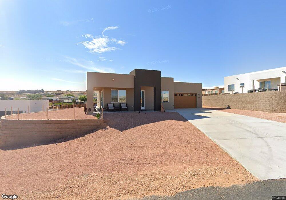
362 Schoppman Ln Marble Canyon, AZ 86036
Estimated Value: $474,000 - $593,163
--
Bed
--
Bath
--
Sq Ft
10,454
Sq Ft Lot
About This Home
This home is located at 362 Schoppman Ln, Marble Canyon, AZ 86036 and is currently estimated at $508,541. 362 Schoppman Ln is a home with nearby schools including Fredonia Elementary School and Fredonia High School.
Ownership History
Date
Name
Owned For
Owner Type
Purchase Details
Closed on
Oct 25, 2021
Sold by
Mjq Properties Llc
Bought by
Osborn Gena L and Osborn Michael S
Current Estimated Value
Home Financials for this Owner
Home Financials are based on the most recent Mortgage that was taken out on this home.
Original Mortgage
$183,500
Outstanding Balance
$139,457
Interest Rate
2.23%
Mortgage Type
New Conventional
Estimated Equity
$369,084
Purchase Details
Closed on
Oct 15, 2019
Sold by
Greenhaven Development Corporation
Bought by
Mjq Properties Llc
Create a Home Valuation Report for This Property
The Home Valuation Report is an in-depth analysis detailing your home's value as well as a comparison with similar homes in the area
Home Values in the Area
Average Home Value in this Area
Purchase History
| Date | Buyer | Sale Price | Title Company |
|---|---|---|---|
| Osborn Gena L | $388,500 | Pioneer Title | |
| Mjq Properties Llc | $32,500 | First American Title Ins Co |
Source: Public Records
Mortgage History
| Date | Status | Borrower | Loan Amount |
|---|---|---|---|
| Open | Osborn Gena L | $183,500 |
Source: Public Records
Tax History Compared to Growth
Tax History
| Year | Tax Paid | Tax Assessment Tax Assessment Total Assessment is a certain percentage of the fair market value that is determined by local assessors to be the total taxable value of land and additions on the property. | Land | Improvement |
|---|---|---|---|---|
| 2025 | $2,210 | $37,556 | -- | -- |
| 2024 | $2,210 | $35,943 | -- | -- |
| 2023 | $464 | $6,480 | $0 | $0 |
| 2022 | $464 | $4,182 | $0 | $0 |
| 2021 | $585 | $5,228 | $0 | $0 |
| 2020 | $593 | $6,150 | $0 | $0 |
| 2019 | $534 | $5,535 | $0 | $0 |
| 2018 | $537 | $5,288 | $0 | $0 |
| 2017 | $518 | $4,598 | $0 | $0 |
| 2016 | $448 | $4,598 | $0 | $0 |
| 2015 | $518 | $4,904 | $0 | $0 |
Source: Public Records
Map
Nearby Homes
- 130 Tek Ct Unit 95
- 30 Tek Ct
- 265 Myrtle Dr
- 142 Dunn Dr
- 12 Sumner Cove
- 665 N Anasazi Dr Unit Lot 19
- 142 Bryce Canyon Dr
- 152 Bryce Canyon Dr
- 451 Ticaboo Canyon Dr Unit 33
- 461 Ticaboo Canyon Dr Unit 34
- 8.35 Acres S Parcel Rainbow Dr
- 1334 E Rock Ledge Ln
- 1260 Patrick Henry Ct
- 1140 Independence
- 1140 S Independence Dr
- 1100 Revolution Way
- 933 Freedom
- 27 Independance Way
- 1107 E Old Glory Way
- 715 E Liberty Bell Ct
- 332 Schoppman Ln
- 392 Schoppman Ln
- 93 Tek Ct
- 325 Glen Dr
- 701 Red Canyon Dr
- 711 Red Canyon Dr
- 312 Schoppman Ln
- 70 N Wahweap Dr
- 232 N Wahweap Dr
- 618 Red Canyon Dr
- 36 N Wahweap Dr
- 22 Myrtle Dr
- 262 Schoppman Ln
- 218 S Wahweap Dr
- 261 S Wahweap Dr
- 242 Schoppman Ln
- 85 Schoppman Ln
- 232 Schoppman Ln
- 52 Last Chance Bay Unit 37
- 72 Last Chance Bay Unit 38