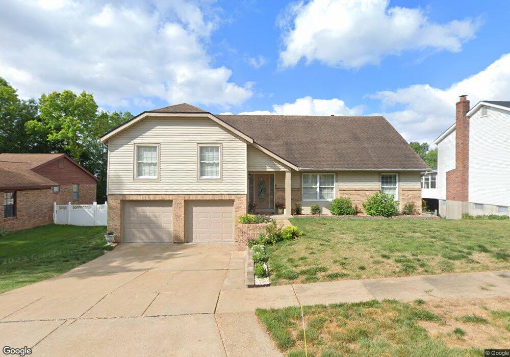
3620 Amber Ridge Ct Saint Louis, MO 63129
Estimated Value: $374,000 - $433,000
5
Beds
4
Baths
2,912
Sq Ft
$142/Sq Ft
Est. Value
About This Home
This home is located at 3620 Amber Ridge Ct, Saint Louis, MO 63129 and is currently estimated at $413,639, approximately $142 per square foot. 3620 Amber Ridge Ct is a home located in St. Louis County with nearby schools including Blades Elementary School, Bernard Middle School, and Oakville Senior High School.
Ownership History
Date
Name
Owned For
Owner Type
Purchase Details
Closed on
Jan 10, 2007
Sold by
Bank Of America Na
Bought by
Karalic Safet and Karalic Sauda
Current Estimated Value
Home Financials for this Owner
Home Financials are based on the most recent Mortgage that was taken out on this home.
Original Mortgage
$31,800
Outstanding Balance
$12,881
Interest Rate
6.09%
Mortgage Type
Credit Line Revolving
Estimated Equity
$400,758
Purchase Details
Closed on
Mar 18, 2005
Sold by
Sophie Frank L and Sophie Joyce A
Bought by
Ahmed Mohammed
Home Financials for this Owner
Home Financials are based on the most recent Mortgage that was taken out on this home.
Original Mortgage
$228,000
Interest Rate
5.71%
Mortgage Type
Purchase Money Mortgage
Create a Home Valuation Report for This Property
The Home Valuation Report is an in-depth analysis detailing your home's value as well as a comparison with similar homes in the area
Home Values in the Area
Average Home Value in this Area
Purchase History
| Date | Buyer | Sale Price | Title Company |
|---|---|---|---|
| Karalic Safet | $212,000 | First Amer Title Of St Louis | |
| Ahmed Mohammed | $300,000 | -- |
Source: Public Records
Mortgage History
| Date | Status | Borrower | Loan Amount |
|---|---|---|---|
| Open | Karalic Safet | $31,800 | |
| Open | Karalic Safet | $169,600 | |
| Previous Owner | Ahmed Mohammed | $228,000 | |
| Closed | Ahmed Mohammed | $57,000 |
Source: Public Records
Tax History Compared to Growth
Tax History
| Year | Tax Paid | Tax Assessment Tax Assessment Total Assessment is a certain percentage of the fair market value that is determined by local assessors to be the total taxable value of land and additions on the property. | Land | Improvement |
|---|---|---|---|---|
| 2025 | $4,211 | $67,730 | $22,150 | $45,580 |
| 2024 | $4,211 | $62,740 | $14,230 | $48,510 |
| 2023 | $4,158 | $62,740 | $14,230 | $48,510 |
| 2022 | $3,680 | $55,790 | $10,280 | $45,510 |
| 2021 | $3,561 | $55,790 | $10,280 | $45,510 |
| 2020 | $3,709 | $55,290 | $9,500 | $45,790 |
| 2019 | $3,698 | $55,290 | $9,500 | $45,790 |
| 2018 | $3,716 | $50,160 | $7,920 | $42,240 |
| 2017 | $3,710 | $50,160 | $7,920 | $42,240 |
| 2016 | $3,821 | $49,570 | $7,920 | $41,650 |
| 2015 | $3,507 | $49,570 | $7,920 | $41,650 |
| 2014 | $3,110 | $43,470 | $6,020 | $37,450 |
Source: Public Records
Map
Nearby Homes
- 4121 Old Baumgartner Rd
- 5824 Bridleford Ln
- 5827 Bridleford Ln
- 5896 Rockland Ln
- 5735 Dove Meadow Ln
- 4251 Green Grove Ct
- 4694 Baumgartner Rd
- 5600 Wickershire Ln
- 5524 Providence Place Dr
- 5942 Hawkins Fuchs Rd
- 6055 Bayou Bend Ct
- 6006 Grand Marnier Dr
- 5327 Crowndun Dr
- 5908 Oakville Woods Place
- 2279 Cessna Dr
- 5581 Baronridge Dr Unit 5
- 5569 Baronridge Dr Unit 10
- 5227 Patterson Rd
- 4357 Bristol View Ct
- 4374 Bristol View Ct
- 3616 Amber Ridge Ct
- 3624 Amber Ridge Ct
- 3612 Amber Ridge Ct
- 3619 Amber Ridge Ct
- 3623 Amber Ridge Ct
- 3615 Amber Ridge Ct
- 3608 Amber Ridge Ct
- 3631 Amber Ridge Ct
- 3609 Amber Ridge Ct
- 3620 Whispering Ridge Ln
- 3624 Whispering Ridge Ln
- 3614 Whispering Ridge Ln
- 3610 Whispering Ridge Ln
- 3632 Whispering Ridge Ln
- 3636 Whispering Ridge Ln
- 3623 Whispering Ridge Ln
- 3627 Whispering Ridge Ln
- 3619 Whispering Ridge Ln
- 3615 Whispering Ridge Ln
- 3640 Whispering Ridge Ln