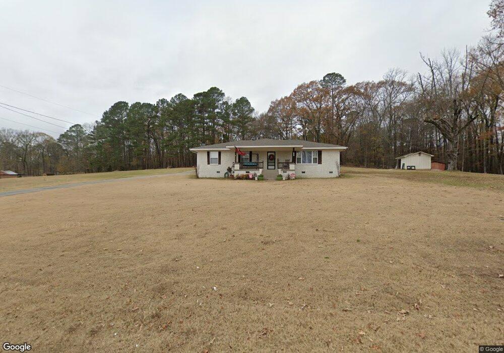
3621 S Highway 229 Benton, AR 72015
Estimated Value: $208,364 - $253,000
3
Beds
2
Baths
1,566
Sq Ft
$144/Sq Ft
Est. Value
About This Home
This home is located at 3621 S Highway 229, Benton, AR 72015 and is currently estimated at $226,091, approximately $144 per square foot. 3621 S Highway 229 is a home located in Saline County with nearby schools including Westbrook Elementary School, Harmony Grove Middle School, and Harmony Grove High School.
Ownership History
Date
Name
Owned For
Owner Type
Purchase Details
Closed on
Sep 16, 2016
Sold by
Howard Richard K and Howard Sharon
Bought by
Parker Chad T and Parker Lindsey R
Current Estimated Value
Home Financials for this Owner
Home Financials are based on the most recent Mortgage that was taken out on this home.
Original Mortgage
$168,150
Outstanding Balance
$134,312
Interest Rate
3.43%
Mortgage Type
New Conventional
Estimated Equity
$91,779
Purchase Details
Closed on
Sep 17, 1999
Bought by
Moudy and Moudy Webb
Create a Home Valuation Report for This Property
The Home Valuation Report is an in-depth analysis detailing your home's value as well as a comparison with similar homes in the area
Home Values in the Area
Average Home Value in this Area
Purchase History
| Date | Buyer | Sale Price | Title Company |
|---|---|---|---|
| Parker Chad T | $177,000 | None Available | |
| Moudy | -- | -- |
Source: Public Records
Mortgage History
| Date | Status | Borrower | Loan Amount |
|---|---|---|---|
| Open | Parker Chad T | $168,150 |
Source: Public Records
Tax History Compared to Growth
Tax History
| Year | Tax Paid | Tax Assessment Tax Assessment Total Assessment is a certain percentage of the fair market value that is determined by local assessors to be the total taxable value of land and additions on the property. | Land | Improvement |
|---|---|---|---|---|
| 2025 | $1,943 | $35,937 | $2,600 | $33,337 |
| 2024 | $1,854 | $35,937 | $2,600 | $33,337 |
| 2023 | $1,433 | $35,937 | $2,600 | $33,337 |
| 2022 | $1,399 | $35,937 | $2,600 | $33,337 |
| 2021 | $1,317 | $28,530 | $2,600 | $25,930 |
| 2020 | $1,317 | $28,530 | $2,600 | $25,930 |
| 2019 | $1,237 | $28,530 | $2,600 | $25,930 |
| 2018 | $1,262 | $28,530 | $2,600 | $25,930 |
| 2017 | $1,262 | $28,530 | $2,600 | $25,930 |
| 2016 | $940 | $16,640 | $2,600 | $14,040 |
| 2015 | $940 | $16,640 | $2,600 | $14,040 |
| 2014 | $940 | $16,640 | $2,600 | $14,040 |
Source: Public Records
Map
Nearby Homes
- 347 Meadow Creek Dr
- 112 Kee Cove
- 370 Meadow Creek Dr
- 125 N Roosevelt St
- 810 Troutman Rd
- 301 S Harding St
- tbd S Taft St
- 000 Opitz Rd
- 114 Hayes Haskell St
- 1313 Madeline Cir
- 1343 Pine Dr
- 1164 Tulip Haskell St
- 417 N Harding St
- 221 Iris St
- 1310 Caroline Cove
- 510 N Harding St
- 514 N Harding St
- RC Wright Plan at South Haven Estates
- RC Foster II Plan at South Haven Estates
- RC Guthrie Plan at South Haven Estates
- 31 Olive Branch
- Lot 299 Silver Springs Phase I
- 18 Lots Olive Branch
- 3605 S Highway 229
- 3606 S Highway 229
- 3717 S Highway 229
- 3600 S Highway 229
- 3706 S Highway 229
- S Hwy 229 Hwy
- 3718 S Highway 229
- 3718 Arkansas 229
- 3801 S Highway 229
- 3801 S Highway 229
- 3520 Arkansas 229
- 3515 S Highway 229
- 3520 S Highway 229
- 3508 S Highway 229
- 107 Carman Ln
- 107 Carmen
- 3505 S Highway 229